Charlestown
From CruisersWiki
Lighthouse (Talk | contribs) (Replaced image) |
Lighthouse (Talk | contribs) (Minor edit) |
||
| Line 9: | Line 9: | ||
|- | |- | ||
! <center>[[image:Photo_icon.png]]</center> | ! <center>[[image:Photo_icon.png]]</center> | ||
| - | | [http://www.panoramio.com/map/#lt=17.150960&ln=-62.597866&z=4&k=0&a=1&tab= | + | | [http://www.panoramio.com/map/#lt=17.150960&ln=-62.597866&z=4&k=0&a=1&tab=1 Photo gallery] |
|- | |- | ||
! <center>[[image:Chart_icon.png]]</center> | ! <center>[[image:Chart_icon.png]]</center> | ||
Revision as of 21:13, 15 June 2010
Nevis - Charlestown
An online cruising guide for yachts sailing to Nevis, St Kitts and Nevis.
| | |
| | 17°08.29′N, 62°37.79′W |
|---|---|
| | Photo gallery |
| | Local chartlet |
Background
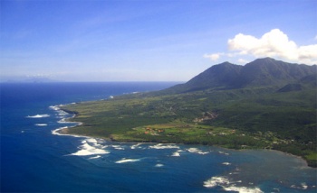
Nevis, along with Saint Kitts, forms the Federation of Saint Kitts and Nevis. The two islands are separated by a shallow two-mile (3.22 km) channel, known as The Narrows. Nevis is conical in shape, with a volcanic peak, Nevis Peak, at its centre. The island is fringed on its western and northern quadrants by sandy beaches that are composed of a mixture of white coral sand with brown and black sand, eroded and washed down from the volcanic rocks that make up the island. The gently-sloping coastal plain has natural fresh-water springs, as well as non-potable volcanic hot springs, especially along the western coast.
There are visible wave-breaking reefs along the northern and eastern shorelines. To the south and west, the reefs are located in deeper water and are suitable for scuba diving. The most developed beach on Nevis is the 4-mile long Pinney's Beach, on the western or Caribbean coast. There are sheltered swimming beaches in Oualie Bay and Cades Bay. The eastern coast of the island faces into the Atlantic Ocean, and can have strong surf in parts of the shore which are unprotected by fringing coral reefs.
Charts
Submit the chart details that are required for safe navigation.
Sailing instructions and sketch charts for navigation are best found in Chris Doyles' "Cruising Guide to the Leeward Islands".
Radio Nets
Also see Cruiser's Nets
Submit details of local radio Nets.
Routes to/from
Popular routes, timing, etc.
- St Kitts to Nevis (The Narrows): Describe passage ...
Check-in facilities
Yachts clearing in to Nevis should pick up one of the five yellow Quarantine bouys located off the ferry dock at Charlestown. The dinghy dock is on the smaller concrete pier just to the south of the ferry pier.
Proceed to Customs, located on the second floor of the Cotton Ginnery, which is through a courtyard behind the dock area. When clearing in be sure to ask for a coastwise cruising permit if you intend to visit other anchorages. Customs is open 0800-1200, 1300-1600 weekdays, and half day on Saturday.
Immigration is located in the police station, to the right on main street about three blocks. Captains should also check in with the Port Authority at the Charlestown dock to arrange for a mooring.
If you have already cleared in on St. Kitts, contact the Nevis Port Authority on VHF 16 when approaching the island and ask for instructions.
The Nevis Port Authority has installed 100 yacht mooring buoys along the western coast, and now requires yachts to pick up a mooring; anchoring is no longer permitted. The mooring fields are laid out at Pinney's Beach (from the Double Deuce to Sunshine's), Nelson's Spring, Cades Bay, Tamarind Bay (5) and Oualie Bay (3). The moorings are first class.
Mooring fees for 2008-2010 are:
- Up to 35' - $10 US for up to two days, $15 for 3-7 days;
- 36' - 60' - $15 US for up to two days, $20 for 3-7 days;
- 61' - 90' - $20 US for up to two days, $25 for 3-7 days.
- The fees are the total cost for the time period, not per day.
Contact informaton: Port Authority phone: 869-469-0788/0651; Email
Marinas & Yacht Clubs
Nevis has no marina, although plans are in the works. First class moorings are available at very reasonable prices compared to other islands.
Port Zante Marina, in Basseterre on St. Kitts offers slips, fuel and water. Call 1-869-469-5021 and ask to be connected to the marina, or hail them on VHF 16.
Health & Security
Crime involving cruising yachts is essentially non-existent in St. Kitts and Nevis, however one should still lock the dinghy and button up the boat when ashore as a precaution.
Anchorages
Anchorages on St. Kitts and Nevis are best described in Chris Doyles' "Cruising Guide to the Leeward Islands".
Nevis: Gallows Bay, Charlestown - Five yellow quarantine buoys for clearing in. Pinney's Beach (from south to north): Double Deuce, Chevy's, Sunshine's, The Four Seasons Resort, Mango. Ample moorings at relative low prices. Cades Bay - Chrishi Beach bar. Tamarind Bay - No facilities ashore. Oualie Bay - Oualie Beach Hotel, water sports, SCUBA, bike rental, snorkeling concessions.
Tourism & things to do ashore
List places of interest, tours, eateries, etc.
Marine stores
- The Boat Store at Caribbean Canvas on Prince William Street in Charlestown has a limited inventory of boat related items.
Hardware stores are TDC, Hosford's and Island Tyres.
Offshore Islands
List Islands
References & Publications
Publications, Guides, etc.
Cruiser's Friends
Contact details of "Cruiser's Friends" that can be contacted for local information or assistance.
Forum Discussions
List links to discussion threads on the Cruiser Log Forum
External Links
Links to relevant websites.
Personal Notes
- Many agree that Nevis is home to the friendliest people in the eastern Caribbean!
| |
|---|
| | HOMEPAGE | Wiki Contents | Caribbean | St Kitts and Nevis |Charlestown - Nevis | |
.
