Davao
From CruisersWiki
Lighthouse (Talk | contribs) (→Approach and Navigation) |
(→Cruiser's Friends) |
||
| Line 91: | Line 91: | ||
===Cruiser's Friends=== | ===Cruiser's Friends=== | ||
Contact details of "Cruiser's Friends" that can be contacted for local information or assistance. | Contact details of "Cruiser's Friends" that can be contacted for local information or assistance. | ||
| - | * '''Ellen Lee-Kwen and Kjartan Sekkingstad''', ''SV Wiskun'', email: wiskun | + | * '''Ellen Lee-Kwen and Kjartan Sekkingstad''', ''SV Wiskun'', email: wiskun@msn.com |
* | * | ||
Revision as of 04:58, 29 May 2008
Davao
Background
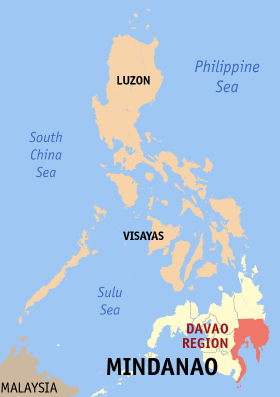
Davao Port, or the "Port of Davao" is one of the Philippines major seaports alongside Manila, Subic, Cebu and others. The Port of Davao, oftentimes called Port District of Davao, includes Davao City and the three provinces. Davao port services interisland and international shipments. The city is situated 974 kilometers south of Manila, on the shore of Davao Gulf. "Davao" also refers to three provinces: Davao del Norte, Davao del Sur, and Davao Oriental. Davao City is located in Davao del Sur but is politically and administratively independent of the province.
Davao City in southern Mindanao is typhoon free and winds are mostly not stronger than Force 4. It is a safe haven for riding out the typhoon season and for storing vessels while yachties fly home. There are direct flights to some southeast asian cities from here, or connections are available to anywhere in the world from Manila.
Charts
Submit the chart details that are required for safe navigation.
Radio Nets
Also see Cruiser's Nets
Submit details of local radio Nets.
Local climate and weather
The region has a generally uniform distribution of rainfall through the year. It lies outside the typhoon belt.
Weather forecast sources:
The access to the port of entry in Davao City is through Davao Gulf which has two approaches. One is at Pakiputan Strait between Davao and the water west of Samal Island. The other approach is at the east side of Samal Island mainly used as an exit channel of vessels departing from points north of Davao Gulf.
Check-in facilities
Yachts should "hold" at anchor 50-100m off the southern Sta. Anna Wharf (approx. 07 04.53N, 125 37.74E) to await clearance. Calls on VHF 16 are often unanswered or very slow to reply - Customs and Quarantine can alternatively be called on Ph: 2331258 (ask them to notify Immigration of your arrival). All the officials will visit your boat and will advise you where to berth after full clearance formalities are completed.
Marinas & Yacht Clubs
Submit Marina details.
Anchorages
List details of all safe anchorages in the area.
Offshore Islands
- Samal (Island Garden City of Samal)
Routes/Passages To/From
Popular passages/routes, timing, etc.
Tourism & things to do ashore
List places of interest, tours, eateries, etc.
Fuel, Water, & Electricity
Laundry
Grocery Stores
Eateries
Motorbike & Car Rentals
Marine Stores & Facilities
Submit addresses and contact details of marine related businesses that are of interest to cruisers.
Repairs
Transportation
Transportation to mainland or other countries, etc.
- Philippine Air lines
- Cebu Pacific Airlines
References & Publications
Publications, Guides, etc.
Cruiser's Friends
Contact details of "Cruiser's Friends" that can be contacted for local information or assistance.
- Ellen Lee-Kwen and Kjartan Sekkingstad, SV Wiskun, email: [email protected]
Forum Discussions
List links to discussion threads on the Cruiser Log Forum
External Links
Links to relevant websites.
Personal Notes
Personal experiences?
.
