Diaporos Island
From CruisersWiki
Istioploos (Talk | contribs) m (→Last Visited & Details Checked (and updated here): Typo) |
Istioploos (Talk | contribs) (Coords & minor edits) |
||
| Line 1: | Line 1: | ||
== Diaporos Island== | == Diaporos Island== | ||
| - | + | GPS: {{Coord|40|13|N|23|47.5|E|}} | |
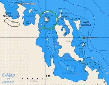
| - | [[Image:Greece_Diaporos_m.jpg|350px|thumb|right|Chart of the Diaporos Region<br/>''Click for larger view'']] | + | [[Image:Greece_Diaporos_m.jpg|350px|thumb|right|Chart of the Diaporos Region - [http://mapserver.maptech.com/homepage/index.cfm?lat=40.216667&lon=23.791667&scale=300000&zoom=100&type=0&icon=0&searchscope=dom&CFID=1509264&CFTOKEN=22608242&scriptfile=http://mapserver.maptech.com/homepage/index.cfm&latlontype=DMS Chartlet]<br/>''Click for larger view'']] |
===Background=== | ===Background=== | ||
| Line 27: | Line 27: | ||
===Anchorages=== | ===Anchorages=== | ||
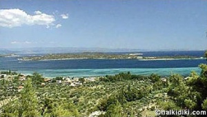
| - | [[Image:Greece_Diaporos.jpg| | + | [[Image:Greece_Diaporos.jpg|300px|thumb|right|Diaporos Island<br/>''Click for larger view'']] |
====Krifos Bay==== | ====Krifos Bay==== | ||
| + | GPS: {{Coord|40|13.4|N|23|46.9|E|}}<br/> | ||
Krifos Bay is on the N side of Diaporos Island. Proceed between Ambelisti Island and Cape Kokakies. The bottom is sand, good holding. | Krifos Bay is on the N side of Diaporos Island. Proceed between Ambelisti Island and Cape Kokakies. The bottom is sand, good holding. | ||
====Koumaroudes Bay==== | ====Koumaroudes Bay==== | ||
| + | GPS: {{Coord|40|12.2|N|23|46.8|E|}}<br/> | ||
Koumaroudes Bay on the W side of Diaporos Island. The bottom is sand, good holding. | Koumaroudes Bay on the W side of Diaporos Island. The bottom is sand, good holding. | ||
====Mesopanayia Bay==== | ====Mesopanayia Bay==== | ||
| + | GPS: {{Coord|40|11.4|N|23|47.3|E|}}<br/> | ||
Mesopanayia Bay is on the S side of Diaporos Island. The bottom is sand, good holding. | Mesopanayia Bay is on the S side of Diaporos Island. The bottom is sand, good holding. | ||
====Dimitriaki Bay==== | ====Dimitriaki Bay==== | ||
| + | GPS: {{Coord|40|13.6|N|23|45.4|E|}}<br/> | ||
Dimitriaki Bay is on the mainland and E of Diaporos Island. The bottom is sand, good holding. Unfortunately there is a fish-farm. | Dimitriaki Bay is on the mainland and E of Diaporos Island. The bottom is sand, good holding. Unfortunately there is a fish-farm. | ||
====Ayios Nikolaos==== | ====Ayios Nikolaos==== | ||
| + | GPS: {{Coord|40|13.9|N|23|44.3|E|}}<br/> | ||
Ayios Nikolaos is a village on the mainland and NW of Dimitriaki Bay. The bottom is mud, good holding. | Ayios Nikolaos is a village on the mainland and NW of Dimitriaki Bay. The bottom is mud, good holding. | ||
| Line 117: | Line 122: | ||
! <h2 id="mp-itn-h2" style="margin:0; background:#cedff2; font-size:120%; font-weight:bold; border:1px solid #a3b0bf; text-align:left; color:#000; padding:0.2em 0.4em;">Cruising Wiki Navigation</h2> | ! <h2 id="mp-itn-h2" style="margin:0; background:#cedff2; font-size:120%; font-weight:bold; border:1px solid #a3b0bf; text-align:left; color:#000; padding:0.2em 0.4em;">Cruising Wiki Navigation</h2> | ||
|- | |- | ||
| - | |style="color:#000;"| | [[Cruising_and_Sailing_Wiki_by_CruiserLog|HOMEPAGE]] | [[Cruising|Wiki Contents]] | [[Med|Mediterranean]] | [[Greece]] | [[Diaporos]] | | + | |style="color:#000;"| | [[Cruising_and_Sailing_Wiki_by_CruiserLog|HOMEPAGE]] | [[Cruising|Wiki Contents]] | [[Med|Mediterranean]] | [[Aegean Sea]] | [[Greece]] | [[Diaporos]] | |
|} | |} | ||
. | . | ||
Revision as of 14:07, 21 February 2009
Diaporos Island
GPS: 40°13′N, 23°47.5′E
Background
The region of Diaporos or Dhiaporos (Διάπορος) or Dhimitri island is a yachtsman's paradise. There several deserted landlocked coves surrounded by pine trees and sandy beaches. There are many reefs where one can snorkel in the clear water.
Charts
- BA 1086 Srimonikos kólpos to Edremit Körfezi
- Imray-Tetra G2 Aegean Sea (North)
- NIMA 54360 Thessaloniki to Canakkale Bogazi Dardanelles
- Greek 31 North Evoikos to Kavala Gulf
- Greek 47 Aigaion Pelagos Northern Part
Radio Nets
Also see Cruiser's Nets
- Coast Guard - VHF channel 12
- Olympia Radio - VHF channels 26 & 27
Approach to the region is either from the S Passage through the narrow channel between Diaporos Island and Cape Xifaras or through the wider N Passage between the NE of Diaporos and the Peristeri Islands.
Warning: A good detailed chart and a lookout are necessary because of the many reefs surrounding both passages.
Anchorages
Krifos Bay
GPS: 40°13.4′N, 23°46.9′E
Krifos Bay is on the N side of Diaporos Island. Proceed between Ambelisti Island and Cape Kokakies. The bottom is sand, good holding.
Koumaroudes Bay
GPS: 40°12.2′N, 23°46.8′E
Koumaroudes Bay on the W side of Diaporos Island. The bottom is sand, good holding.
Mesopanayia Bay
GPS: 40°11.4′N, 23°47.3′E
Mesopanayia Bay is on the S side of Diaporos Island. The bottom is sand, good holding.
Dimitriaki Bay
GPS: 40°13.6′N, 23°45.4′E
Dimitriaki Bay is on the mainland and E of Diaporos Island. The bottom is sand, good holding. Unfortunately there is a fish-farm.
Ayios Nikolaos
GPS: 40°13.9′N, 23°44.3′E
Ayios Nikolaos is a village on the mainland and NW of Dimitriaki Bay. The bottom is mud, good holding.
Tourism & things to do ashore
Nice walks.
Fuel, Water, & Electricity
- Fuel - There is a fuel station in Ayios Nikolaos, you have to use jerry cans
- Water - N/A
- Electricity - N/A
Laundry
N/A.
Grocery & Supply Stores
Limited supplies in in Ayios Nikolaos.
Eateries
There are a few tavernas in Ayios Nikolaos.
Internet/WiFi
Available?
Motorbike & Car Rentals
N/A.
Marine Stores & Facilities
None.
Repairs
Garbage Disposal
Trash cans in Ayios Nikolaos.
Transportation
There are busses from Ayios Nikolaos to Thessaloniki.
Routes/Passages To/From
Popular passages/routes, timing, etc.
References & Publications
See Greece.
Cruiser's Friends
Contact details of "Cruiser's Friends" that can be contacted for local information or assistance.
Forum Discussions
List links to discussion threads on the Cruiser Log Forum
External Links
- Diaporos Island (Wikipedia)
Personal Notes
Personal experiences?
Last Visited & Details Checked (and updated here)
Date of member's visit to this Port/Stop & this page's details validated:
- May 1991 --Istioploos 19:13, 27 November 2008 (UTC)
| |
|---|
| | HOMEPAGE | Wiki Contents | Mediterranean | Aegean Sea | Greece | Diaporos | |
.

