Hawaii
From CruisersWiki
Hawaii Cruising Guide
An online cruising guide for sailing around the islands of Hawaii.
| Hawaii | |
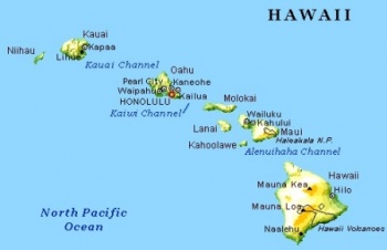
 Hawaii Click for larger view | |
 Flag | |
| Capital: | Honolulu |
|---|---|
| Language: | English, Hawaiian |
| Currency: | ?? |
| Time Zone | UTC ?? |
| More notes about the country | |
Background
The Hawaiian Islands, once known as the Sandwich Islands, form an archipelago of 19 islands and atolls, numerous smaller islets, and undersea seamounts trending northwest by southeast in the North Pacific Ocean between latitudes 19° N and 29° N. The archipelago takes its name from the largest island in the group and extends some 1,500 miles (2,400 km) from the Island of Hawaii in the south to northernmost Kure Atoll. Excluding Midway, which is an unincorporated territory of the United States, the Hawaiian Islands form the U.S. State of Hawaii.
This archipelago represents the exposed peaks of a great undersea mountain range known as the Hawaiian-Emperor seamount chain, formed by volcanic activity over a hotspot in the earth's mantle. At about 1,860 miles (3,000 km) from the nearest continent, the Hawaiian Island archipelago is the most isolated grouping of islands on Earth.
Describe the cruising/sailing in the region.
Climate & Weather
The islands receive most rainfall from the trade winds on their north and east flanks (called the windward side) as a result of orographic precipitation. Coastal areas in general and especially the south and west flanks or leeward sides, tend to be drier. Because of the frequent build-up of Tradewind clouds and potential showers, most tourist areas have been built on the leeward coasts of the islands.
In general, the Hawaiian Islands receive most of their precipitation during the winter months (October to April). Drier conditions generally prevail from May to September, but the warmer temperatures increase the risk of hurricanes (see below).
Temperatures at sea level generally range from high temperatures of 85-90 °F (29-32 °C) during the summer months to low temperatures of 65-70 °F (18-21 °C) during the winter months. Very rarely does the temperature rise above 90 °F (32 °C) or drop below 60 °F (16 °C) at lower elevations. Temperatures are lower at higher altitudes; in fact, the three highest mountains of Mauna Kea, Mauna Loa, and Haleakala sometimes receive snowfall during the winter.
The wind patterns on the islands are very complex. Though the trade winds are fairly constant in speed and duration, their relatively uniform air flow is distorted and disrupted by mountains, hills, and valleys. The usual regime is to have upslope winds by day and downslope winds by night. Local conditions that produce occasional violent winds are not well understood, even though the general causes of these winds can be surmised. These are very localized winds, observed only in a few areas. They sometimes reach speeds of 60 to 100 mph (160 km/h) and are best known in the settled areas of Kula and Lahaina on Maui. The Kula winds' are strong downslope winds that occur on the lower slopes of the west side of Haleakala. These winds tend to be strongest between 2,000 and 4,000 feet (1,200 m) above mean sea level. The Lahaina winds are also downslope winds, but have somewhat different characteristics. They are also called “lehua winds” after the lehua tree, whose red blossoms fill the air when these strong winds blow. They issue from the canyons at the base of the main mountain mass of western Maui, where the steeper canyon slopes meet the more gentle piedmont slope below. These winds are quite infrequent, occurring every 8 to 12 years. They are extremely violent, with wind speeds of 80 to 100 mph (160 km/h) or more.
Sources of weather forecasting here.
Charts
Submit details of the charts required for safe navigation of the area.
Any navigation notes here.
Local Radio Nets
Also see Cruiser's Nets
Arrival/Departure procedures
Submit any details about advance notification of arrival, etc.
Immigration
Details?
Customs
Details?
Ports & Popular Stops
Submit Ports and stop-overs
Islands
Details?
Health
Submit any health warnings/information and any security details here.
Security
Details?
Transportation
Transportation to mainland or other countries, etc.
References & Publications
Books, Guides, etc.
References & Publications
Publications, Guides, etc.
Cruiser's Friends
Contact details of "Cruiser's Friends" that can be contacted for local information or assistance.
Forum Discussions
List links to discussion threads on the Cruiser Log Forum
External Links
Personal Notes
Personal experiences?
| |
|---|
| | HOMEPAGE | Wiki Contents | Central Pacific | Hawaii | |
.