Ierapetra
From CruisersWiki
Istioploos (Talk | contribs) m (Reverted edits by Riley Huntley (talk) to last revision by Istioploos) |
Istioploos (Talk | contribs) m (Headings) |
||
| Line 2: | Line 2: | ||
{| class="infobox bordered" style="width: 28em; text-align: left; font-size: 90%;" | {| class="infobox bordered" style="width: 28em; text-align: left; font-size: 90%;" | ||
|- | |- | ||
| - | | colspan="2" style="text-align:center; font-size: smaller;" | {{Small info}} | + | | colspan="2" style="text-align:center; font-size: smaller;" | {{Small info}} ''(Click links for more information)'' |
|- | |- | ||
! <center>[[image:World_icon.png]]</center> | ! <center>[[image:World_icon.png]]</center> | ||
| Line 12: | Line 12: | ||
! <center>[[image:Chart_icon.png]]</center> | ! <center>[[image:Chart_icon.png]]</center> | ||
| [http://mapserver.maptech.com/homepage/index.cfm?lat=35.003333&lon=25.74&scale=150000&zoom=100&type=0&icon=0&searchscope=dom&CFID=1509264&CFTOKEN=22608242&scriptfile=http://mapserver.maptech.com/homepage/index.cfm&latlontype=DMS Local chartlet] | | [http://mapserver.maptech.com/homepage/index.cfm?lat=35.003333&lon=25.74&scale=150000&zoom=100&type=0&icon=0&searchscope=dom&CFID=1509264&CFTOKEN=22608242&scriptfile=http://mapserver.maptech.com/homepage/index.cfm&latlontype=DMS Local chartlet] | ||
| - | | | + | |- |
| - | {{TOCleft}} | + | | colspan="2" style="text-align:center; font-size: smaller;" | [[Image:Greece_Crete_Ierapetra_S.jpg|350px]]Satellite View of Ierapetra - ''Click for larger view'' |
| - | [http://en.wikipedia.org/wiki/Ierapetra Ierapetra] (Ιεράπετρα) is a town with a small harbor in southeast Crete. | + | |} {{TOCleft}}[http://en.wikipedia.org/wiki/Ierapetra Ierapetra] (Ιεράπετρα) is a town with a small harbor in southeast Crete. |
==Charts== | ==Charts== | ||
| - | |||
| - | |||
''See [[Crete#Charts|Crete]]''. | ''See [[Crete#Charts|Crete]]''. | ||
| Line 24: | Line 22: | ||
* Coast Guard - VHF channel 12 | * Coast Guard - VHF channel 12 | ||
* | * | ||
| - | |||
| - | |||
''See also'' [[Crete#Radio_Nets|Crete]]. | ''See also'' [[Crete#Radio_Nets|Crete]]. | ||
| Line 35: | Line 31: | ||
The approach should be made on a course of 000 degrees, staying close to the breakwater to avoid the shallows to the east of the harbour. There is also a shallow sandy patch immediately inside the breakwater on the port side, which should be given a good clearance. Further in, depths in the entrance are 2.5 - 3.5 meters, although the depths shoal toward the castle on starboard and, having avoided the sandy patch, it is best then to keep to port. | The approach should be made on a course of 000 degrees, staying close to the breakwater to avoid the shallows to the east of the harbour. There is also a shallow sandy patch immediately inside the breakwater on the port side, which should be given a good clearance. Further in, depths in the entrance are 2.5 - 3.5 meters, although the depths shoal toward the castle on starboard and, having avoided the sandy patch, it is best then to keep to port. | ||
| - | == | + | ==Berthing Options== |
| - | [[Image:Ierapetra.jpeg| | + | [[Image:Ierapetra.jpeg|345px|thumb|right|Ierapetra harbour<br />''Click for larger view'']] |
| + | |||
Ierapetra is essentially a working harbour, with little to offer yachts except an overnight berth on passage along the south coast of Crete or a refuge in unsettled weather. Local boats and tripper boats fill all of the quay space and it will be necessary to raft up wherever possible if you visit here. Depths are 2.5 to 3.5 meters throughout the harbour. An alternative in settled weather is to lie alongside the quay to port immediately outside the entrance, where depths are 2-3 meters (the deeper water being at the inner end). Beware rock ballasting in places. This quay is, however, exposed to any winds from the north and would probably be untenable in such conditions. | Ierapetra is essentially a working harbour, with little to offer yachts except an overnight berth on passage along the south coast of Crete or a refuge in unsettled weather. Local boats and tripper boats fill all of the quay space and it will be necessary to raft up wherever possible if you visit here. Depths are 2.5 to 3.5 meters throughout the harbour. An alternative in settled weather is to lie alongside the quay to port immediately outside the entrance, where depths are 2-3 meters (the deeper water being at the inner end). Beware rock ballasting in places. This quay is, however, exposed to any winds from the north and would probably be untenable in such conditions. | ||
| - | == | + | ===Marinas & Yacht Clubs=== |
None. | None. | ||
| - | == | + | ===Anchorages=== |
None. | None. | ||
| - | == | + | ==Offshore Islands and Groups== |
None. | None. | ||
| Line 64: | Line 61: | ||
: electricity notes | : electricity notes | ||
| - | == | + | ==Things to do Ashore== |
====Tourism==== | ====Tourism==== | ||
List places of interest, tours, etc. | List places of interest, tours, etc. | ||
| Line 102: | Line 99: | ||
==Forum Discussions== | ==Forum Discussions== | ||
| - | List links to discussion threads on [[Cruising Forums|partnering forums]]. (see link for requirements) | + | List links to discussion threads on [[Cruising Forums|partnering forums]]. (''see link for requirements'') |
| - | + | ||
* | * | ||
* | * | ||
| Line 113: | Line 109: | ||
==References & Publications== | ==References & Publications== | ||
| - | See [[Greece#References_&_Publications|Greece]]. | + | ''See [[Greece#References_&_Publications|Greece]]''. |
==Personal Notes== | ==Personal Notes== | ||
| Line 143: | Line 139: | ||
|} | |} | ||
| - | |||
[[Category:Ports - Greece]] [[Category:Ports - Crete]] | [[Category:Ports - Greece]] [[Category:Ports - Crete]] | ||
Revision as of 20:13, 22 February 2013
Ierapetra
| | |
| | 35°0.2′N, 25°44.4′E |
|---|---|
| | Photo gallery |
| | Local chartlet |
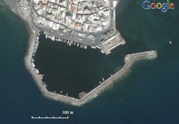
 Satellite View of Ierapetra - Click for larger view Satellite View of Ierapetra - Click for larger view
| |
Charts
See Crete.
Radio Nets
- Coast Guard - VHF channel 12
See also Crete.
Local Weather
See Aegean Sea.
The approach should be made on a course of 000 degrees, staying close to the breakwater to avoid the shallows to the east of the harbour. There is also a shallow sandy patch immediately inside the breakwater on the port side, which should be given a good clearance. Further in, depths in the entrance are 2.5 - 3.5 meters, although the depths shoal toward the castle on starboard and, having avoided the sandy patch, it is best then to keep to port.
Berthing Options
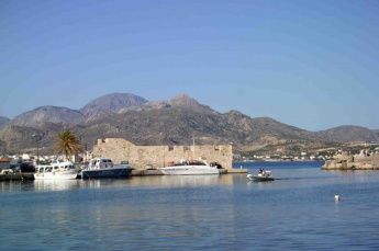
Ierapetra is essentially a working harbour, with little to offer yachts except an overnight berth on passage along the south coast of Crete or a refuge in unsettled weather. Local boats and tripper boats fill all of the quay space and it will be necessary to raft up wherever possible if you visit here. Depths are 2.5 to 3.5 meters throughout the harbour. An alternative in settled weather is to lie alongside the quay to port immediately outside the entrance, where depths are 2-3 meters (the deeper water being at the inner end). Beware rock ballasting in places. This quay is, however, exposed to any winds from the north and would probably be untenable in such conditions.
Marinas & Yacht Clubs
None.
Anchorages
None.
Offshore Islands and Groups
None.
Yacht Repairs and Services
Marine Stores
Submit addresses and contact details of marine related businesses that are of interest to cruisers.
Repairs/Yards
Fuel, Water, & Electricity
- Fuel
- fuel notes
- Water
- water notes
- Electricity
- electricity notes
Things to do Ashore
Tourism
List places of interest, tours, etc.
Grocery & Supply Stores
Eateries
Internet/WiFi
None.
Laundry
Motorbike & Car Rentals
Garbage Disposal
?
Transportation
Transportation (local and/or international)
Routes/Passages To/From
See Crete.
Cruiser's Friends
Contact details of "Cruiser's Friends" that can be contacted for local information or assistance.
Forum Discussions
List links to discussion threads on partnering forums. (see link for requirements)
External Links
- Ierapetra (Wikipedia)
References & Publications
See Greece.
Personal Notes
- A rather grubby and unprepossessing town, really a convenient stop-off on passage rather than a destination in itself (Athene of Lymington - June 2009).
Last Visited & Details Checked (and updated here)
Date of member's visit to this Port/Stop & this page's details validated:
- June 2009 -- Athene of Lymington
|
|---|
|
Names: Istioploos, Athene of Lymington |
| |
|---|
| | HOMEPAGE | Wiki Contents | | Mediterranean | Aegean Sea | Greece | Crete | Ierapetra | |
