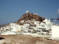
Ios
From CruisersWiki
Istioploos (Talk | contribs) |
Istioploos (Talk | contribs) m ({{Guide2}}) |
||
| Line 120: | Line 120: | ||
* | * | ||
| - | {{ | + | {{Guide2}} |
Revision as of 18:19, 11 July 2008
Ios
Click for larger view
Background
Ios (Ίος) for many cruisers is not a favorite island in the Cyclades. This is because the island has been completely overran by tourists,lots of them, and of the worst short: loud, aggressive, and hight on drugs.
There is tradition that Homer's mother came from Ios, and that Homer himself is buried here on the mountain near Plakotos which was an Ionian town and had a temple of Apollo.
Charts
- BA 1037 Nisís Falkonera to Nísos Ios
- Imray-Tetra G33 Southern Cyclades (West)
- NIMA 54320 Kiklades Nisoi to Kriti
- Greek 423 Paros to Astypalia
Radio Nets
Also see Cruiser's Nets
- Goast Guard - VHF channel 12
- Olympia Radio - VHF channels 61 & 62
Anchorages
Port Ios
| Port Ios or Yialos [36° 43.5' N 25° 16.5' E] is the only port on the island. It provides excellent shelter from the meltemi but it is so noisy with infernal disco music and loud beer parties, and worse, that it is impossible to sleep.
Moor stern-to the E quay or anchor off in the N corner of the bay. The bottom is mud and provides excellent holding. There is narrow cove [36° 43.4' N 25° 15.9' E] just NW of the harbor. One boat can squeeze in. It is a safe anchorage the but it can develop strong and uncomfortable swell and is exposed to the southerlies. The holding is good and it is very quiet in the evening after all the bathers have departed. Danger: There is a treacherous reef of Cape Xeres on the SE entrance of the bay. File:Ios hr.jpg Port Ios from the Town Click for larger view | File:Ios h.jpg Chart of Port Ios Click for larger view |
Milopotamos Bay
Milopotamos [36° 42.7' N 25° 17.5' E] is a bay just S of Port Ios. While the shelter here is good, but not as good as in Port Ios, it is a quieter place to spend the night. There are 4 coves that can be used. The two easternmost coves provide better shelter. The bottom is sand and weed; good holding.
Koumbaras BayThis is a bay N of Port Ios. The shelter here is average. | File:Ios Milopotamos h.jpg Chart of Milopotamos Bay Click for larger view |
Manganari Bay
Click for larger view
Manganari [36° 39.4' N 025° 22.1' E] is a large bay on S tip of the island. The bay affords good shelter from meltemi although there cane be intermittent gusts.
Anchor in 3-4 m at either the head of the bay or on the E. The bottom is sand and provides good holding.
Routes/Passages To/From
Popular passages/routes, timing, etc.
Tourism & things to do ashore
Ios the inland capital of the island used to be, some 20 years ago, charming with working windmills. Now, at least during the summer months, it is a madhouse.
Fuel, Water, & Electricity
N/A.
Laundry
Grocery & Supply Stores
- Many food stores in Port Ios
Eateries
- Bad restaurants in Port Ios
- Better tavernas in the town of Ios
Internet/WiFi
In Cafés
Motorbike & Car Rentals
In the town of Ios.
Marine Stores & Facilities
None.
Repairs
N/A.
Transportation
There are daily ferries and in the summer hydrofoils to other islands and to Piraeus.
References & Publications
See Greece.
Cruiser's Friends
Contact details of "Cruiser's Friends" that can be contacted for local information or assistance.
Forum Discussions
List links to discussion threads on the Cruiser Log Forum
External Links
- Ios (Wikipedia)
Personal Notes
I usually avoid this island. --Istioploos 16:21, 4 July 2008 (MDT)
Last Visited & Details Checked (and updated here)
Date of member's visit to this Port/Stop & this page's details validated:
- June 2001 --Istioploos 16:21, 4 July 2008 (MDT)
.

