Kekova Roads
From CruisersWiki
Istioploos (Talk | contribs) |
Istioploos (Talk | contribs) m (→Background) |
||
| Line 3: | Line 3: | ||
===Background=== | ===Background=== | ||
| - | Kekova Roads [36° 12' N 29° 50' E] is an enclosed bay protected by the 4 mile long [http://en.wikipedia.org/wiki/Kekova Kekova Island]. The Bay has several wonderful anchorages and an inner, completely land locked cove, Uçagiz Liman, which is always calm. There are several submerged foundations on the NW side of Kekova Island near [[#Tersane|Tersane]], in [[#Kale_Köy|Kale Köy]], and at Asar Bay, a 30 minute walk from [[#Pölemos_Bükü|Pölemos Bükü]]. At the NE there is the beautiful [[#Gökkaya_Liman|Gökkaya Liman] with many places to anchor from there you could visit with your dinghy Demre and Myra, just 2 nM away. On the south side of Kekova Adasi there is the lovely and secluded [[#Karaloz_Liman|Karaloz Liman]]. | + | Kekova Roads [36° 12' N 29° 50' E] is an enclosed bay protected by the 4 mile long [http://en.wikipedia.org/wiki/Kekova Kekova Island]. The Bay has several wonderful anchorages and an inner, completely land locked cove, Uçagiz Liman, which is always calm. There are several submerged foundations on the NW side of Kekova Island near [[#Tersane|Tersane]], in [[#Kale_Köy|Kale Köy]], and at Asar Bay, a 30 minute walk from [[#Pölemos_Bükü|Pölemos Bükü]]. At the NE there is the beautiful [[#Gökkaya_Liman|Gökkaya Liman]] with many places to anchor from there you could visit with your dinghy Demre and Myra, just 2 nM away. On the south side of Kekova Adasi there is the lovely and secluded [[#Karaloz_Liman|Karaloz Liman]]. |
During the day all of the anchorages at Kekova Roads are crowded with gulets and day-trip boats but in the evening thing do quiet down. | During the day all of the anchorages at Kekova Roads are crowded with gulets and day-trip boats but in the evening thing do quiet down. | ||
| - | |||
===Charts=== | ===Charts=== | ||
Revision as of 18:19, 9 July 2008
Kekova Roads
Background
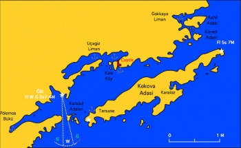
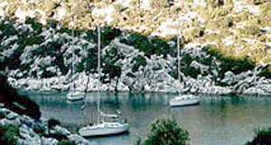
Kekova Roads [36° 12' N 29° 50' E] is an enclosed bay protected by the 4 mile long Kekova Island. The Bay has several wonderful anchorages and an inner, completely land locked cove, Uçagiz Liman, which is always calm. There are several submerged foundations on the NW side of Kekova Island near Tersane, in Kale Köy, and at Asar Bay, a 30 minute walk from Pölemos Bükü. At the NE there is the beautiful Gökkaya Liman with many places to anchor from there you could visit with your dinghy Demre and Myra, just 2 nM away. On the south side of Kekova Adasi there is the lovely and secluded Karaloz Liman.
During the day all of the anchorages at Kekova Roads are crowded with gulets and day-trip boats but in the evening thing do quiet down.
Charts
SBA 236 Hisarönü körfezi to Taslik burnu
Imray-Tetra G40 Kas to Antalya
Radio Nets
Also see Cruiser's Nets
Submit details of local radio Nets.
Warning: Care must be taken when entering Kekova Roads form the Karaölor Adalari entrance (west), especially under sail, to avoid the many rocks near Karaölor and because there can be very violent gusts.
Check-in facilities
None.
Anchorages
Pölemos Bükü
Click to enlarge
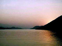
Pölemos Bükü [36° 10' N 29° 48.6' E] is the westernmost anchorage of Kekova Roads. You can anchor at 5-10 m near the shore. This is a very protected cove but subject to violent gusts that can easily reach 40 knots. It may be prudent to take a line ashore, as the bottom is soft mud and with the gusts the anchor may drag. There is a small restaurant at the end of the cove. About a 30 minute walk to the west, there is Asar Bay, the ancient Aperlae whose ruins are fun to visit as there are totally deserted and quite extensive but it is hard going as the terrain is very rough. One can snorkel to see the underwater foundations.
Last Visited & Details Checked (and updated here)
Date of member's visit to this Port/Stop & this page's details validated:
- August, 1997 --Istioploos 09:05, 7 June 2008 (MDT)
Uçagiz Liman
Click to enlarge
Uçagiz Liman or Ölü Deniz or Tristomos [36° 11.8' N 29° 50.9' E] is a land locked lagoon which is always calm, an excellent all around shelter. The water, however, is not clear but dirty. You can either dock or anchor off at 3-5 m. Good holding. In the hamlet of Uçagiz there are some wooden piers associated with several overpriced restaurants whose attendant will become you. East of the hamlet there are many sarcophagi and a rock tomb.
Last Visited & Details Checked (and updated here)
Date of member's visit to this Port/Stop & this page's details validated:
- August, 1997 --Istioploos 09:05, 7 June 2008 (MDT)
Kale Köy
Click to enlarge
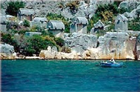
Kale Köy [36° 12' N 29° 52' E] the ancient Semena is a very picturesque location dominated by its castle and the tombs protruding from the water. It is hard to approach by boat because of the numerous reefs. Also the bottom is mud and weed over rock and does not provide secure holding. It is better to anchor inside Uçagiz Liman and visit Kale Köy with the dinghy. If you must go with your boat, it is best to use one of the moorings provided by the restaurants. Like Uçagiz this place is crowded by day and almost deserted by night.
The ancient theater, as well as the medieval castle, are well worth the climb. The theater is miniscule, just 7 rows of seats. The place is full of Turkish girls, in costume, selling scarves.
Click to enlarge
Last Visited & Details Checked (and updated here)
Date of member's visit to this Port/Stop & this page's details validated:
- August, 1997 --Istioploos 09:05, 7 June 2008 (MDT)
Gökkaya Liman
Click to enlarge
There are a number of anchorages, protected by a number of small islands, at this cove [36° 12.4' N 29° 54' E] at the eastern end of Kekova. The anchorages are very beautiful. Depths are 5-10 m, good holding, but it is best to tie a line to a rock ashore and prevent the boat from swinging. Like most of Kekova, the cove is crowded during the day. The water here is very clear.
There are two restaurants: one at the NW creek and the other on the N side of Ashil Adasi. It is possible to leave the boat here and visit Andraki, the harbor of Demre and Myra, just 2 nM ENE.
Last Visited & Details Checked (and updated here)
Date of member's visit to this Port/Stop & this page's details validated:
- August, 1997 --Istioploos 09:05, 7 June 2008 (MDT)
Offshore Islands
The only island here is Kekova Adasi. There are two anchorages on the island:
Tersane
Click to enlarge
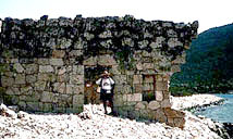
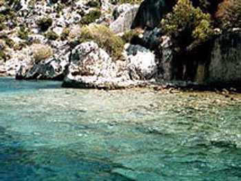
Tersane or Xera [36° 10.4' N 29° 50.8' E] is a tiny well sheltered cove on NW side of Kekova Island. If you can find room in this very crowded during the day cove, you can anchor at 4-5 m and take a line ashore. The bottom is sand and provides good holding. The cove is dominated by the collapsed arch of a Byzantine church. To the east of the cove, one can see many submerged ruins (Hellenistic, Roman, Byzantine). Snorkeling here, in the crystal-clear water, is definitely worth your while, despite the endless procession of day-trip boats with glass bottoms and loudspeakers.
Even if you cannot find room to anchor in Tersane, you could possibly visit it from Uçagiz with the dinghy.
Last Visited & Details Checked (and updated here)
Date of member's visit to this Port/Stop & this page's details validated:
- August, 1997 --Istioploos 09:05, 7 June 2008 (MDT)
Karaloz Liman
Click to enlarge
Karaloz Liman [36° 11' N 29° 53' E] or Port Saint Stefano is a completely landlocked cove on the south of Kekova Adasi. The cove is totally secluded and affords a wonderful anchorage, for several boats. The water is crystal-clear and the bottom is mad and weed with good holding. There can be, however, strong gusts so it is best to take a line ashore.
Last Visited & Details Checked (and updated here)
Date of member's visit to this Port/Stop & this page's details validated:
- August, 1997 --Istioploos 09:05, 7 June 2008 (MDT)
Routes/Passages To/From
Popular passages/routes, timing, etc.
Eateries
- In Pölemos Bükü
References & Publications
See Turkey.
Cruiser's Friends
Contact details of "Cruiser's Friends" that can be contacted for local information or assistance.
Forum Discussions
List links to discussion threads on the Cruiser Log Forum
External Links
Links to relevant websites.
Personal Notes
Personal experiences?
Last Visited & Details Checked (and updated here)
See individual ports in this page.
.
