Lefkas Canal
From CruisersWiki
(→Charts) |
(→Approach from N) |
||
| Line 38: | Line 38: | ||
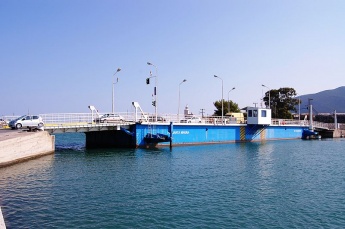
{{image right|Lefkas Santa Maura shipbridge.jpg|Lefkas Santa Maura bridge}} | {{image right|Lefkas Santa Maura shipbridge.jpg|Lefkas Santa Maura bridge}} | ||
{{image right|Lefkas swing bridge.jpg|Lefkas bridge opened}} | {{image right|Lefkas swing bridge.jpg|Lefkas bridge opened}} | ||
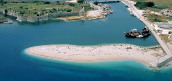
| + | {{image right|LefkasEntranceWaterViewN.jpg|The N entrance to Lefkas Canal Water Level View}} | ||
Approaching Lefkas from the N is tricky, especially for a first time visitor and even more so if there are fresh to strong NW winds with the afternoon seabreeze, which cause a difficult swell as they break on the shore around the entrance. In such conditions it is wise to take down all sail well before arriving. | Approaching Lefkas from the N is tricky, especially for a first time visitor and even more so if there are fresh to strong NW winds with the afternoon seabreeze, which cause a difficult swell as they break on the shore around the entrance. In such conditions it is wise to take down all sail well before arriving. | ||
Revision as of 18:56, 2 March 2015
Lefkas Canal
| Lefkas Canal
| |
N Entrance
| |
S Entrance
| |
|
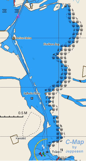
Lefkas Canal runs for around 3.5 miles through the low-lying land at the NE end of the island and divides it from the Greek mainland.
The canal, which is dredged to a depth of 5.0 – 6.0 metres along most of its length, is shallow in places, especially at its N entrance, where depths are sometimes little more than 3.5 – 4.0 metres, and about two thirds of the way down from the N, where depths reduce at one point to around 3.5 metres.
The N part of the canal runs between training walls as far as Lefkas Town and is marked by poles (a few of them with red and green markers) for the rest of its length until arriving at the three pairs of buoys at the S end. In places, the channel is quite narrow, and north-going and south-going yachts may be competing for the deeper water in the centre of the channel.
There is a speed limit of 4.0 knots in the canal and sometimes an appreciable current of 1.0 – 1.5 knots, usually S-going.
The road from the mainland passes over the canal at its N end via a floating bridge which opens on the hour from 0600 – 2200 but only on request outside those times.
The bridge keeps listening watch on VHF channel 12 "Floating Bridge Santa Maura".
Charts
see Lefkas
Radio Nets
Also see World Cruiser's Nets.
Approach from N
Approaching Lefkas from the N is tricky, especially for a first time visitor and even more so if there are fresh to strong NW winds with the afternoon seabreeze, which cause a difficult swell as they break on the shore around the entrance. In such conditions it is wise to take down all sail well before arriving.
The entrance is around a long sand spit defining the N side of the channel. The entrance regularly silts up over the winter and requires virtually constant dredging. Dredging is performed from a crane working on the end of the sand spit and thus it is usually deepest on that side.
The other, S side of the channel is marked with a series of small red buoys which do not always indicate the best depths (it is advisable when leaving the channel to head N to stay at least 10-15 metres off them). A yacht passing through in May 2012 and keeping only five metres off the N side recorded a minimum depth of 3.8 metres.
After rounding the spit, the channel turns S after 200 metres and the floating bridge is dead ahead. The bridge opening is signified by the sounding of a siren. All road traffic onto and off the island is halted for the period of opening, so naturally the bridge operator is anxious to close it again as soon as possible.
Yachts tend to bunch on both sides of the bridge to await the opening and any stragglers probably won’t make it. In theory, the S-going traffic has priority over the N-going, but in reality the pressure to close the bridge quickly means that everyone charges through in single file at speed as soon as the bridge opens (of course, observing the usual port-to-port rule, without which there is chaos).
If arriving before the bridge opens, it is possible to tie up alongside (or just hang off by the bow) the wall on the N side of the channel (although there are very few attachments to take a line to). If it is not very busy, it is possible with care to drop anchor temporarily on the 'bend' of the channel.
Approach from S
Approaching from the S is relatively straightforward as long as you identify the first set of three pairs of port and starboard buoys which mark the entrance to the canal. There is a conspicuous ruined Venetian fort a couple of hundred metres to starboard of the canal which is a useful landmark from distance.
The channel passes between some dangerous rocks on the starboard side and the remains of a ruined breakwater to port, so it is important to stay between the buoys.
If arriving at Lefkas Town before the bridge opens, it is possible to anchor temporarily off the town (see Lefkas Town page for details).
Routes/Passages To/From
List popular passages/routes, timing, etc.
Cruiser's Friends
Contact details of "Cruiser's Friends" that can be contacted for local information or assistance.
Forum Discussions
List links to discussion threads on partnering forums. (see link for requirements)
External Links
List links external to the wiki such as in Wikepedia.
References & Publications
See Greece.
Personal Notes
Personal experiences?
Last Visited & Details Checked (and updated here)
Date of member's visit to this Port/Stop & this page's details validated:
- September 2011 --Vadp
|
|---|
|
Names: Vadp |
| |
|---|
| | HOMEPAGE | Wiki Contents | Mediterranean | Greece | Lefkas | Lefkas Canal | | |


