Levitha and Kinaros
From CruisersWiki
Istioploos (Talk | contribs) (New Material) |
Istioploos (Talk | contribs) (Coords & Edits) |
||
| Line 1: | Line 1: | ||
==Levitha and Kinaros== | ==Levitha and Kinaros== | ||
| - | [[Image: | + | GPS: {{Coord|37|0.14|N|26|28.06|E|}} (Levitha)<br/> |
| + | GPS: {{Coord|36|58.4|N|26|17.4|E|}} (Kinaros) | ||
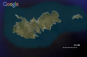
| + | [[Image:Greece_Levitha_S.jpg|350px|thumb|right|Satellite View of Levitha - [http://mapserver.maptech.com/homepage/index.cfm?lat=37.00244769128322&lon=26.459637388491505&scale=150000&zoom=100&type=0&icon=0&width=498&height=498&searchscope=dom&CFID=1509264&CFTOKEN=22608242&scriptfile=http://mapserver.maptech.com/homepage/index.cfm&latlontype=DMS Chartlet]<br/>''Click for larger view'']] | ||
===Background=== | ===Background=== | ||
| Line 33: | Line 35: | ||
====East Cove==== | ====East Cove==== | ||
{| | {| | ||
| - | |valign="top"|This is the cove recommended by the pilot books | + | |valign="top"|GPS: {{Coord|37|0.14|N|26|28.06|E|}} |
| + | This is the cove recommended by the pilot books. It has a small pier which is used by the fishermen. With strong westerly winds there is enough fetch across the bay to make it uncomfortable. The bottom is littered with debris that can foul the anchor. Be prepared for dragging. | ||
| - | In 1999 Mr. Kamposos installed several permanent moorings which make life much easier. He does charge a fee (€ 7 in 2008) | + | In 1999 Mr. Kamposos installed several permanent moorings which make life much easier. He does however charge a fee (€ 7 in 2008). |
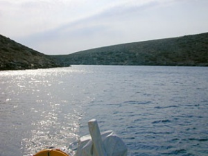
[[Image:Greece_LevithaAnch.jpg|300px|thumb|center|The East cove at Levitha<br/>''Click for larger view'']] | [[Image:Greece_LevithaAnch.jpg|300px|thumb|center|The East cove at Levitha<br/>''Click for larger view'']] | ||
| Line 44: | Line 47: | ||
====North Cove==== | ====North Cove==== | ||
{| | {| | ||
| - | |valign="top"| | + | |valign="top"|GPS: {{Coord|37|0.17|N|26|27.78|E|}} |
| + | This small cove is just about 1/2 nM W of the [[#East_Cove|East Cove]] and is very well sheltered form the westerlies but it is open to the S wind. Drop the anchor as close as possible to the NE corner and back to the S. Then take a long line (about 80 m) from the bow to the W shore. | ||
I weathered in 1998 a force 8 gale in this cove. --[[User:Istioploos|Istioploos]] 18:32, 3 November 2008 (UTC) | I weathered in 1998 a force 8 gale in this cove. --[[User:Istioploos|Istioploos]] 18:32, 3 November 2008 (UTC) | ||
| Line 57: | Line 61: | ||
====West Cove==== | ====West Cove==== | ||
{| | {| | ||
| - | |valign="top"|This is also a very attractive cove. Very clean but more subject to WNW gusts than the North Cove. It should be better protected from the S. wind. | + | |valign="top"|GPS: {{Coord|36|59.88|N|26|27.14|E|}} |
| + | This is also a very attractive cove. Very clean but more subject to WNW gusts than the North Cove. It should be better protected from the S. wind. | ||
|valign="top"|[[Image:Greece_Levitha_Wcove.jpg|350px|thumb|right|Chart of the West Cove<br/>''Click for larger view'']] | |valign="top"|[[Image:Greece_Levitha_Wcove.jpg|350px|thumb|right|Chart of the West Cove<br/>''Click for larger view'']] | ||
| Line 64: | Line 69: | ||
====Vathi==== | ====Vathi==== | ||
{| | {| | ||
| - | |valign="top"|According to [[Greece#References_&_Publications|Heikell]], this cove is protected from the ''meltemi.'' But it does not look after all to be a very good anchorage because of its great depths. | + | |valign="top"|GPS: {{Coord|36|59.97|N|26|26.22|E|}} |
| + | According to [[Greece#References_&_Publications|Heikell]], this cove is protected from the ''meltemi.'' But it does not look after all to be a very good anchorage because of its great depths. | ||
| Line 73: | Line 79: | ||
====Kinaros==== | ====Kinaros==== | ||
{| | {| | ||
| - | |valign="top"|There is only one cove in the small island of Kínaros (Κύναρος) | + | |valign="top"|GPS: {{Coord|36|58.4|N|26|17.4|E|}} |
| + | There is only one cove in the small island of Kínaros (Κύναρος). It looks like a very good place and well sheltered from the northerly ''meltemi.'' There is only a single house here. The cove is narrow and one has to anchor in about 5 m depth and maybe take two lines ashore to keep the boat from drifting to the rocks. | ||
| - | |valign="top"|[[Image: | + | |valign="top"|[[Image:Greece_Kinaros_S.jpg|350px|thumb|right|Satellite view of Kinaros - [http://mapserver.maptech.com/homepage/index.cfm?lat=36.973333&lon=26.29&scale=150000&zoom=100&type=0&icon=0&searchscope=dom&CFID=1509264&CFTOKEN=22608242&scriptfile=http://mapserver.maptech.com/homepage/index.cfm&latlontype=DMS Chartlet]<br/>''Click for larger view'']] |
|} | |} | ||
===Tourism & things to do ashore=== | ===Tourism & things to do ashore=== | ||
| Line 149: | Line 156: | ||
! <h2 id="mp-itn-h2" style="margin:0; background:#cedff2; font-size:120%; font-weight:bold; border:1px solid #a3b0bf; text-align:left; color:#000; padding:0.2em 0.4em;">Cruising Wiki Navigation</h2> | ! <h2 id="mp-itn-h2" style="margin:0; background:#cedff2; font-size:120%; font-weight:bold; border:1px solid #a3b0bf; text-align:left; color:#000; padding:0.2em 0.4em;">Cruising Wiki Navigation</h2> | ||
|- | |- | ||
| - | |style="color:#000;"| | [[Cruising_and_Sailing_Wiki_by_CruiserLog|HOMEPAGE]] | [[Cruising|Wiki Contents]] | [[Med|Mediterranean]] | | + | |style="color:#000;"| | [[Cruising_and_Sailing_Wiki_by_CruiserLog|HOMEPAGE]] | [[Cruising|Wiki Contents]] | [[Med|Mediterranean]] | [[Aegean Sea]] | [[Greece]] | [[Levitha and Kinaros]] | |
|} | |} | ||
. | . | ||
Revision as of 20:29, 27 February 2009
Levitha and Kinaros
GPS: 37°0.14′N, 26°28.06′E (Levitha)
GPS: 36°58.4′N, 26°17.4′E (Kinaros)
Background
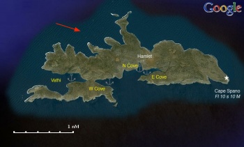
Levitha (Λέβιθα) or Levithia (Λεβίθια) is a small low lying island with 4 (yes, four) inhabitants. Its nearest neighbor is Kinaros. During the summer months both islands are frequented by fishing boats and sailing yachts that take advantage of their protected coves. It is a very attractive and out of the way place.
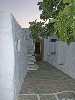
The inhabitants are all members of the Kamposos family (Demetris, Irene and their sons Tasos and Manolis). They live on a neat hamlet and raise animals. In the summer they also ran a small but very attractive and spotless restaurant for the visiting yachts. They grill to perfection fresh fish and meat.
The island has many goat paths and one can take very pleasant long walks. On top of the island there is an abandoned World War II Italian outpost.
For Kinaros see below.
Charts
- BA 1040 Nísos Íos to Vrakhonisídha Kandhelioússa
- Imray-Tetra G34 Southern Cyclades (East)
- Greek 423 Paros to Astypalia
Radio Nets
Also see Cruiser's Nets
- Olympia Radio - VHF No signal
- GSM/GPRS - No signal
Approaches to either Levitha or Kinaros are straightforward but there can be very strong gusts.
Anchorages
There are 4 coves on the S side of the island. All are protected from the meltemi.
East Cove
| GPS: 37°0.14′N, 26°28.06′E
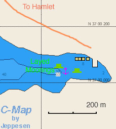
This is the cove recommended by the pilot books. It has a small pier which is used by the fishermen. With strong westerly winds there is enough fetch across the bay to make it uncomfortable. The bottom is littered with debris that can foul the anchor. Be prepared for dragging. In 1999 Mr. Kamposos installed several permanent moorings which make life much easier. He does however charge a fee (€ 7 in 2008). |
North Cove
| GPS: 37°0.17′N, 26°27.78′E
This small cove is just about 1/2 nM W of the East Cove and is very well sheltered form the westerlies but it is open to the S wind. Drop the anchor as close as possible to the NE corner and back to the S. Then take a long line (about 80 m) from the bow to the W shore. I weathered in 1998 a force 8 gale in this cove. --Istioploos 18:32, 3 November 2008 (UTC) There is a path at the NE of the cove that leads to the hamlet and to the East Cove. |
West Cove
| GPS: 36°59.88′N, 26°27.14′E
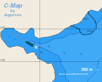
This is also a very attractive cove. Very clean but more subject to WNW gusts than the North Cove. It should be better protected from the S. wind. |
Vathi
| GPS: 36°59.97′N, 26°26.22′E
According to Heikell, this cove is protected from the meltemi. But it does not look after all to be a very good anchorage because of its great depths.
|
Offshore Islands
Kinaros
| GPS: 36°58.4′N, 26°17.4′E
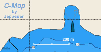
There is only one cove in the small island of Kínaros (Κύναρος). It looks like a very good place and well sheltered from the northerly meltemi. There is only a single house here. The cove is narrow and one has to anchor in about 5 m depth and maybe take two lines ashore to keep the boat from drifting to the rocks. |
Tourism & things to do ashore
The Kambosos family hamlet is neat and worth seeing, other than that there is not much to do in Levitha other then some walks. There are some ruins on the S side of the island that could be Hellenistic.
Fuel, Water, & Electricity
N/A.
Laundry
N/A.
Grocery & Supply Stores
None.
Eateries
There is a small restaurant at the hamlet which only operates in the summer, however the food here, although simple, is outstanding. Mrs. Irene, her husband Dimitris, and her sons Tassos, and Manolis are very hospitable. They can be contacted at +30 22470 23304 and VHF channel 09.
Internet/WiFi
Available?
Motorbike & Car Rentals
N/A.
Marine Stores & Facilities
None.
Repairs
N/A.
Garbage Disposal
N/A.
Transportation
N/A.
Routes/Passages To/From
Popular passages/routes, timing, etc.
References & Publications
See Greece.
Cruiser's Friends
Contact details of "Cruiser's Friends" that can be contacted for local information or assistance.
Forum Discussions
List links to discussion threads on the Cruiser Log Forum
External Links
Links to relevant websites.
Personal Notes
Personal experiences?
Last Visited & Details Checked (and updated here)
Date of member's visit to this Port/Stop & this page's details validated:
- September 2008 --Istioploos 18:32, 3 November 2008 (UTC)
| |
|---|
| | HOMEPAGE | Wiki Contents | Mediterranean | Aegean Sea | Greece | Levitha and Kinaros | |
.
