Lignano Riviera
From CruisersWiki
Lignano Riviera, Italy
| | |
| | 45°38.33′N, 13°06.43′E |
|---|---|
| | [ Photo gallery] |
| | [ Local chartlet] |
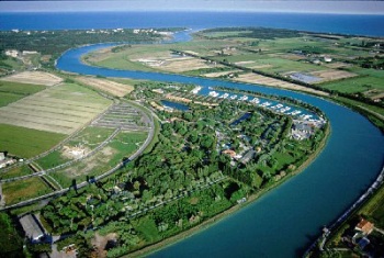
The Lignano Riviera describes the stretch of Adriatic coastline between the entrance to the Tagliamento river 37 miles NE of Venice and the entrance to the Laguna di Marano at the port of Lignano five miles further NE. In this section it refers to the berths in the river Tagliamento itself, which is accessed via a shallow channel with minimum depths of 2.7 metres, albeit subject to silting in winter storms. It is wise to check the current depths before attempting to enter, especially in early season or after severe storms, as sandbanks can form after winter floods or onshore gales. Under no circumstances should the entrance be attempted in strong onshore winds. Yachts of moderate draft which enter the river have a choice of two marinas, the Marina Uno and Marina Punta Verde, which have a total of 690 berths for yachts up to 20 metres in depths of 2.0 - 3.0 metres.
Charts
British Admiralty 204
Italian charts 924, 39
Radio Nets
Also see World Cruiser's Nets
Local Weather
During the summer months the prevailing winds in the Adriatic are light to moderate coastal seabreezes. In spring and autumn, northerly winds are more frequent and can quickly rise to near gale force, especially in the northern Adriatic, where the much-feared “bora” is caused by high pressure over the mountains to the NE coupled with low pressure over southern Italy. Fortunately, the fiercest “bora” is normally to be expected in the winter months. Thunderstorms are occasionally experienced in spring and especially autumn and can be accompanied by violent winds of gale force and above. Luckily they are rarely long-lasting.
Sources for weather information:
- There is a continuous (computerised voice) weather forecast on VHF 68 - first in Italian and then followed with an English translation.
- The same forecast is given in Italian and English on VHF coastal stations following a notification on channel 16.
- Navtex weather forecasts covering the Adriatic are broadcast from stations at Roma, Trieste, Kerkyra (Greece) and Split (Croatia).
The entrance to the river Tagliamento lies at ![]() 45°38.33′N, 13°06.43′E. The entrance is prone to silting and depths are currently (January 2011) around 2.7 - 3.0 metres at low water. Entry should therefore only be attempted close to high water and on a rising tide and never in strong onshore winds. Access is along a 600-metre channel marked with pairs of marker posts. For access to the marinas, see respective entries.
45°38.33′N, 13°06.43′E. The entrance is prone to silting and depths are currently (January 2011) around 2.7 - 3.0 metres at low water. Entry should therefore only be attempted close to high water and on a rising tide and never in strong onshore winds. Access is along a 600-metre channel marked with pairs of marker posts. For access to the marinas, see respective entries.
Check-in facilities (for Customs and Immigration)
There are two berthing options in the river, Marina Uno with 420 berths for yachts up to 18 metres in depths of 2.0 - 3.0 metres, and the Marina Punta Verde further upstream with 270 berths for yachts up to 20 metres in similar depths of 2.0 - 3.0 metres. Click on the appropriate link for details.
Offshore Islands and Groups
None.
Marinas & Yacht Clubs
See above.
Anchorages
Anchoring in the river is prohibited.
Yacht Repairs and Services
Marine Stores
Submit addresses and contact details of marine related businesses that are of interest to cruisers.
Repairs/Yards
See marina entries for details
Fuel, Water, & Electricity
Fuel station in Marina Uno. None in Marina Punta Verde.
Tourism and Things to do Ashore
Tourism
The main attractions of the area are the beaches on the Adriatic coast and a golf club, but there is little else.
Grocery & Supply Stores
Minimarket in Marina Punta Verde.
Eateries
Restaurants and bars near both marinas.
Internet/WiFi
At Marina Punta Verde.
Laundry
None.
Motorbike & Car Rentals
Rental outlets in Lignano (5 kms).
Garbage Disposal
Bins at the marinas.
Transportation
Routes/Passages To/From
Popular passages/routes, timing, etc.
Cruiser's Friends
Contact details of "Cruiser's Friends" that can be contacted for local information or assistance.
Forum Discussions
List links to discussion threads on partnering forums. (see link for requirements)
External Links
Links to relevant websites.
References & Publications
Publications, Guides, etc.
Last Visited & Details Checked (and updated here)
Date of member's visit to this Port/Stop & this page's details validated:
- Data compiled from web research (please update if possible)--Athene of Lymington 17:26, 27 January 2011 (UTC)
Personal Notes
Personal experiences?
| |
|---|
| | HOMEPAGE | Wiki Contents | Mediterranean | Italy | Taranto | |
.
