Martinique
From CruisersWiki
MARTINIQUE CRUISING GUIDE
| Martinique | |
 Martinique | |
 Flag | |
| Capital: | Fort-de-France |
|---|---|
| Language: | French, Creole patois |
| Currency: | Euro |
| More notes about the country | |
Background
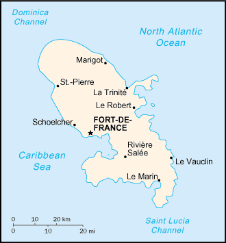
Martinique is a province of France. It is part of the French Antilles and the most northerly of the Windwards Caribbean islands. Martinique has an area of 1,128 km2 and a population of 432.900. It is very mountainous and green. There are two volcanoes, the tallest Mount-Pelée is still active and on May 8 1902 it erupted destroying the then capital of the island, of St. Pierre, killing over 30,000 people.
Martinique was colonized by France in 1635 and in 1946 became a prefecture (province) of France. It is the birthplace of Empress Josephine the wife of Napoleon Bonaparte.
In the summer months Martinique, June to October, is very humid and uncomfortable.
Charts
Submit the chart details that are required for safe navigation.
Radio Nets
Also see Cruiser's Nets
Submit details of local radio Nets.
Warning: The approach into the Cul-de-Sac du Marin lagoon is very tricky to navigate because one must follow a channel that snakes around reefs and shallow sand bars. This channel is well marked but to make it even more challenging it uses the buoys in the American IALA B system (red right returning) which is the opposite of the IALA A used by the rest of the world. That is you must keep a red marker to your starboard instead of to your port.
Check-in facilities
The main yacht harbor in the island is Cul-de-Sac du Marin but there many coves and bays. It is a large landlocked lagoon with many coves. It is considered an excellent hurricane hole. The main commercial harbor is Fort-de-France.
Warning: Here as in all of the Caribbean dinghy theft is endemic. Always lock your dingy when going ashore, even within the marina.
Ports and Popular Stops
- Fort-de-France (Commercial Port) (Port of entry)
- Cul-de-Sac du Marin (Port of entry)
- Anse Mitan (Port of entry)
- St Pierre (Port of entry)
Marinas & Yacht Clubs
Anchorages
Sainte Anne
Sainte Anne [14° 26.3' N 60° 53.1' W] is a very attractive anchorage just 6 M from the marina. Anchor across from the little town at 5 m depth over sand, good holding. It easy to go to the town with the dinghy which you can tie at the little dock. Good provisions. Fresh bread!
Other Anchorages in Cul-de-Sac du Marin
There many anchorages within Cul-de-Sac du Marin. This section need further additions.
Others
There many anchorages in the island. This section need further additions.
Offshore Islands
List Islands
Routes/Passages To/From
Popular passages/routes, timing, etc.
Tourism & things to do ashore
List places of interest, tours, eateries, etc.
Marine stores
Submit addresses and contact details of marine related businesses that are of interest to cruisers.
References & Publications
Publications, Guides, etc.
Cruiser's Friends
Contact details of "Cruiser's Friends" that can be contacted for local information or assistance.
Forum Discussions
List links to discussion threads on the Cruiser Log Forum
External Links
Links to relevant websites.
Personal Notes
Personal experiences?
.

