Meganisi
From CruisersWiki
m (Text replace - "BA " to "BA") |
m (Text replace - "{| class="infobox bordered" style="width: 33em; text-align: left; font-size: 85%;" " to "{| class="infobox bordered" style="width: 28em; text-align: left; font-size: 90%;"") |
||
| Line 1: | Line 1: | ||
==Meganisi== | ==Meganisi== | ||
| - | {| class="infobox bordered" style="width: | + | {| class="infobox bordered" style="width: 28em; text-align: left; font-size: 90%;"|- |
| - | |- | + | |
| colspan="2" style="text-align:center; font-size: smaller;" | {{Small info}} (''Click links for more information'') | | colspan="2" style="text-align:center; font-size: smaller;" | {{Small info}} (''Click links for more information'') | ||
|- | |- | ||
Revision as of 20:09, 15 June 2011
Meganisi
| | |
| | 38°39.73′N, 20°45.67′E |
|---|---|
| | Photo gallery |
| | Local chartlet |
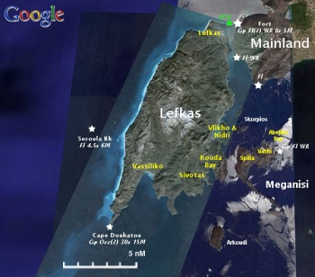
Meganisi (Μεγανήσι) is an island southeast of Lefkas. There are about 2000 inhabitants on the island most of them in the village Spartachori.
There are many nice coves in Meganisi.
Charts
- BA
- 189 Nisos Sapiénza to Nisos Paxoi
- 203 Zakinthos to Paxoi
- Imray-Tetra
- G11 Nísos Kérkira to Nísos Levkas
- NIMA
- 54280 Corfu Channel to Nisis Proti
- Greek
- 2 Ionio Pelagos
- 21 Ionio Sea - Northern Part Othonoi I. to Zakynthos I.
Radio Nets
Also see Cruiser's Nets
- Coast Guard - VHF channel 12
Weather
- See Ionian Sea Weather
- Also see Ionian Sea Currents & Tides
There are no dangers approaching Meganisisi.
Check-in facilities
None.
Ports and Popular Stops
Ports
Port Spilia
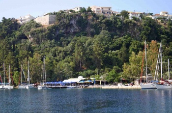
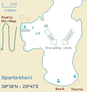
Port Spilia is an anchorage underneath the picturesque village of Spartachori. The busy taverna under the village has its own quay with laid moorings. |
Port Vathi
![]() 38°39.87′N, 20°46.95′E
38°39.87′N, 20°46.95′E
Port Vathi is E of Port Spilia and it is where the ferry from Nidri, Lefkas islands.
There is a new wall that extends from the Western shore, to make a large new harbour. Signs of major new investment in shore power and water boxes on the quay (not yet working in September 2009). Several restaurants and minimarkets.
To the east of Port Vathi there are many nice anchorages.
Anchorages
Port Atheni
![]() 38°39.82′N, 20°47.94′E
38°39.82′N, 20°47.94′E
Port Atheni is a nice cove east of Port Vathi. Anchor on the west side of the cove.
Abelike Bay
![]() 38°39.96′N, 20°47.4′E
38°39.96′N, 20°47.4′E
Abelike Bay is a most beautiful and secluded anchorage on the NE of the island (east of Port Vathi & west of Port Atheni).
Anchor near the head of the bay and take a line ashore.
Marinas & Yacht Clubs
None.
Yacht Services and Repairs
Marine Stores
None.
Yacht Services/Repairs/Yards
None.
Fuel, Water, & Electricity
- Fuel
- N/A (Not Available)
- Water
- N/A
- Electricity
- N/A
Offshore Islands
Tourism and Things to do Ashore
Tourism
A walk to Spathochori is very pleasant and fun.
Grocery & Supply Stores
Limited provisions in Spathochori (Port Spilia).
Eateries
Internet/WiFi
Available?
Laundry
N/A (Not Available)
Motorbike & Car Rentals
N/A.
Garbage Disposal
?
Transportation
Ferries from Port Vathi to Nidri in Lefkas.
Routes/Passages To/From
Cruiser's Friends
Contact details of "Cruiser's Friends" that can be contacted for local information or assistance.
Forum Discussions
List links to discussion threads on partnering forums. (see link for requirements)
External Links
- Meganisi (Wikipedia)
References & Publications
See Ionian Sea.
Last Visited & Details Checked (and updated here)
Date of member's visit to this Port/Stop & this page's details validated:
- July 1988 --Istioploos

- June 2005 --Atheneoflymington 17:42, 12 January 2010 (UTC)
Personal Notes
Personal experiences?
|
|---|
|
Names: |
| |
|---|
| | HOMEPAGE | Wiki Contents | Mediterranean | Ionian Sea | Greece | Meganisi | |
.


