Newton Haven
From CruisersWiki
(→Offshore Islands and Groups) |
|||
| Line 21: | Line 21: | ||
==Local Weather== | ==Local Weather== | ||
| - | |||
| - | + | See [[Amble]] for local weather details. | |
| - | + | ||
| - | + | ||
==Charts== | ==Charts== | ||
| Line 62: | Line 59: | ||
Anchor on the second leading line in 3 meters of water. The sea bed is sand and the holding good. | Anchor on the second leading line in 3 meters of water. The sea bed is sand and the holding good. | ||
| - | |||
| - | |||
| - | |||
| - | |||
| - | |||
| - | |||
| - | |||
| - | |||
| - | |||
| - | |||
| - | |||
| - | |||
====Fuel, Water, & Electricity==== | ====Fuel, Water, & Electricity==== | ||
| Line 85: | Line 70: | ||
==Things to do Ashore== | ==Things to do Ashore== | ||
====Tourism==== | ====Tourism==== | ||
| - | + | ||
| - | * | + | * [http://en.wikipedia.org/wiki/Dunstanburgh_Castle Dunstanburgh Castle] is a 2 mile walk to the south. |
| - | * | + | * [http://en.wikipedia.org/wiki/Craster Craster] is a 3 mile walk to the south. |
====Grocery & Supply Stores==== | ====Grocery & Supply Stores==== | ||
| Line 154: | Line 139: | ||
====Last Visited & Details Checked (and updated here)==== | ====Last Visited & Details Checked (and updated here)==== | ||
''Date of member's visit to this Port/Stop & this page's details validated'': | ''Date of member's visit to this Port/Stop & this page's details validated'': | ||
| - | * | + | * [[User:Richgmorg|Richgmorg]] visited 18/4/2014 |
* | * | ||
Revision as of 00:20, 20 April 2014
Newton Haven Cruising Guide
Newton Haven (also known as St. Marys Haven or Low Newton by the Sea) is a fabulous anchorage when the wind is from the right direction (NW through W to S) and their is little swell. The drying rocks to the East (Fills Rock) provide shelter from all but a North Easterly swell on the bottom half of the tide, but they are covered on the top half of the tide and a second anchor to prevent you lying sideways on to the swell is recommended.
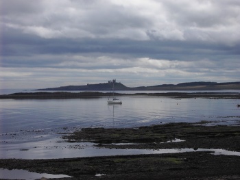
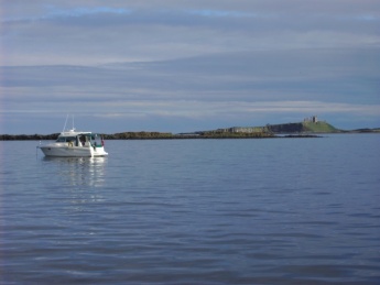
The anchorage is very picturesque with views of Dunstanburgh castle to the South, a cluster of houses around a small green and an excellent pub called "The Ship Inn".
| | |
| | 55°30.86′N, 1°36.68′W |
|---|---|
| | Photo gallery |
| | Local chartlet |
 Newton Haven from the North Newton Haven from the North
| |
Local Weather
See Amble for local weather details.
Charts
There are no good charts which cover this anchorage in details, but Google maps satellite image gives an excellent idea of the layout of the anchorage.
- British Admiralty
- 1627
Radio Nets
Also see World Cruiser's Nets.
Newton Haven lies to the south of a prominent radio mast. Newton point can also be identified by a smaller radio tower.
Approaching from the north, keep to seaward of the Newton Rock port hand lateral marker and continue south towards Dunstanburgh Castle until the first leading line into the anchorage is identified. Take care not to turn east before the leading line since the are several rocks to the south west of the lateral marker.
From the south, clear the point off Dunstanburgh castle and keep heading north towards the Newton Rock port hand lateral marker until the first leading line into the anchorage is identified.
The first leading line is the line of the roof (or chimneys) of the houses to the south of the Low Newton green. This line clears both Fills Rock to the South and also the rock to the south of Newton point (this rock can be clearly seen as a breaking wave on the Google maps image). Keep on this line until the second leading line to the south is identified.
The second leading line is the keep of Dunstanburgh Castle in line with the most westerly non covering part of Emblestone Rocks. These are the prominent band of rocks that protect the southern part of the anchorage. Follow this line south and anchor in 3 - 4 meters of water or as far south as your draught and the tide allows.
Alternative anchorages are available for boats with local knowledge that can take the ground. The first of these lies on the beach, inshore of the local moorings and boats, taking care to avoid the rocks in the north west corner of the beach. The second lies in the south west corner close to Emblestone Rocks.
On the top half of the tide it is also possible to enter the anchorage at the south eastern end via a cut between Fills Rock and Embleston Rock. There is no obvious leading line or marks for this cut and local knowledge is therefore essential.
Berthing Options
The only option for visitors is to anchor, although some private small craft moorings exist inshore of the anchorage.
Anchorage
Anchor on the second leading line in 3 meters of water. The sea bed is sand and the holding good.
Fuel, Water, & Electricity
- Fuel
- None
- Water
- There is a tap in the middle of the holiday houses in the dunes.
- Electricity
- None
Things to do Ashore
Tourism
- Dunstanburgh Castle is a 2 mile walk to the south.
- Craster is a 3 mile walk to the south.
Grocery & Supply Stores
Eateries
- The Ship Inn
Internet/WiFi
Available?
Laundry
Motorbike & Car Rentals
Garbage Disposal
There is a bin at the road side.
Transportation
List transportation (local and/or international.)
Routes/Passages To/From
List popular passages/routes, timing, etc.
Cruiser's Friends
Contact details of "Cruiser's Friends" that can be contacted for local information or assistance.
Forum Discussions
List links to discussion threads on partnering forums. (see link for requirements)
External Links
List links external to the wiki such as in Wikepedia.
References & Publications
Books, Guides, etc. Use the Reference template or not at your discretion. For example:
-
{{Reference|Rod Heikel|Greek Waters Pilot|Imray Laurie and Wilson, Cambridgeshire|9780852889718}}, expands to - Rod Heikell, Greek Waters Pilot Imray, Laurie and Wilson, Cambridgeshire, ISBN 9780852889718
- Author, Title, Publisher, ISBN ISBN number
- Author, Title, Publisher, ISBN ISBN number
You may want to remove the above entries and use instead a link to the Country or Region that lists the relevant references. If so enter, after removing {{MagentaText|xx}}, the following:
See [[Country or Region#References_&_Publications|Coutry or Region]].
If you do not use the above link, please remove it.
Personal Notes
Personal experiences?
Last Visited & Details Checked (and updated here)
Date of member's visit to this Port/Stop & this page's details validated:
- Richgmorg visited 18/4/2014
If you provide a lot of info and this page is almost complete, change to {{Guide2}}.
|
|---|
|
Names: Istioploos Richgmorg |
Add all the pages that are "parent" to this one.
| |
|---|
| | HOMEPAGE | Wiki Contents | United Kingdom | England | Amble | Newton Haven | |
{GreenText|If any ports or anchorages are described in this page keep the items below, otherwise delete them.}}
