Phuket
From CruisersWiki
Lighthouse (Talk | contribs) (→Anchorages) |
Lighthouse (Talk | contribs) (→Anchorages) |
||
| Line 14: | Line 14: | ||
===Anchorages=== | ===Anchorages=== | ||
| - | |||
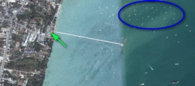
[[Image:Au_Cha_Long.jpg|right|thumb|400px|Ao Chalong]] | [[Image:Au_Cha_Long.jpg|right|thumb|400px|Ao Chalong]] | ||
| + | '''Ao Chalong'''. | ||
| + | |||
A huge shallow anchorage on the South East Coast of Phuket Island.<br> | A huge shallow anchorage on the South East Coast of Phuket Island.<br> | ||
At 7° 49' 22.12" North 98°20' 59.1" | At 7° 49' 22.12" North 98°20' 59.1" | ||
| Line 24: | Line 25: | ||
Holding is sticky grey clay mud - Marine Dept Moorings are available for pick up - if used check by backing up on the mooring (some are suspect) | Holding is sticky grey clay mud - Marine Dept Moorings are available for pick up - if used check by backing up on the mooring (some are suspect) | ||
| - | |||
| - | |||
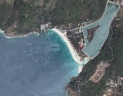
[[Image:Nai_Hahn_Bay.jpg|right|thumb|250px|Nai Hahn Bay]] | [[Image:Nai_Hahn_Bay.jpg|right|thumb|250px|Nai Hahn Bay]] | ||
| + | '''Nai Harn''' | ||
A sheltered bay from the North East monsoon<br> | A sheltered bay from the North East monsoon<br> | ||
| Line 36: | Line 36: | ||
During the Great Tsunami a large number of yachts were in this bay waiting to head off to the Red sea and beyond - fortunately they were all anchored well off shore so that when the Tsunami struck no yacht was taken, all rising and falling with the wave passing under. On shore a lot a damage - a lot of people drowned. | During the Great Tsunami a large number of yachts were in this bay waiting to head off to the Red sea and beyond - fortunately they were all anchored well off shore so that when the Tsunami struck no yacht was taken, all rising and falling with the wave passing under. On shore a lot a damage - a lot of people drowned. | ||
| - | |||
| - | |||
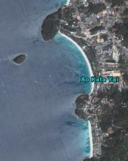
| - | [[Image:Kata_Bays_- | + | [[Image:Kata_Bays_-_Sat_Pics.jpg|right|thumb|250px|Kata North & South]] |
| + | '''Kata North and South'''. | ||
2 bays open to the South West - not suitable for anchoring during the S.W. Monsoon.<br> | 2 bays open to the South West - not suitable for anchoring during the S.W. Monsoon.<br> | ||
| Line 45: | Line 44: | ||
'''Note''', this bay in the South West Monsoon gives no protection. | '''Note''', this bay in the South West Monsoon gives no protection. | ||
| - | |||
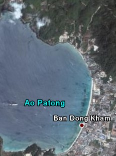
| + | [[Image:Pathong Bay.jpg|right|thumb|250px|Patong]] | ||
'''Patong'''. | '''Patong'''. | ||
| - | |||
| - | |||
Bay open to the South West - not suitable for anchoring during the S.W. Monsoon.<br> | Bay open to the South West - not suitable for anchoring during the S.W. Monsoon.<br> | ||
Revision as of 16:24, 7 October 2007
Contents |
PHUKET
Charts
Thai chart 308
Check-in facilities
Ao Chalong is the main clearing in/out destination on the West coast of Thailand
Marinas
Anchorages
Ao Chalong.
A huge shallow anchorage on the South East Coast of Phuket Island.
At 7° 49' 22.12" North 98°20' 59.1"
In the Sat picture note the blue Elipse - shows moorings for monohulls with medium to deep draft keels. the Green Arrow points to Immigration - Customs - Port Captain
Note:- Au Cha Long is the main clearing in/out destination on the West coast of Thailand
Holding is sticky grey clay mud - Marine Dept Moorings are available for pick up - if used check by backing up on the mooring (some are suspect)
Nai Harn
A sheltered bay from the North East monsoon
At 7° 46' 29.37" North 98° 18' 10.17"
Note, this bay in the South West Monsoon gives no protection.
The surf at high tide ensures a fast ride to the beach - beware. Every year a number of tourists are drowned.
During the Great Tsunami a large number of yachts were in this bay waiting to head off to the Red sea and beyond - fortunately they were all anchored well off shore so that when the Tsunami struck no yacht was taken, all rising and falling with the wave passing under. On shore a lot a damage - a lot of people drowned.
Kata North and South.
2 bays open to the South West - not suitable for anchoring during the S.W. Monsoon.
At 7° 49' 05.51" North 98° 17' 35.41"
Note, this bay in the South West Monsoon gives no protection.
Patong.
Bay open to the South West - not suitable for anchoring during the S.W. Monsoon.
At 7° 54' 10.68" North 98° 17' 10.20"
Offshore Islands
- Simillian Islands
Exploring Phuket Waters
- Phang Nga Bay
- Phuket to Langkawi
Things to do ashore
List places of interest, tours, eateries, etc.
Forum Discussions
List links to discussion threads on the Cruiser Log Forum
Marine stores
Submit addresses and contact details of marine related businesses that are of interest to cruisers.
References
Publications, etc.
External Links
Links to relevant websites.


