Portovenere
From CruisersWiki
m (bot: Move Communication) |
m (Text replace - "#References & Publications|" to "#References|") |
||
| (3 intermediate revisions not shown) | |||
| Line 1: | Line 1: | ||
{{IsPartOf|Mediterranean|Italy|Ligurian Coast}} | {{IsPartOf|Mediterranean|Italy|Ligurian Coast}} | ||
{{TOC block}} | {{TOC block}} | ||
| - | |||
| - | |||
| - | |||
| - | |||
| - | |||
| - | |||
| - | The small harbour of Portovenere lies at the western entrance to the gulf of La Spezia on the Ligurian coast of Italy, on the E side of the promontory of Punta San Pietro opposite the island of Palmaria. Originally a fishing settlement during the Roman era, it was later fortified by the Genoese as a naval base in the 12th century. Lord Byron, the notorious English poet, once swam across the Gulf of La Spezia from here to the town of Lerici, a distance of over four miles. Today, its picturesque harbour provides moorings for around 30 yachts along its quays. It is invariably busy during the summer months and a yacht may need to anchor off in the bay or at Isola Palmaria. | + | {{Infobox |
| + | | lat= 44.05093| lon=9.83645 | ||
| + | | name= Portovenere | ||
| + | | portofentry= | ||
| + | | zoom= 16 | ||
| + | | chartlet = y | ||
| + | | image= PortovenereHarbour.jpg | ||
| + | | imagetext= Portovenere harbour | ||
| + | | summary= The small harbour of Portovenere lies at the western entrance to the gulf of La Spezia on the Ligurian coast of Italy, on the E side of the promontory of Punta San Pietro opposite the island of Palmaria. Originally a fishing settlement during the Roman era, it was later fortified by the Genoese as a naval base in the 12th century. Lord Byron, the notorious English poet, once swam across the Gulf of La Spezia from here to the town of Lerici, a distance of over four miles. Today, its picturesque harbour provides moorings for around 30 yachts along its quays. It is invariably busy during the summer months and a yacht may need to anchor off in the bay or at Isola Palmaria. | ||
| + | | notes= | ||
| + | | news= | ||
| + | }} | ||
==Charts== | ==Charts== | ||
| Line 19: | Line 24: | ||
==Weather== | ==Weather== | ||
| - | The prevailing winds along the western part of the Ligurian coast during the summer are a SW or SE | + | The prevailing winds along the western part of the Ligurian coast during the summer are a SW or SE sea breeze, which rarely gets up much above force 4-5. Along the eastern part of the coast, the winds tend to come more from W or NW and are again usually little more than moderate. While infrequent, gales are not unknown during the spring and early summer and are typically caused by depressions further west in the Golfe du Lion which bring strong N winds as they move further E. In winter, the ''tramontana'', a strong N wind off the Alps, is more frequent, although the ''libecchio'' is a strong SW wind that can affect the whole of the Ligurian coast and blow for several days, causing heavy seas. |
Sources for weather forecasts: | Sources for weather forecasts: | ||
| - | * There is a continuous ( | + | * There is a continuous (computerized voice) weather forecast on VHF 68 - first in Italian and then followed with an English translation |
* The same forecast is given in Italian and English on VHF coastal stations following a notification on channel 16 | * The same forecast is given in Italian and English on VHF coastal stations following a notification on channel 16 | ||
* Navtex weather forecasts are broadcast from stations at La Garde (Toulon), Roma and Cagliari (Sardinia) | * Navtex weather forecasts are broadcast from stations at La Garde (Toulon), Roma and Cagliari (Sardinia) | ||
==Passages== | ==Passages== | ||
| - | + | ''See [[Mediterranean#Mediterranean_Passages|Mediterranean]]''. | |
| - | + | ||
==Islands== | ==Islands== | ||
| Line 35: | Line 39: | ||
==Communication== | ==Communication== | ||
| + | {{Green|Add here VHF channel for the coastguard, harbor masters. etc.}} | ||
* | * | ||
* | * | ||
| Line 44: | Line 49: | ||
==Berthing== | ==Berthing== | ||
| - | + | The harbour is operated as a marina. | |
| - | + | ||
===Marinas & Yacht Clubs=== | ===Marinas & Yacht Clubs=== | ||
| - | + | {{poi | lat= 44.05108 |lon=9.83565 | |
| + | | type= marina | ||
| + | | name= Portovenere Marina | ||
| + | | altname= | ||
| + | | url = http://www.portodiportovenere.it/servizi-portovenere_2.asp?id_lingue=2&sez=portovenere | ||
| + | | zoom= 17 | ||
| + | | portofentry= | ||
| + | | image= | ||
| + | | imagetext= | ||
| + | | text= A Blue Flag small marina with 32 moorings in the harbour, of which just six are designated for yachts in transit (the pontoons to the N of the harbour are for local residents only). Maximum length 50 metres. Depths in the harbour range from 2.0 to 4.0 metres. Depths shallow to just 1.0 metre off the beach. Shelter in the harbour is good. Toilets and showers. Scuba diver. Water, electricity,toilets and showers. Free WiFi. 5 tonnes grue. The crane can be used in summer by 10.00 am, as the whole area is a limited traffic zone. Good shelter! | ||
| - | + | {{Note}}You must book a berth in advance. | |
| - | + | : {{email|porto@portodiportovenere.it}}; Tel/Fax: {{phone|39|0187|793042}}; VHF channel 09 | |
| - | + | }} | |
| - | == | + | ==Anchorages== |
| - | + | The nearest safe anchorage is at Isola Palmaria, where a yacht can anchor in one of the bays on the N or E coast of the island, depending on wind direction. | |
| - | + | ||
| - | + | ||
| - | == | + | ==Amenities== |
| - | + | {{tlist | |
| - | + | |header|Facilities | |
| - | + | ||
| - | + | |Water| In [[#Portovenere Marina|Portovenere Marina]] | |
| - | + | |Electricity| In [[#Portovenere Marina|Portovenere Marina]] | |
| - | [[ | + | |Toilets| In [[#Portovenere Marina|Portovenere Marina]] |
| - | [[ | + | |Showers| In [[#Portovenere Marina|Portovenere Marina]] |
| + | |Laundry| {{MagentaText|?}} | ||
| + | |Garbage| Bins near the harbour | ||
| - | + | |header|Supplies | |
| + | |Fuel| Fuel in the town only, must carry. | ||
| + | |Bottled gas| {{MagentaText|?}} | ||
| + | |Chandlers| {{MagentaText|?}} | ||
| - | + | |header|Services | |
| - | + | |Repairs| Limited repairs. Fixed crane (5 T) | |
| - | + | |Internet| Free WiFi in [[#Portovenere Marina|Portovenere Marina]] | |
| + | |Mobile connectivity| {{MagentaText|?}} | ||
| + | |Vehicle rentals| {{MagentaText|?}} | ||
| + | }} | ||
| - | == | + | ==Provisioning== |
| - | + | Reasonable provisions in the town. | |
| - | + | ||
| - | == | + | ==Eating out== |
| - | + | Several trattorias and bars along the waterfront and in the town. | |
| - | ==== | + | ==Transportation== |
| + | {{GreenText|List transportation (local and/or international.)}} | ||
* | * | ||
| - | |||
| - | |||
* | * | ||
| - | ==== | + | ==Tourism== |
| - | + | [[Image:PortovenereWaterfront.jpg|345px|thumb|right| '''Portovenere waterfront''']] | |
| + | [[Image:PortovenerePietro.jpg|345px|thumb|right| '''Church of San Pietro, Portovenere''' ]] | ||
| - | + | The small harbour, surrounded by tall, pastel-coloured houses, is extremely picturesque. The walk out to the historic church of San Pietro at the end of the promontory is a must. The church was built by the Genoese in the 13th century on the site of a former Roman temple to Venus (hence Portovenere). In the town, the Romanesque cathedral of San Lorenzo contains several notable works of art. Overlooking the town is the powerful fortress of Castello Doria, reminding the observer of the strategic importance of the town in earlier times. | |
| - | + | ||
| - | + | ||
==Friends== | ==Friends== | ||
| Line 109: | Line 124: | ||
* | * | ||
| - | ==References | + | ==References== |
| - | ''See [[Italy#References | + | ''See [[Italy#References|Italy]]''. |
| - | {{Comments | + | {{Comments}} |
| + | * | ||
{{Verified by}} | {{Verified by}} | ||
| - | |||
* Data compiled from web research (please update if possible)--[[User:Atheneoflymington|Athene of Lymington]] 12:14, 1 December 2010 (UTC) | * Data compiled from web research (please update if possible)--[[User:Atheneoflymington|Athene of Lymington]] 12:14, 1 December 2010 (UTC) | ||
* | * | ||
| + | |||
| + | {{Green|If you provide a lot of info and this page is almost complete, change <nowiki>{{Page outline}} to {{Page useable}}</nowiki>.}} | ||
| Line 125: | Line 142: | ||
{{Contributors|[User:Atheneoflymington|Athene of Lymington]]}} | {{Contributors|[User:Atheneoflymington|Athene of Lymington]]}} | ||
| - | [[Category:Ports - Italy]] [[Category: | + | [[Category:Ports - Italy]] [[Category:Marinas - Italy]] [[Category:Anchorages - Italy]] [[Category:Islands - Italy]] |
Latest revision as of 07:57, 21 August 2018
| Portovenere
| |
| |
 Portovenere harbour |
The small harbour of Portovenere lies at the western entrance to the gulf of La Spezia on the Ligurian coast of Italy, on the E side of the promontory of Punta San Pietro opposite the island of Palmaria. Originally a fishing settlement during the Roman era, it was later fortified by the Genoese as a naval base in the 12th century. Lord Byron, the notorious English poet, once swam across the Gulf of La Spezia from here to the town of Lerici, a distance of over four miles. Today, its picturesque harbour provides moorings for around 30 yachts along its quays. It is invariably busy during the summer months and a yacht may need to anchor off in the bay or at Isola Palmaria.
Charts
- British Admiralty
- 1998 - Nice to Livorno
- Italian
- 909
- 115
- 3
Weather
The prevailing winds along the western part of the Ligurian coast during the summer are a SW or SE sea breeze, which rarely gets up much above force 4-5. Along the eastern part of the coast, the winds tend to come more from W or NW and are again usually little more than moderate. While infrequent, gales are not unknown during the spring and early summer and are typically caused by depressions further west in the Golfe du Lion which bring strong N winds as they move further E. In winter, the tramontana, a strong N wind off the Alps, is more frequent, although the libecchio is a strong SW wind that can affect the whole of the Ligurian coast and blow for several days, causing heavy seas.
Sources for weather forecasts:
- There is a continuous (computerized voice) weather forecast on VHF 68 - first in Italian and then followed with an English translation
- The same forecast is given in Italian and English on VHF coastal stations following a notification on channel 16
- Navtex weather forecasts are broadcast from stations at La Garde (Toulon), Roma and Cagliari (Sardinia)
Passages
See Mediterranean.
Islands
- Isola Palmaria
- Isola Tino
Communication
Add here VHF channel for the coastguard, harbor masters. etc.
Also see World Cruiser's Nets.
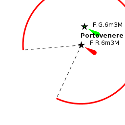
The harbour lies under a mile NE of the promontory of Punta San Pietro, on the end of which sits the conspicuous church of the same name. In calm weather, a yacht can pass through the channel between the promontory and the island of Palmaria immediately to the SE. Keep to the centre of the channel, where there are least depths of 4.0 metres at the NE end. Overhead cables pass over the channel, with a least height of 24 metres. The breakwaters of the harbour are visible where the channel opens out into the Gulf of La Spezia.
Berthing
The harbour is operated as a marina.
Marinas & Yacht Clubs
Portovenere Marina
A Blue Flag small marina with 32 moorings in the harbour, of which just six are designated for yachts in transit (the pontoons to the N of the harbour are for local residents only). Maximum length 50 metres. Depths in the harbour range from 2.0 to 4.0 metres. Depths shallow to just 1.0 metre off the beach. Shelter in the harbour is good. Toilets and showers. Scuba diver. Water, electricity,toilets and showers. Free WiFi. 5 tonnes grue. The crane can be used in summer by 10.00 am, as the whole area is a limited traffic zone. Good shelter!
Note: You must book a berth in advance.
- [email protected]; Tel/Fax: +39 (0187) 793042; VHF channel 09
Anchorages
The nearest safe anchorage is at Isola Palmaria, where a yacht can anchor in one of the bays on the N or E coast of the island, depending on wind direction.
Amenities
| Facilities | |
|---|---|
| Water | In Portovenere Marina |
| Electricity | In Portovenere Marina |
| Toilets | In Portovenere Marina |
| Showers | In Portovenere Marina |
| Laundry | ? |
| Garbage | Bins near the harbour |
| Supplies | |
| Fuel | Fuel in the town only, must carry. |
| Bottled gas | ? |
| Chandlers | ? |
| Services | |
| Repairs | Limited repairs. Fixed crane (5 T) |
| Internet | Free WiFi in Portovenere Marina |
| Mobile connectivity | ? |
| Vehicle rentals | ? |
Provisioning
Reasonable provisions in the town.
Eating out
Several trattorias and bars along the waterfront and in the town.
Transportation
List transportation (local and/or international.)
Tourism


The small harbour, surrounded by tall, pastel-coloured houses, is extremely picturesque. The walk out to the historic church of San Pietro at the end of the promontory is a must. The church was built by the Genoese in the 13th century on the site of a former Roman temple to Venus (hence Portovenere). In the town, the Romanesque cathedral of San Lorenzo contains several notable works of art. Overlooking the town is the powerful fortress of Castello Doria, reminding the observer of the strategic importance of the town in earlier times.
Friends
Contact details of "Cruiser's Friends" that can be contacted for local information or assistance.
Forums
List links to discussion threads on partnering forums. (see link for requirements)
Links
- Portovenere at the Wikipedia
References
See Italy.
Comments
We welcome users' contributions to the Wiki. Please click on Comments to view other users' comments, add your own personal experiences or recommend any changes to this page following your visit.
Verified by
Date of member's last visit to Portovenere and this page's details validated:
- Data compiled from web research (please update if possible)--Athene of Lymington 12:14, 1 December 2010 (UTC)
If you provide a lot of info and this page is almost complete, change {{Page outline}} to {{Page useable}}.
| This page has an outline in place but needs completing. Please contribute if you can to help it grow further. Click on Comments to suggest further content or alternatively, if you feel confident to edit this page, click on the edit tab at the top and enter your changes directly. |
| |
|---|
|
Names: [User:Atheneoflymington |