Poyrazkoy
From CruisersWiki
Poyrazkoy
Background
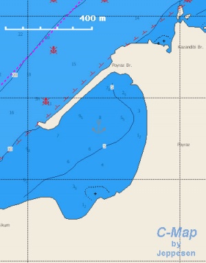
PoyrazKoy or simple Poyraz [41° 12.2' N 29° 07,.6' E] is located less than a mile from the Black Sea, on the Asian bank, is a good place to anchor especially when waiting for the fog to clear. It is also a pleasant place to spend the night before venturing out of the strait.
Charts
- BA 224 Maramara Denizi
- BA 1005 Marmara Adasi to Istanbul Boğazi
- NIMA 55040 Sea of Marmara
- Turkey 29 Marmara Sea
- Greek 109 Ionio-Aegeo Steno Messinis mechri Thalassa Marmara
Radio Nets
Also see Cruiser's Nets
- Bosphorus Control - VHF channels 11,12, & 13
Danger: Very often there is a heavy fog and the strait is closed to traffic. Always listen to Bosphorus Control on the VHF (channels 11,12, and 13).
Anchorages
Anchor behind the breakwater where convenient.
Routes/Passages To/From
Popular passages/routes, timing, etc.
Tourism & things to do ashore
List places of interest, tours, eateries, etc.
Marine stores
None.
References & Publications
See Turkey.
Cruiser's Friends
Contact details of "Cruiser's Friends" that can be contacted for local information or assistance.
Forum Discussions
List links to discussion threads on the Cruiser Log Forum
External Links
Links to relevant websites.
Personal Notes
Personal experiences?
Last Visited & Details Checked (and updated here)
Date of member's visit to this Port/Stop & this page's details validated:
- August 1999 --Istioploos 21:02, 9 December 2008 (UTC)
| |
|---|
| | HOMEPAGE | Wiki Contents | Mediterranean | Turkey | Bosphorus | Poyrazkoy | |
.
