Pučišća
From CruisersWiki
(New photos) |
m |
||
| Line 75: | Line 75: | ||
==Things to do Ashore== | ==Things to do Ashore== | ||
====Tourism==== | ====Tourism==== | ||
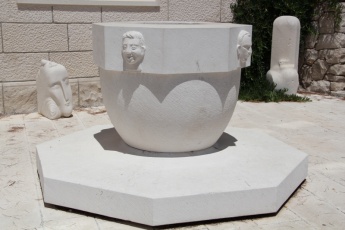
| - | [[Image: | + | [[Image:PucisceStoneArt.jpg|thumb|345px|right| '''A fine example of the Pucisca stonemason's craft''' <br />''Click for larger view'' ]] |
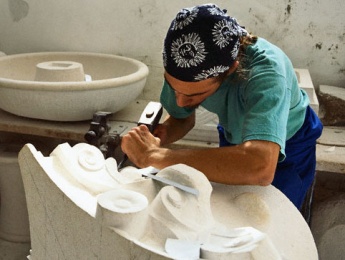
[[Image:PuciscaSculptor.jpg|thumb|345px|right| '''Pucisca stonemason at work''' <br />''Click for larger view'' ]] | [[Image:PuciscaSculptor.jpg|thumb|345px|right| '''Pucisca stonemason at work''' <br />''Click for larger view'' ]] | ||
The town is an important centre of the stone working industry and contains many fine examples of the stone mason’s craft, both in the form of the stone-built mansions that line many of the streets and the sculptures to be found in public spaces all round the town. There are several fine churches that bear testimony to the skills of Pucisca masons. The main school of stonemasonry on the island is to be found here on the N side of the harbour and there are usually several 'student' pieces to admire in front of it. | The town is an important centre of the stone working industry and contains many fine examples of the stone mason’s craft, both in the form of the stone-built mansions that line many of the streets and the sculptures to be found in public spaces all round the town. There are several fine churches that bear testimony to the skills of Pucisca masons. The main school of stonemasonry on the island is to be found here on the N side of the harbour and there are usually several 'student' pieces to admire in front of it. | ||
Revision as of 12:27, 9 July 2014
Pucisca, Croatia
| | |
| | 43°20.91′N, 16°44.61′E |
|---|---|
| | Photo gallery |
| | Local chartlet |
Click for larger view
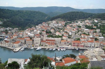
The small harbour of Pucisca is located on the NE coast of the island of Brac in Croatia, at the head of a deep inlet extending for nearly a mile inland. The entrance is three miles WNW of the bay of Povlja with its harbour and anchorage of U. Luka. The town was formerly an important centre for stonemasonry and there is still a stonemasons school here. Not surprisingly, the town boasts many fine old stone houses and the work of its stone sculptors is to be found in many of the town’s public places. The main yacht quay is in the W harbour and offers good shelter in most conditions for yachts of up to 15 metres, although it becomes almost untenable in the bora, which tends to blow from N directly down the inlet.
Charts
- British Admiralty
- 2712
- 1574
- Croatian charts
- MK18
- Imray
- M26 (Split to Dubrovnik)
Local Weather
Diurnal winds among the islands are mostly moderate during the summer months, predominantly from NW and rarely exceeding force 4/5, although gusting is common in narrow channels between islands and on the lee side of headlands. At night, katabatic winds off the mountains affect some of the islands close to the mainland coast. During early spring and (especially) autumn conditions can be more unsettled, occasionally accompanied by violent thunderstorms - luckily of short duration - with winds of 30-35 knots or more and vicious, steep seas. In the winter the sudden, violent N wind off the mountains, the bora, is much to be feared, especially along the coast from Rijeka down to Zadar, although its effects can be felt as far south as Split.
Equally prevalent in winter - although not uncommon in summer - is the scirocco, a S/SE wind that blows up from North Africa, usually in advance of a depression moving E across the Mediterranean. Unlike the bora, the scirocco only occasionally exceeds gale force, but is still a phenomenon to be wary of, especially if on a lee coast.
For sources of weather forecasting, see Croatia.
The immediate approach to Pucisca is free of dangers. The inlet is entered between the headland of Rt Sv Nikola on the W side, which is marked with a conspicuous light structure and Rt Pucisca on the E side, which is clearly identifiable from the large quarry and spoil heap on the shore. The harbour lies just under a mile up the inlet to starboard. Depths in the inlet are over 25 metres and in the harbour 3.0 - 5.0 metres. Shelter is good in most conditions, but poor with very strong N winds.
Check-in facilities (for Customs and Immigration)
Split is the nearest all-year round port of entry. During the summer, Hvar, Vis and, if arriving from N, Primosten on the mainland are also ports of entry.
Berthing options
There are two main berthing options for yachts visiting Pucisca harbour:
1. W. harbour
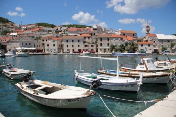
The W harbour consists of a basin partially protected by two short jetties and is the main harbour of the town. Around 20 moorings have been laid along the S side of the basin, some of which are occupied by local boats, leaving usually 8-10 available for visiting yachts. The mooring lines are not very long in view of the cramped nature of the harbour and they would not suit yachts of much over 15 metres – especially the ones towards the W end of the quay. Also, they are laid on something of a slant in view of the configuration of the harbour, which can be a bit disconcerting at first. Depths are around 3.5 – 4.0 metres along most of the quay. There is a small (stone-built, naturally) toilet and shower block near the quay on the breakwater (next to the rather smart garbage bins). Shelter is good on the quay in all but strong N and NE winds.
2. N. quay
It is possible to berth alongside the quay on the N side of the inlet, outside the short breakwater of the W harbour, although this is regularly used by tripper boats and space is often at a premium. It is, however, a useful spot to berth for a trip to the nearby Studenac supermarket. Depths are 4.0 – 5.0 metres, but there is very little to tie onto and you might have to use a stone lamppost base to secure your lines.
The smaller E basin ‘round the corner’ from the main harbour, which used to be an option for visiting yachts, is now full of small craft moorings and berthing here is no longer possible. This basin has, in any case, poorer protection from N and NE winds.
Marinas & Yacht Clubs
None.
Anchorages
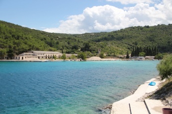
It is possible to anchor in the SE arm of the inlet, 500 metres E of the harbour, although it is quite industrial here and not particularly attractive. Anchor in 6.0 - 7.0 metres in the centre of the inlet. Holding is good in sand and mud. Shelter is good in most conditions, but it is the worst place to be with any fresh to strong N winds, which funnel straight in. An alternative anchorage, which offers better shelter with N winds, can be found at U. Luka, the westernmost inlet in Povla bay, two miles W of the town of Povlja. See Brac Island page for details.
Yacht Repairs and Services
None.
Fuel, Water, & Electricity
No fuel berth. Water and electricity on the quays in the W harbour.
Things to do Ashore
Tourism
The town is an important centre of the stone working industry and contains many fine examples of the stone mason’s craft, both in the form of the stone-built mansions that line many of the streets and the sculptures to be found in public spaces all round the town. There are several fine churches that bear testimony to the skills of Pucisca masons. The main school of stonemasonry on the island is to be found here on the N side of the harbour and there are usually several 'student' pieces to admire in front of it.
Grocery & Supply Stores
Several supermarkets, provisions shops and butchers in the town. Fruit and vegetable market.
Eateries
Numerous restaurants and café/bars ashore.
Internet/WiFi
From internet cafés only.
Laundry
None.
Motorbike & Car Rentals
None.
Garbage Disposal
Bins on the harbour breakwater.
Transport
- Buses to Supetar and other local destinations
Routes/Passages To/From
Cruiser's Friends
Contact details of "Cruiser's Friends" that can be contacted for local information or assistance.
Forum Discussions
List links to discussion threads on partnering forums. (see link for requirements)
External Links
Also see Croatia.
References & Publications
See Croatia.
Personal Notes
Personal experiences?
Last Visited & Details Checked (and updated here)
Date of member's visit to this Port/Stop & this page's details validated:
- July 2014 --Athene of Lymington
|
|---|
|
Names: Lighthouse, Athene of Lymington |
| |
|---|
| | HOMEPAGE | Wiki Contents | Croatia | Brac | Pucisca | |
