Rogoznica
From CruisersWiki
(→Berthing: dest) |
m |
||
| Line 167: | Line 167: | ||
{{Image right|DragonsEye.jpg |The Dragon’s Eye, Rogoznica}} | {{Image right|DragonsEye.jpg |The Dragon’s Eye, Rogoznica}} | ||
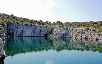
Rogoznica is an attractive village to explore, with several mediaeval churches and excellent views over the bay from its waterfront. The surrounding area has numerous coastal walks and tracks to explore among the thick pine forests along the coast. Behind the marina is an unusual sea water lake, Dragon’s Eye, formed by a collapsed sea cave. | Rogoznica is an attractive village to explore, with several mediaeval churches and excellent views over the bay from its waterfront. The surrounding area has numerous coastal walks and tracks to explore among the thick pine forests along the coast. Behind the marina is an unusual sea water lake, Dragon’s Eye, formed by a collapsed sea cave. | ||
| - | |||
| - | |||
| - | |||
| - | |||
| - | |||
| - | |||
| - | |||
| - | |||
| - | |||
==Links== | ==Links== | ||
Revision as of 18:49, 14 August 2018
| Rogoznica
| |
| | |
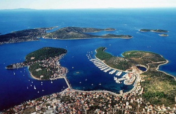
The harbour and marina of Rogoznica are situated on the Adriatic coast of Croatia, five miles SE of Primosten and 15 miles W of Trogir. Like many of the settlements along this coast, it was originally sited on an island and walled to defend it from Turkish and other invaders. In more recent times, the island was connected to the mainland by a causeway. Today Rogoznica is a popular tourist resort and, in view of its good shelter, a popular port of call for visiting yachts.
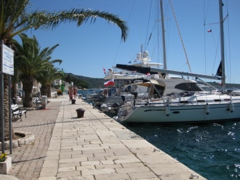
Cruisers have the option of mooring on the quay on the W side of Rogoznica island (where, however, depths are only about 2.0 metres), berthing in the 450-berth Marina Frapa, or picking up one of the 16 mooring buoys in the large bay to the E of Rogoznica island. Shelter is excellent in most parts of the bay, although the anchorage can become uncomfortable in strong southerlies, when the small village of Razanj at the southern end of the bay offers better shelter.
Charts
| British Admiralty | 2774 |
|---|---|
| Croatian | 100-21 |
| Imray | M25 |
Weather
Diurnal winds along the coast are mostly moderate during the summer months, predominantly from NW and rarely exceeding force 4/5. At night, katabatic winds off the mountains are a feature of some of the harbours along the NE Adriatic coast. During early spring and (especially) autumn conditions can be more unsettled, occasionally accompanied by violent thunderstorms - luckily of short duration - with winds of 30-35 knots or more and vicious, steep seas. In the winter the sudden, violent N wind off the mountains, the bora, is much to be feared, especially along the Velebitski channel. It tends to blow less strongly S of Zadar.
Equally prevalent in winter - although not uncommon in summer - is the scirocco, a S/SE wind that blows up from North Africa, usually in advance of a depression moving E across the Mediterranean. Unlike the bora, the scirocco only occasionally exceeds gale force, but is still a phenomenon to be wary of, especially if on a lee coast.
For sources of weather forecasting, see Croatia.
Passages
See Croatia.
Islands
Communication
Also see World Cruiser's Nets.
Other than the usual numerous small islets off the coast, there are no hazards in the approach to the bay of Rogoznica. After entering the bay, the island on which the village of Rogoznica stands will be clearly identifiable extending from the N shore into the bay. Turn to port, leaving the island to starboard, if you intend to berth in the marina or moor on the quay; if intending to pick up one of the mooring buoys or to anchor, turn to port after passing the island and proceed N into the large bay to the E of Rogoznica village.
Berthing
Town quay
- Marinas & Yacht Clubs
- Marina Frapa |
 – marina |
Anchorages
u. Soline
Rogoznička luka
Rogoznička luka
u. Ražanj
- Beyond the Rogoznička luka
u. Borovica
u. Sičenica
u. Stari Trogir
Amenities
| Facilities | |
|---|---|
| Water | in the marina and on the town quay |
| Electricity | in the marina and on the town quay |
| Toilets | in the marina |
| Showers | in the marina |
| Laundry | In the marina |
| Garbage | Bins in the marina |
| Supplies | |
| Fuel | Fuel station in the marina |
| Bottled gas | |
| Chandlers | |
| Services | |
| Repairs | |
| Internet | None |
| Mobile connectivity | |
| Vehicle rentals | Can be organized via the marina office. |
| Health | |
Provisioning
- Several provisions shops in the village.
- There is a good supermarket and market just to the north of the causeway easily accessed from boats anchored in the bay to the east of the causeway
Eating out
- Several restaurants in the marina.
- Others in the village.
- Konoba Mario on the waterfront opposite the yacht quay reportedly was is excellent.
Transportation
Buses E towards Split and W towards Šibenik
Tourism
Rogoznica is an attractive village to explore, with several mediaeval churches and excellent views over the bay from its waterfront. The surrounding area has numerous coastal walks and tracks to explore among the thick pine forests along the coast. Behind the marina is an unusual sea water lake, Dragon’s Eye, formed by a collapsed sea cave.
Links
- Rogoznica at the Wikipedia
For other useful websites, see Croatia.
References & Publications
See Croatia.
Comments
We welcome users' contributions to the Wiki. Please click on Comments to view other users' comments, add your own personal experiences or recommend any changes to this page following your visit.
Verified by
Date of member's last visit to Rogoznica and this page's details validated:
- May 2015 --Zebahdy of London
- June 2016 --Athene of Lymington
| This is a usable page of the cruising guide. However, please contribute if you can to help it grow further. Click on Comments to add your personal notes on this page or to discuss its contents. Alternatively, if you feel confident to edit the page, click on the edit tab at the top and enter your changes directly. |
| |
|---|
|
Names: Haiqu, Athene of Lymington |


