Saba
From CruisersWiki
(Difference between revisions)
m (Text replace - "An online Cruising" to "An online cruising") |
m (Text replace - "Time Zone " to "Timezone: ") |
||
| Line 18: | Line 18: | ||
| US Dollar (USD) | | US Dollar (USD) | ||
|- | |- | ||
| - | ! | + | ! Timezone: |
| UTC-4 | | UTC-4 | ||
|- | |- | ||
Revision as of 04:46, 16 June 2011
Saba Cruising Guide
An online cruising guide for yachts sailing to Saba Island.
| Saba | |
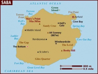
 Map - click for larger view | |
 Flag | |
| Capital: | The Bottom |
|---|---|
| Language: | Dutch, English |
| Currency: | US Dollar (USD) |
| Timezone: | UTC-4 |
| More notes about the country | |
| | |
| Content - news items, etc. | |
Overview
Cruising the region
See Leeward Islands and Netherlands Antilles
Climate & Weather
Submit the climate & general weather details here.
Sources of weather forecasting here.
Charts
Submit details of the charts required for safe navigation of the area.
Any navigation notes here.
Local Radio Nets
Also see World Cruiser's Nets
Arrival/Departure procedures
Arrival
Details?
Departure
Details?
Customs and Immigration
Immigration
Details?
Customs
Details?
Fees and Charges
Restrictions
Ports & Popular Stops
Offshore Islands
Health
Submit any health warnings/information.
Security
Details?
Transportation
Transportation - mainland or to other countries, etc.
Cruiser's Friends
Contact details of "Cruiser's Friends" that can be contacted for local information or assistance.
Forum Discussions
List links to discussion threads on partnering forums. (see link for requirements)
External Links
References & Publications
Books, Guides, etc.
Personal Notes
Personal experiences?
|
|---|
|
Names: Haiqu |
| |
|---|
| | HOMEPAGE | Wiki Contents | Caribbean | Leeward Islands | Netherlands Antilles | Saba | |