San Foca (Melendugno)
From CruisersWiki
m (Text replace - "{| class="infobox bordered" style="width: 33em; text-align: left; font-size: 85%;" " to "{| class="infobox bordered" style="width: 28em; text-align: left; font-size: 90%;"") |
m (Text replace - "#References & Publications|" to "#References|") |
||
| (30 intermediate revisions not shown) | |||
| Line 1: | Line 1: | ||
| - | + | {{IsPartOf|Mediterranean|Adriatic Sea|Italy|Adriatic Coast of Italy}} | |
| - | {| | + | {{TOC block}} |
| - | | | + | |
| - | + | ||
| - | + | ||
| - | + | ||
| - | + | ||
| - | + | ||
| - | + | ||
| - | + | ||
| - | + | ||
| - | + | ||
| - | + | ||
| - | + | ||
| - | The small harbour of San Foca lies on the Adriatic coast of [[Italy]], 12 miles N of the port of [[Otranto]] and six kilometers NE of the town of Melendugno. | + | {{Infobox |
| + | | lat= 40.30333|lon=18.40817 | ||
| + | | name= San Foca di Melendugno | ||
| + | | portofentry= | ||
| + | | zoom= 15 | ||
| + | | chartlet = y | ||
| + | | image= SanFoca.jpg | ||
| + | | imagetext= San Foca harbour from E | ||
| + | | summary= The small harbour of '''San Foca''' lies on the Adriatic coast of [[Italy]], 12 miles N of the port of [[Otranto]] and six kilometers NE of the town of Melendugno. Until recently a tiny, small craft harbour with depths of little more than 1.0 - 1.5 metres, a long, curved northern breakwater has been constructed, creating a new outer basin suitable for yachts of up to 25 metres. Shelter here is good in all winds except strong SE, when [[Otranto]] provides better shelter. | ||
| + | | notes= | ||
| + | | news= | ||
| + | }} | ||
| - | |||
==Charts== | ==Charts== | ||
| - | + | ; British Admiralty | |
| - | + | : 187 | |
| + | : 188 | ||
| + | ; Italian | ||
| + | : 920 | ||
| + | : 28 | ||
| + | : 189 | ||
| - | == | + | ==Weather== |
| - | '' | + | During the summer months, the prevailing winds in the Adriatic are light to moderate coastal sea breezes. In spring and autumn, northerly winds are more frequent and can quickly rise to near gale force, especially in the northern Adriatic, where the much-feared “bora” is caused by high pressure over the mountains to the NE coupled with low pressure over southern Italy. Fortunately, the fiercest “bora” is normally to be expected in the winter months. Thunderstorms are occasionally experienced in spring and especially autumn and can be accompanied by violent winds of gale force and above. Luckily they are rarely long-lasting. In the southern Adriatic, the “Scirocco”, a S/SE wind blowing up from North Africa which can last for several days, is more common. Unlike the “bora”, which can arrive without warning, a “Scirocco” tends to build in strength over 24-48 hours, sometimes reaching gale force (especially in winter). |
| + | |||
| + | Sources for weather information: | ||
| + | * There is a continuous (computerized voice) weather forecast on VHF 68 - first in Italian and then followed with an English translation | ||
| + | * The same forecast is given in Italian and English on VHF coastal stations following a notification on channel 16 | ||
| + | * Navtex weather forecasts covering the Adriatic are broadcast from stations at Roma, Trieste, Kerkyra ([[Greece]]) and Split ([[Croatia]]) | ||
| + | {{hold horizontal}} | ||
| + | |||
| + | ==Passages== | ||
| + | ''See [[Adriatic_Sea#Passages|Adriatic]]''. | ||
| + | |||
| + | ==Communication== | ||
| + | {{Green|Add here VHF channel for the coastguard, harbor masters. etc.}} | ||
* | * | ||
| + | * | ||
| - | + | ''Also see [[World MM Nets|World Cruiser's Nets]]''. | |
| - | + | ||
| - | + | ==Navigation== | |
| - | + | In the approach from both N and S, keep at least 500 metres off the shore to avoid the shoals 300 metres N and 500m metres S of the harbour. The long curved breakwater is conspicuous once close in. Entrance is from SE between this and the smaller breakwater of the inner basin. Depths in the entrance are 5.0 - 6.0 metres. | |
| - | + | ||
| - | + | ||
| - | + | ||
| - | == | + | |
| - | In the approach from both N and S, keep at least 500 metres off the shore to avoid the shoals 300 metres N and 500m metres S of the harbour. | + | |
| - | == | + | ==Berthing== |
| - | + | {{poi | lat= 40.30244| lon=18.40554 | |
| + | | type= harbour | ||
| + | | name= Porto Turistico di San Foca | ||
| + | | altname= | ||
| + | | url = http://www.portodisanfoca.it/en/ | ||
| + | | zoom= 16 | ||
| + | | portofentry= | ||
| + | | image= | ||
| + | | imagetext= | ||
| + | | text= Inside the new breakwater and protected from S by a short inner breakwater are three pontoons in depths of 4.0 - 5.0 metres operated by the '''Porto Turistico di San Foca'''. Along the quay of the outer, curved breakwater are additional berths in similar depths, providing a total of 150 berths of which 20 are reserved for yachts in transit. Maximum length 25 metres. Laid moorings at all berths. Fuel station. Water and electricity. Toilets and showers. Slipway. | ||
| + | : {{email|[email protected]}}; Tel: {{phone|39|0832|881 183}}; Fax: {{fax|39|0832|840 831}}; VHF channels 12 & 16 | ||
| + | : Address: Lungomare Matteotti 6, 72026 San Foca, Lecce, Italy | ||
| + | }} | ||
| - | == | + | ===Marinas & Yacht Clubs=== |
None. | None. | ||
| - | |||
| - | |||
| - | |||
==Anchorages== | ==Anchorages== | ||
None. | None. | ||
| - | == | + | ==Amenities== |
| - | + | {{tlist | |
| - | + | ||
| - | + | ||
| - | + | |header|Facilities | |
| - | + | ||
| - | + | |Water| Water on the pontoons | |
| - | + | |Electricity| Electricity on the pontoons | |
| + | |Toilets| In [[#Porto Turistico di San Foca|Porto Turistico di San Foca]] | ||
| + | |Showers| In [[#Porto Turistico di San Foca|Porto Turistico di San Foca]] | ||
| + | |Laundry| N/A (Not Available) | ||
| + | |Garbage| Bins at the harbour | ||
| - | + | |header|Supplies | |
| - | + | |Fuel| Fuel station on the quay (0700 - 2000)) | |
| - | + | |Bottled gas| {{MagentaText|?}} | |
| + | |Chandlers| None | ||
| - | + | |header|Services | |
| - | + | |Repairs| Slipway. Mobile crane (5 T). Some engine, electrical and electronic repairs. Fiberglass hull repairs. Divers. | |
| - | + | |Internet| {{MagentaText|?}} | |
| + | |Mobile connectivity| {{MagentaText|?}} | ||
| + | |Vehicle rentals| {{MagentaText|?}} | ||
| + | }} | ||
| - | == | + | ==Provisioning== |
| - | + | Provisions shops in the village. | |
| - | + | ||
| - | + | ||
| - | + | ||
| - | + | ||
| - | + | ||
| - | + | ||
| - | + | ||
| - | + | ||
| - | + | ||
| - | + | ||
| - | == | + | ==Eating out== |
| - | + | Restaurants and pizzerias in the village. | |
| - | + | ==Transportation== | |
| - | * Buses to Rome via Lecce and Brindisi. | + | * Buses to Rome via Lecce and [[Brindisi]]. |
| - | * Local and international flights from Brindisi airport. | + | * Local and international flights from [[Brindisi]] airport. |
* Trains to most destinations from Lecce. | * Trains to most destinations from Lecce. | ||
| - | == | + | ==Tourism== |
| - | + | Tourist interest is limited, although there is a 15th-century defensive tower on the coast and behind the village of San Foca a Roman settlement has been excavated. | |
| - | + | ||
| - | == | + | ==Friends== |
Contact details of "Cruiser's Friends" that can be contacted for local information or assistance. | Contact details of "Cruiser's Friends" that can be contacted for local information or assistance. | ||
* | * | ||
| - | == | + | ==Forums== |
| - | List links to discussion threads on [[Cruising Forums|partnering forums]]. (see link for requirements) | + | List links to discussion threads on [[Cruising Forums|partnering forums]]. (''see link for requirements'') |
* | * | ||
| + | |||
| + | ==Links== | ||
| + | * {{wikipedia|Melendugno|Melendugno}} | ||
* | * | ||
| - | == | + | ==References== |
| - | + | ''See [[Italy#References|Italy]]''. | |
| - | + | ||
| - | + | ||
| - | + | {{Comments}} | |
| - | + | ||
| - | + | ||
* | * | ||
| - | + | {{Verified by}} | |
| - | + | ||
* Data compiled from web research (please update if possible)--[[User:Atheneoflymington|Athene of Lymington]] 15:22, 23 December 2010 (UTC) | * Data compiled from web research (please update if possible)--[[User:Atheneoflymington|Athene of Lymington]] 15:22, 23 December 2010 (UTC) | ||
* | * | ||
| - | + | {{Green|If you provide a lot of info and this page is almost complete, change <nowiki>{{Page outline}} to {{Page useable}}</nowiki>.}} | |
| - | + | ||
| - | + | ||
| - | {{ | + | {{Page outline}} |
| - | + | {{Contributors|[[User:Atheneoflymington|Athene of Lymington]]}} | |
| - | {| | + | |
| - | + | ||
| - | + | ||
| - | + | ||
| - | + | ||
| - | + | ||
| - | + | ||
| - | + | ||
| - | + | ||
| - | + | ||
| - | + | ||
| - | + | ||
| - | + | ||
[[Category:Ports - Italy]] | [[Category:Ports - Italy]] | ||
| - | |||
| - | |||
| - | |||
Latest revision as of 07:59, 21 August 2018
| San Foca di Melendugno
| |
| |
 San Foca harbour from E |
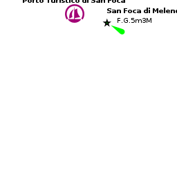
The small harbour of San Foca lies on the Adriatic coast of Italy, 12 miles N of the port of Otranto and six kilometers NE of the town of Melendugno. Until recently a tiny, small craft harbour with depths of little more than 1.0 - 1.5 metres, a long, curved northern breakwater has been constructed, creating a new outer basin suitable for yachts of up to 25 metres. Shelter here is good in all winds except strong SE, when Otranto provides better shelter.
Charts
- British Admiralty
- 187
- 188
- Italian
- 920
- 28
- 189
Weather
During the summer months, the prevailing winds in the Adriatic are light to moderate coastal sea breezes. In spring and autumn, northerly winds are more frequent and can quickly rise to near gale force, especially in the northern Adriatic, where the much-feared “bora” is caused by high pressure over the mountains to the NE coupled with low pressure over southern Italy. Fortunately, the fiercest “bora” is normally to be expected in the winter months. Thunderstorms are occasionally experienced in spring and especially autumn and can be accompanied by violent winds of gale force and above. Luckily they are rarely long-lasting. In the southern Adriatic, the “Scirocco”, a S/SE wind blowing up from North Africa which can last for several days, is more common. Unlike the “bora”, which can arrive without warning, a “Scirocco” tends to build in strength over 24-48 hours, sometimes reaching gale force (especially in winter).
Sources for weather information:
- There is a continuous (computerized voice) weather forecast on VHF 68 - first in Italian and then followed with an English translation
- The same forecast is given in Italian and English on VHF coastal stations following a notification on channel 16
- Navtex weather forecasts covering the Adriatic are broadcast from stations at Roma, Trieste, Kerkyra (Greece) and Split (Croatia)
Passages
See Adriatic.
Communication
Add here VHF channel for the coastguard, harbor masters. etc.
Also see World Cruiser's Nets.
In the approach from both N and S, keep at least 500 metres off the shore to avoid the shoals 300 metres N and 500m metres S of the harbour. The long curved breakwater is conspicuous once close in. Entrance is from SE between this and the smaller breakwater of the inner basin. Depths in the entrance are 5.0 - 6.0 metres.
Berthing
Porto Turistico di San Foca
Inside the new breakwater and protected from S by a short inner breakwater are three pontoons in depths of 4.0 - 5.0 metres operated by the Porto Turistico di San Foca. Along the quay of the outer, curved breakwater are additional berths in similar depths, providing a total of 150 berths of which 20 are reserved for yachts in transit. Maximum length 25 metres. Laid moorings at all berths. Fuel station. Water and electricity. Toilets and showers. Slipway.
- [email protected]; Tel: +39 (0832) 881 183; Fax: +39 (0832) 840 831; VHF channels 12 & 16
- Address: Lungomare Matteotti 6, 72026 San Foca, Lecce, Italy
Marinas & Yacht Clubs
None.
Anchorages
None.
Amenities
| Facilities | |
|---|---|
| Water | Water on the pontoons |
| Electricity | Electricity on the pontoons |
| Toilets | In Porto Turistico di San Foca |
| Showers | In Porto Turistico di San Foca |
| Laundry | N/A (Not Available) |
| Garbage | Bins at the harbour |
| Supplies | |
| Fuel | Fuel station on the quay (0700 - 2000)) |
| Bottled gas | ? |
| Chandlers | None |
| Services | |
| Repairs | Slipway. Mobile crane (5 T). Some engine, electrical and electronic repairs. Fiberglass hull repairs. Divers. |
| Internet | ? |
| Mobile connectivity | ? |
| Vehicle rentals | ? |
Provisioning
Provisions shops in the village.
Eating out
Restaurants and pizzerias in the village.
Transportation
- Buses to Rome via Lecce and Brindisi.
- Local and international flights from Brindisi airport.
- Trains to most destinations from Lecce.
Tourism
Tourist interest is limited, although there is a 15th-century defensive tower on the coast and behind the village of San Foca a Roman settlement has been excavated.
Friends
Contact details of "Cruiser's Friends" that can be contacted for local information or assistance.
Forums
List links to discussion threads on partnering forums. (see link for requirements)
Links
- Melendugno at the Wikipedia
References
See Italy.
Comments
We welcome users' contributions to the Wiki. Please click on Comments to view other users' comments, add your own personal experiences or recommend any changes to this page following your visit.
Verified by
Date of member's last visit to San Foca (Melendugno) and this page's details validated:
- Data compiled from web research (please update if possible)--Athene of Lymington 15:22, 23 December 2010 (UTC)
If you provide a lot of info and this page is almost complete, change {{Page outline}} to {{Page useable}}.
| This page has an outline in place but needs completing. Please contribute if you can to help it grow further. Click on Comments to suggest further content or alternatively, if you feel confident to edit this page, click on the edit tab at the top and enter your changes directly. |
| |
|---|
|
Names: Athene of Lymington |