Skopelos
From CruisersWiki
Istioploos (Talk | contribs) |
Istioploos (Talk | contribs) |
||
| Line 3: | Line 3: | ||
===Background=== | ===Background=== | ||
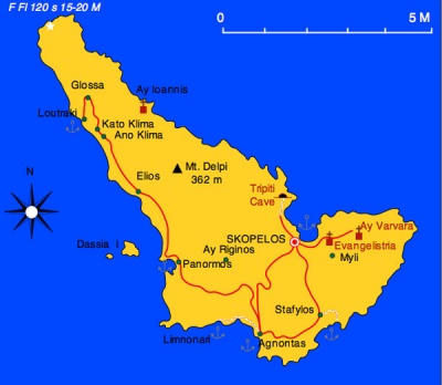
| - | [http://en.wikipedia.org/wiki/ | + | [http://en.wikipedia.org/wiki/Skopelos Skopelos] (Σκόπελος) is a very green mountainous island with an area of 96 km<sup>2</sup> and about 5,500 inhabitants. It highest peak is Delphi at 366 m (1200 ft.). There are many natural springs and about a fifth of the island is cultivated with olive groves, plum trees, almond, and orange trees. Its capital Skopelos or Chora, is also its main harbor and it is located on the NE of the island. More than half of the island's inhabitants live there. |
In the antiquity the island was known as Peparethos. According to the tradition, it was colonized on the 16 century BC by the king of Crete, [http://en.wikipedia.org/wiki/Staphylus Stafylos] who was the son of [http://www.maicar.com/GML/Ariadne.html Ariadne] and [http://www.maicar.com/GML/Dionysus2.html Dionysos]. His name means "he of grapes" and indeed Peparethos was well known in the ancient world for the quality of its wine. A cove on the SE corner of the island is still known today as Stafylos and a rich [http://en.wikipedia.org/wiki/Minoan_civilization Minoan] tomb was excavated there, in 1927. In historical times Skopelos was part of the [http://en.wikipedia.org/wiki/Delian_league Athenian League]. During the [http://en.wikipedia.org/wiki/Peloponesian_War Peloponnesian War] it fought on the side of Athens and after their defeat was briefly occupied by the [http://en.wikipedia.org/wiki/Ancient_sparta Spartans]. During this time Peparethos prospered and minded her own coins. The island worshipped in particular Dionysos and [http://www.maicar.com/GML/Demeter.html Demeter]. Later it fell to the [http://en.wikipedia.org/wiki/Macedonian_Empire Macedonians] and declined. In 146 BC it fell to the [http://en.wikipedia.org/wiki/Roman_Empire Romans] until 42 BC when it was granted to the Athenians, but in 196 AD it reclaimed by Rome. The present name Skopelos was first mentioned by [http://en.wikipedia.org/wiki/Ptolemy Ptolemy]. | In the antiquity the island was known as Peparethos. According to the tradition, it was colonized on the 16 century BC by the king of Crete, [http://en.wikipedia.org/wiki/Staphylus Stafylos] who was the son of [http://www.maicar.com/GML/Ariadne.html Ariadne] and [http://www.maicar.com/GML/Dionysus2.html Dionysos]. His name means "he of grapes" and indeed Peparethos was well known in the ancient world for the quality of its wine. A cove on the SE corner of the island is still known today as Stafylos and a rich [http://en.wikipedia.org/wiki/Minoan_civilization Minoan] tomb was excavated there, in 1927. In historical times Skopelos was part of the [http://en.wikipedia.org/wiki/Delian_league Athenian League]. During the [http://en.wikipedia.org/wiki/Peloponesian_War Peloponnesian War] it fought on the side of Athens and after their defeat was briefly occupied by the [http://en.wikipedia.org/wiki/Ancient_sparta Spartans]. During this time Peparethos prospered and minded her own coins. The island worshipped in particular Dionysos and [http://www.maicar.com/GML/Demeter.html Demeter]. Later it fell to the [http://en.wikipedia.org/wiki/Macedonian_Empire Macedonians] and declined. In 146 BC it fell to the [http://en.wikipedia.org/wiki/Roman_Empire Romans] until 42 BC when it was granted to the Athenians, but in 196 AD it reclaimed by Rome. The present name Skopelos was first mentioned by [http://en.wikipedia.org/wiki/Ptolemy Ptolemy]. | ||
| Line 34: | Line 34: | ||
===Ports and Popular Stops=== | ===Ports and Popular Stops=== | ||
====Skopelos Harbor==== | ====Skopelos Harbor==== | ||
| - | + | [[Image:Skopelos_h.jpg|350px|thumb|right|Chart of Skopelos Harbor<br/>''Click for larger view'']] | |
| - | | | + | Skopelos [39° 07' N 23° 43.5' E], the main harbor of the island is a large and noisy harbor. With a ''meltemi'' (NE) it can develop a very uncomfortable swell. Moor stern-to on the W side of the harbor but stay away from the ferries and hydrofoils. The bottom is mud and provides excellent holding. |
The town is rather attractive if you stay away from the waterfront. | The town is rather attractive if you stay away from the waterfront. | ||
<font color="red">Warning:</font> With strong NE winds (''meltemi'') the sea builds up and it may be dangerous to enter or leave the harbor. | <font color="red">Warning:</font> With strong NE winds (''meltemi'') the sea builds up and it may be dangerous to enter or leave the harbor. | ||
| - | |[[Image: | + | |
| + | <center><gallery widths="200px" perrow="2"> | ||
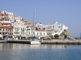
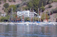
| + | Image:Skopelos_h3.jpg|View of the Harbor from the NE<br/>''Click for larger view'' | ||
| + | Image:Skopelos_h2.jpg|View of the Harbor from the S<br/>''Click for larger view'' | ||
| + | </gallery></center> | ||
| + | <center><gallery widths="200px" perrow="1"> | ||
| + | Image:Skopelos_h1.jpg|The Quay<br/>''Click for larger view'' | ||
| + | </gallery></center> | ||
| + | |||
| + | ====Glossa==== | ||
| + | [[Image:Skopelos_Glossa_h.jpg|350px|thumb|right|Chart of Glossa Harbor<br/>''Click for larger view'']] | ||
| + | Glossa (Γλώσσα) or Loutraki (Λουτράκι) [39° 09.5' N 23° 37' E] is an attractive but often crowded harbor. You can come stern-to the W quay, north of the ferry boat landing or anchor off if there is room. | ||
| + | |||
| + | On the E side of the harbor there is a loading dock that appears to be used exclusively by a flotilla. | ||
| + | |||
| + | The harbor is well protected from the ''meltemi''. The bottom is sand and weed and provides good holding. | ||
| + | |||
| + | The very attractive town of Glossa is about 1 hr. walk up the steep hill. | ||
| + | |||
| + | <center><gallery widths="200px" perrow="2"> | ||
| + | Image:Skopelos_Glossa.jpg|The Harbor of Glossa<br/>''Click for larger view'' | ||
| + | Image:Skopelos_Glos.jpg|The Floating Dock in Glossa<br/>''Click for larger view'' | ||
| + | </gallery></center> | ||
| + | |||
| + | ====Agnontas==== | ||
| + | {| | ||
| + | |valign="top"|Agnontas (Αγνώντας) is the third harbor in Skopelos. It is well protected from the meltemi and all N winds. Unfortunately there is a restaurant that continuously plays very loud music. Come along side-to. | ||
| + | |[[Image:Skopelos_Agnontas_h.jpg|350px|thumb|right|Chart of Agnontas<br/>''Click for larger view'']] | ||
|} | |} | ||
===Marinas & Yacht Clubs=== | ===Marinas & Yacht Clubs=== | ||
| - | + | None | |
===Anchorages=== | ===Anchorages=== | ||
| - | + | ====Panormos==== | |
===Offshore Islands=== | ===Offshore Islands=== | ||
| Line 80: | Line 107: | ||
===External Links=== | ===External Links=== | ||
| - | * [http://en.wikipedia.org/wiki/ | + | * [http://en.wikipedia.org/wiki/Skopelos Skopelos] (Wikipedia) |
* | * | ||
* | * | ||
Revision as of 15:54, 15 June 2008
Skopelos
Background
Skopelos (Σκόπελος) is a very green mountainous island with an area of 96 km2 and about 5,500 inhabitants. It highest peak is Delphi at 366 m (1200 ft.). There are many natural springs and about a fifth of the island is cultivated with olive groves, plum trees, almond, and orange trees. Its capital Skopelos or Chora, is also its main harbor and it is located on the NE of the island. More than half of the island's inhabitants live there.
In the antiquity the island was known as Peparethos. According to the tradition, it was colonized on the 16 century BC by the king of Crete, Stafylos who was the son of Ariadne and Dionysos. His name means "he of grapes" and indeed Peparethos was well known in the ancient world for the quality of its wine. A cove on the SE corner of the island is still known today as Stafylos and a rich Minoan tomb was excavated there, in 1927. In historical times Skopelos was part of the Athenian League. During the Peloponnesian War it fought on the side of Athens and after their defeat was briefly occupied by the Spartans. During this time Peparethos prospered and minded her own coins. The island worshipped in particular Dionysos and Demeter. Later it fell to the Macedonians and declined. In 146 BC it fell to the Romans until 42 BC when it was granted to the Athenians, but in 196 AD it reclaimed by Rome. The present name Skopelos was first mentioned by Ptolemy.
During the early Byzantine times, in the rain of Julian in the 4th century AD, the bishop of the island, Saint Riginos ( same as my last name) was martyred and became the patron saint of the island. At that time the island had a second prosperity. After the fall of Constantinople to the 4th Crusaders in 1204, Skopelos was occupied by the Venetians under the brothers Andrea and Jeremiah Gizzi who held it until 1276 when the Byzantines reclaimed the island. After Constantinople's fall to the Ottomans in 1453 the islanders petitioned to Venice to take over the Sporades islands. Venice held them until 1538 when the Ottoman admiral-pirate Barbarossa occupied them after heavily looting them.
During the Ottoman occupation, Skopelos prospered, developing a thriving shipping industry. At the Greek War of Independence of 1821, Skopelos with her significant fleet joined the rest of the islands. After the war, Skopelos, along with the rest of the Sporades, became part of the new Greek state. But the war had decimated her fleet and the island fell into hard times and was overrun by pirates, Admiral Miaoulis, the hero of the Greek revolution, subdued the pirates in 1828 but the island continued her decline which was accelerated by the advance of steam powered ships which made the traditionally built in Skopelos sailing ships obsolete. Today tourism, which has become the island's main industry, has brought it a new affluence.
Charts
BA 1062 Nísoi Voríoi Sporádhes
Imray-Tetra G25 Eastern Sporades and North Evvoia
NIMA 54348 Vorios Evoikos Kolpos and Notios Evoikos Kolpos
Greek 31 North Evoikos to Kavala Gulf
Greek 74 Corinth to Skopelos Island
Greek 331 Sporades to Ay. Efstratios
Radio Nets
Also see World Cruiser's Nets
- Coast Guard - VHF channel 12 and tel. Tel. +30 4240 22 180
- Olympia Radio - VHF channels 03 & 04
In general, during the summer months the meltemi is weaker in the Sporades region. Approaches to the island are straight forward, no dangers.
Specific dangers are mentioned, as needed, for each port or anchorage.
Ports and Popular Stops
Skopelos Harbor
Click for larger view
Skopelos [39° 07' N 23° 43.5' E], the main harbor of the island is a large and noisy harbor. With a meltemi (NE) it can develop a very uncomfortable swell. Moor stern-to on the W side of the harbor but stay away from the ferries and hydrofoils. The bottom is mud and provides excellent holding.
The town is rather attractive if you stay away from the waterfront.
Warning: With strong NE winds (meltemi) the sea builds up and it may be dangerous to enter or leave the harbor.
Glossa
Click for larger view
Glossa (Γλώσσα) or Loutraki (Λουτράκι) [39° 09.5' N 23° 37' E] is an attractive but often crowded harbor. You can come stern-to the W quay, north of the ferry boat landing or anchor off if there is room.
On the E side of the harbor there is a loading dock that appears to be used exclusively by a flotilla.
The harbor is well protected from the meltemi. The bottom is sand and weed and provides good holding.
The very attractive town of Glossa is about 1 hr. walk up the steep hill.
Agnontas
| Agnontas (Αγνώντας) is the third harbor in Skopelos. It is well protected from the meltemi and all N winds. Unfortunately there is a restaurant that continuously plays very loud music. Come along side-to. | File:Skopelos Agnontas h.jpg Chart of Agnontas Click for larger view |
Marinas & Yacht Clubs
None
Anchorages
Panormos
Offshore Islands
List Islands
Routes/Passages To/From
Popular passages/routes, timing, etc.
Tourism & things to do ashore
Also see each Port/Stop
Marine Stores & Facilities
See each Port/Stop
References & Publications
Publications, Guides, etc.
Cruiser's Friends
Contact details of "Cruiser's Friends" that can be contacted for local information or assistance.
Forum Discussions
List links to discussion threads on the Cruiser Log Forum
External Links
- Skopelos (Wikipedia)
Personal Notes
Personal experiences?
.


