Skyros
From CruisersWiki
Istioploos (Talk | contribs) (→Skyros: Format) |
Istioploos (Talk | contribs) m (→Last Visited & Details Checked (and updated here): Navigation Bar) |
||
| Line 233: | Line 233: | ||
| - | < | + | {|id="mp-right" width="100%" cellpadding="2" cellspacing="1" style="vertical-align:top; background:#f5faff; border:1px solid #a3b0bf;" |
| + | ! <h2 id="mp-itn-h2" style="margin:0; background:#cedff2; font-size:120%; font-weight:bold; border:1px solid #a3b0bf; text-align:left; color:#000; padding:0.2em 0.4em;">Cruising Wiki Navigation</h2> | ||
| + | |- | ||
| + | |style="color:#000;"| | [[Cruising_and_Sailing_Wiki_by_CruiserLog|HOMEPAGE]] | [[Cruising|Wiki Contents]] | [[Med|Mediterranean]] | [[Greece]] | [[Skyros]] | | ||
| + | |} | ||
. | . | ||
Revision as of 18:53, 21 November 2008
Skyros
Background
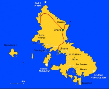
Skyros (Σκύρος) or Skiros is the most isolated island of the Sporades group, and as a result not too many yachts visit it. Skyros has about 4,000 inhabitants and an area of 210 km2. The tallest peak is Mt. Kokhilas (792 m).
Skyros has a rather long history. In Greek Mythology its king, Lycomedes, offered hospitality to Theseus when he was an old man, but he became very jealous of his fame and murdered him. The same Lycomedes hid Achilles as a favor to Thetis, Achilles' mother, so that he could avoid going to the Trojan War. In more historical times, the island was conquered by the Athenians in 470 BC. In 404 BC it was taken over by the Spartans, and in 322 BC by the Macedonians who were followed by the Romans.
Skyros then became part of the Byzantine Empire until the 15th century when it was taken over by the Venetians. They held it until 1538 when the Ottoman Turks took it and held it until the end of the http://en.wikipedia.org/wiki/Greek_War_of_Independence Greek War of Independence] in 1821 when it became part of Greece.
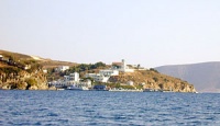
Today Skyros is renowned for its folk art and its Carnival. The largest town is Chora, or Skyros, which is built around the Venetian castle. It is about 10 km from the Linaria harbor.
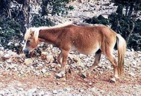
Native to Skyros is a rare species of small pony called Pikermic.
Charts
BA 1062 Nisoi Voríoi Sporades
BA 2048 Skyros island
Imray-Tetra G26 Nisos Evvoia
Imray-Tetra G25 Northern Sporades and North Nisos Evvoia
NIMA 54350 Nisoi Vorioi Sporadhes
54352 Plans in theAegean Sea: Nisos Skyros
Greek 33 Cape Sounion to Lesvos I.
Radio Nets
Also see World Cruiser's Nets
- Coast Guard - VHF channel 12 & Tel. +30 2220 91 475
- Olympia Radio - VHF channel 63, no signal in Ayios Phokas and in Skantzoura
- GSM/GPRS - No signal in Ayios Phokas and in Skantzoura
Approaches to Skyros are easy but Skyros is a very windy island its N side of is exposed to very rough seas. All of the anchorages are on the S side with the exception of the "marina." The only harbor in the island is Linaria.
Ports and Popular Stops
Linaria Harbor
| Linaria (Λινάρια) is a small harbor [38°52' N 24°32.5' E] and it offers good protection from the meltemi as well as from the S winds. Anchoring is very difficult because of the many laid moorings and bad holding. Most yachts moor alongside the W quay but avoid the ferryboat area. There is only room for about 3 yachts. Rafting is quite common. If there is no room you van anchor off-shore at the near by Linaria Cove.
The harbor is very pleasant with a few restaurants and stores. There is a water outlet at the quay, with water available, sometimes, and a near by fuel station. The town of Chora is about 10 km away. There is a bus twice a day. For a taxi call +30 2220 91 666. Last Visited & Details Checked (and updated here)Date of member's visit to this Port/Stop & this page's details validated:
File:Skyros Linaria1.jpg The harbor of Linaria Click for larger view | File:Skyros Linaria h.jpg Chart of Linaria harbor Click for larger view |
Marinas & Yacht Clubs
Anchorages
Linaria Cove
| Linaria Cove [38° 50.6' N 24° 28.6' E] is just N of Linaria Harbor. It is open to the S winds. It well protected from the meltemi despite the strong gusts. The bottom is mostly mud and provides good holding.
Caution: On the NE over the hill there is an electric power plant. It is refueled by some underwater pipes located between 2 small buoys. Stay away form the E side of the cove. The cove is a very pleasant and much more quieter than the harbor despite the proximity of the power plant. You can easily go ashore and leave the dingy at the small pier at the E side. Linaria is a 10 minute walk. Alternatively you can take the dingy to the harbor. On the NE corner of the cove there is a restaurant that has a good reputation with the locals. Last Visited & Details Checked (and updated here)Date of member's visit to this Port/Stop & this page's details validated:
| File:Skyros LinariaCove m.jpg Chart of Linaria Cove Click for larger view |
Ayios Phokas
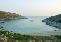
| Ayios Phokas or Ayios Fokas (Άγιος Φωκάς) [38° 52.4' N 24° 28.6' E] is a gorgeous anchorage with very bright green pines all around, almost up to the water line. Anchor at 4m, very good holding on sand .
There is a restaurant ashore which serves good food. Last Visited & Details Checked (and updated here)Date of member's visit to this Port/Stop & this page's details validated:
| File:Skyros AyFokas m.jpg Chart of Ayios Phokas Click for larger view |
Stin Angali
Stin Angali (Στήν Αγκάλη - in the embrace) is a lovely setting and a safe anchorage but liable to have some swell. There is a restaurant ashore.
Port Achladi
This is supposed to be a very good anchorage. I have only seen it from a distance and it looks very attractive (--Istioploos 08:42, 4 May 2008 (MDT)).
Tris Bookes
Tris Bookes (Τρείς Μπούκες) or Trebuki is a very large natural harbor and has been used by the British and Greek navies as an anchorage. The name means three mouths and is descriptive of this large bay protected by two islands that give it three openings. However, it less suitable for yachts because of fierce gusts and swell. Also a Greek Naval base is under construction and could restrict access.
Renes Bay
This is cove on the SE corner of the island.
Offshore Islands
Sarakino
There is wonderful secluded anchorage at the S side of Sarakino Island (Σαράκινο) [38° 45' N 24° 36.9' E]. It provides good shelter from the meltemi but it is exposed to the S. The bottom is sand and weeds and provides good holding. Anchor at 4-6 m and take a shore line to a rock. Watch out for the many sea urchins.
Last Visited & Details Checked (and updated here)Date of member's visit to this Port/Stop & this page's details validated:
| File:Skyros Sarakino h.jpg Chart of Sarakino Click for larger view |
Skyropoula
The S side of Skyropoula (Σκυροπούλα) is nice place for a temporary anchorage. There is very good spearfishing.
Last Visited & Details Checked (and updated here)
Date of member's visit to this Port/Stop & this page's details validated:
- 1991 --Istioploos 11:10, 6 June 2008 (MDT)
Skantzoura
| Skantzoura (Σκάντζουρα) is a small uninhabited island. The only structure on it is an old hermitage, now abandoned. It is a very pleasant if isolated place.
The island is within the Marine Park which was established a few years ago to protect marine life and particularly the highly endangered Mediterranean seal. All fishing is strictly forbidden. Yachts can stay for only one night. The organization for the preservation of the Mediterranean Seal, Monachus Monachus or as it is locally known, MOm, patrols the Marine Park and enforces its regulations. There are three anchorages at Skantzoura bay, on the W side of the island that afford some protection from the meltemi. All are exposed to the W. The bottom is sand and weed and provides reasonable holding. For an overnight, it is best to get near the shore and take a shore line to a rock, in addition to the anchor. Caution: There numerous unmarked low lying islets and reefs at the entrance to Skantzoura bay. Entry to and exit from the bay after dark is dangerous. Last Visited & Details Checked (and updated here)Date of member's visit to this Port/Stop & this page's details validated:
| File:Skyros Skantzoura m.jpg Chart of Skantzoura Click for larger view |
Routes/Passages To/From
Popular passages/routes, timing, etc.
Tourism & things to do ashore
Chora
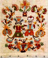
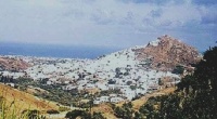
This is one of the most picturesque towns in the Aegean. It is built on a hill which is crowned by a Venetian Castle. The traditional houses are well kept and always freshly white washed. Skyros is one the few places left in Greece where traditional folk crafts are thriving. Not only architecture but woodcarving, ceramics and embroidery are practiced with great flair.
Good samples of these crafts can be seen at the well known Faltaitz Museum of Folkloric art. It is small but very eclectic. It was founded by Manos Faltaitz who is still overseeing its function. He is Greek, and a native of Skyros. The original family name was Faltsis, but it was corrupted to Faltaitz in Odessa where his father did business. The museum is housed in the family house and a number of rooms have been re-created as there were last century. The exhibit consists of Skyrian furniture, chests, embroidery, traditional costumes, Carnival costumes with their large bells and masks, books, etc.
Next to the Faltaitz Museum is the Archaeological Museum. It is small and it has an interesting collection of Prehistoric, Mycenaean and Geometric finds from the Magazia excavation.
The narrow windy streets in Chora are full of surprises. Now a lovely courtyard, now a store with a man carving a wooden cradle, now a cozy restaurant.
Tris Bookes
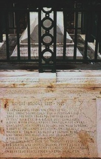
Here, in an isolated spot among the olive trees is the grave of the British Poet Rupert Brooke. The grave is considered British soil and is maintained by a society in England. He was already a well known young poet when he died in 1915, at sea, on his way to the Gallipoli battle. He was 28 years old. They buried him here, some distance from the sea, while the boat lay at anchor in the bay. It is still very moving.
Fuel, Water, & Electricity
- Fuel: In Linaria at the W corner of the quay there is a fuel station. Depending on the location of the yacht, the hose may reach or the owner, if he fills like it, will deliver fuel to a yacht with his mini tank. Otherwise you can carry jerry cans the short distance
- Water: In Linaria there is water outlet next to the quay where a hose can be used
- Electricity: N/A
Laundry
There is at least one laundry in Chora.
Grocery Stores
There are several small stores in Linaria and many stores in Chora. On the road to Chora there is a large supermarket.
Eateries
- The restaurants in Linaria rather indifferent
- There is a large variety of restaurants in Chora. The Ο Παππούς καί εγώ... (My Grandfather and I ...) serves an excellent variety of local dishes.
- The restaurant in Ayios Phokas serves good food
Motorbike & Car Rentals
Only in Chora.
Marine Stores & Facilities
Only fishing supplies.
Repairs
N/A.
Transportation
There are flights to/from Athens.
References & Publications
See Greece.
Cruiser's Friends
Contact details of "Cruiser's Friends" that can be contacted for local information or assistance.
Forum Discussions
List links to discussion threads on the Cruiser Log Forum
External Links
- Skyros (Wikipedia)
Personal Notes
Personal experiences?
Last Visited & Details Checked (and updated here)
See individual ports in this page.
| |
|---|
| | HOMEPAGE | Wiki Contents | Mediterranean | Greece | Skyros | |
.
