Suwarrow
From CruisersWiki
Lighthouse (Talk | contribs) m (Text replace - "List links to discussion threads on the Cruiser Log Forum" to "List links to discussion threads on partnering forums. (see link for requirements)") |
Lighthouse (Talk | contribs) m (Text replace - "Wiki Contents" to "Wiki Contents") |
||
| Line 96: | Line 96: | ||
! <h2 id="mp-itn-h2" style="margin:0; background:#cedff2; font-size:120%; font-weight:bold; border:1px solid #a3b0bf; text-align:left; color:#000; padding:0.2em 0.4em;">Cruising Wiki Navigation</h2> | ! <h2 id="mp-itn-h2" style="margin:0; background:#cedff2; font-size:120%; font-weight:bold; border:1px solid #a3b0bf; text-align:left; color:#000; padding:0.2em 0.4em;">Cruising Wiki Navigation</h2> | ||
|- | |- | ||
| - | |style="color:#000;"| | [[World Cruising and Sailing Wiki|HOMEPAGE]] | [[Cruising|Wiki Contents]] | [[South Pacific]] | [[Cook Islands]] | [[Suwarrow]] | | + | |style="color:#000;"| | [[World Cruising and Sailing Wiki|HOMEPAGE]] | [[World Cruising Guides|Wiki Contents]] | [[South Pacific]] | [[Cook Islands]] | [[Suwarrow]] | |
|} | |} | ||
. | . | ||
Revision as of 14:51, 12 September 2010
Suwarrow
Background
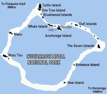
Suwarrow (also called Suvorov, Suvarou or Suvarov) is a low coral atoll in the Cook Islands in the Pacific Ocean. It is about 1,300 km south of the equator and 825 km northwest of Rarotonga, from which it is administered.
A caretaker resides on Anchorage Island. The only way to visit the island is with a private yacht or by chartered expedition from Rarotonga.
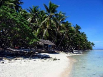
Most of the small islets have only herbs and shrubs, with Pemphis acidula and beach heliotrope (Tournefortia argentea) growing in abundance. The larger islands have a dense interior vegetation of Cordia subcordata (tou); indeed, the westernmost island, Motu Tou is named after this woodland, its name literally means "high island".
Charts
Submit the chart details that are required for safe navigation.
Radio Nets
Also see Cruiser's Nets
Weather
Local weather conditions?
Sources for Weather forecasts:
Obtain prior permission to visit Suwarrow.
There is only one passage into the 60-mile long lagoon and this passage into the lagoon is fairly narrow - approach during daylight hours only. The approach is a dog-leg to the right with coral heads on either side. The approach is further complicated by a 2-3 knot cross-current, port to starboard. Once through the dog-leg to the right, it is a natural entrance to one of the most magnificent blue water lagoons in the world.
On arrival in Suwarrow the crew must dinghy into the beach and report to the local caretaker. As this is a National Park, it is required that the local caretaker accompany any visitor to any of the "islands" around the lagoon.
Anchorages
List details of all safe anchorages in the area.
Tourism & things to do ashore
List places of interest, tours, etc.
Fuel, Water, & Electricity
Laundry
Internet/WiFi
Available?
Garbage Disposal
?
Routes/Passages To/From
Popular passages/routes, timing, etc.
References & Publications
Publications, Guides, etc.
Cruiser's Friends
Contact details of "Cruiser's Friends" that can be contacted for local information or assistance.
Forum Discussions
List links to discussion threads on partnering forums. (see link for requirements)
External Links
Links to relevant websites.
Personal Notes
Personal experiences?
Last Visited & Details Checked (and updated here)
Date of member's visit to this Port/Stop & this page's details validated:
| |
|---|
| | HOMEPAGE | Wiki Contents | South Pacific | Cook Islands | Suwarrow | |
.

