Tavira
From CruisersWiki
Tavira, Portugal
| | |
| | 36°06.39′N, 07°36.5′W |
|---|---|
| | [ Photo gallery] |
| | [ Local chartlet] |
The town of Tavira lies some 15 miles east of Faro in the heart of the Ria Formosa nature reserve. Its origins lie back in the Bronze Age, and it subsequently became an important Phoenician settlement. During the Roman era, the area declined in importance until the arrival of the Moors in the 8th century, who revived the fortunes of town, constructing the castle, palaces and the impressive seven-arched bridge (known erroneously as the Roman bridge) across the River Gilão. Moorish rule in Tavira ended in 1242, when the town was taken back by Christian forces under Dom Paio Peres Correia. The port expanded until by the 17th century it was one of the most important in the Algarve, but was virtually destroyed in the 1755 earthquake and tsunami. Most of the buildings and churches of the town today date from the 18th century, albeit the church of Santa Maria do Castelo, built on the site of a Moorish mosque, dates from the 13th century. The church contains the tomb of the town’s liberator Dom Paio Peres Correia and its clock tower was reconstructed from the original Muslim minaret. As a result of silting of the River Gilão, Tavira has lost its importance as a harbour although its attractiveness as a town and superb beaches within easy reach have established it firmly on the Algarve tourism map. Cruising visitors to Tavira anchor in the channel behind the long sandy Ilha de Tavira; the channel upriver to the town is only navigable by inflatable.
Charts
Submit the chart details that are required for safe navigation.
- Chart Source
- Chart No
- Chart No
Radio Nets
Also see World Cruiser's Nets
Local Weather
Local weather conditions?
Sources for Weather forecasts:
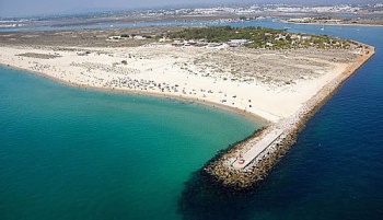
Like the entrance to Faro 15 miles to the west, the entrance to Tavira (36°06.39′N, 07°36.5′W) is a narrow channel between two moles separating the long, low sandy island of Ilha de Tavira extending six miles to the SW and the similar Ilha de Cabanas stretching four miles to the NE. The recommended approach is on a heading of 275° until close to the end of the western breakwater, then turning onto 325° to pass through the entrance. The deeper water is to the port side of the channel. After entering, follow the channel round to port and anchor where convenient.
Check-in facilities (for Customs and Immigration)
Tavira is an anchorage only. Anchor as close to the edge of the channel as the tides allow (fishing boats charge in and out of here at all hours). Ideally, it is best to lay both bow and stern anchors to hold yourself steady - tidal currents can run at 3-4 knots here. You are also less likely to be deposited on the mud in the event of an unexpected change in wind direction.
Offshore Islands and Groups
Ilha de Tavira and Ilha de Cabanas lie either side of the entrance channel.
Marinas & Yacht Clubs
None.
Yacht Repairs and Services
Marine Stores
Submit addresses and contact details of marine related businesses that are of interest to cruisers.
Repairs/Yards
None.
Fuel, Water, & Electricity
None. Bring your own.
Tourism and Things to do Ashore
Tourism
The town of Tavira is about a mile inland and is well worth the trip. Leave your dinghy at the jetty and walk through the salt pans along the tree-lined and canalized River Gilão. Tavira is a very pleasant spot, with beautiful gardens in the ruins of the old Moorish castle and an old Moorish bridge (wrongly known as ‘Roman’ until recent archaeological evidence proved its true antiquity). One can also take the dinghy in good weather to the islands of Tavira or Cabanas and their superb beaches.
Grocery & Supply Stores
Eateries
Internet/WiFi
No.
Laundry
None.
Motorbike & Car Rentals
Garbage Disposal
None. Take it with you.
Transportation
Transportation (local and/or international)
Routes/Passages To/From
Popular passages/routes, timing, etc.
Cruiser's Friends
Contact details of "Cruiser's Friends" that can be contacted for local information or assistance.
Forum Discussions
List links to discussion threads on the Cruiser Log Forum
External Links
Links to relevant websites.
References & Publications
Publications, Guides, etc.
Last Visited & Details Checked (and updated here)
Date of member's visit to this Port/Stop & this page's details validated:
- May 2001 --Athene of Lymington 20:11, 22 March 2010 (UTC)
Personal Notes
Personal experiences?
- Do not buoy your anchor here, as pilot books sometimes advise. The tidal currents are so strong you risk wrapping it round your keel as the tide turns and lifting your own anchor; believe me, it happens! - s/y Athene of Lymington.
| |
|---|
| | HOMEPAGE | Wiki Contents | Place Page Links Here | edit/remove | |
.


