Vela Luka
From CruisersWiki
| Vela Luka Port of Entry
| |
| | |
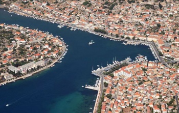
The harbour of Vela Luka lies at the head of a deep inlet at the W end of the island of Korcula in Croatia, around four miles ESE of the islet of Proizd at the extreme W tip. Vela Luka is the second largest settlement on the island after Korcula Town and is the main ferry port for car and passenger ferries to and from Split on the mainland.
Owing to its sheltered position and excellent natural harbour, Vela Luka has always been the main fishing harbour on the island, a position which it still retains even though the quays are increasingly populated by tripper boats and visiting yachts. The town is commercial rather than picturesque, but its position at the W end of the island makes it a convenient overnight or provisioning stop when on passage through the islands.
Charts
| British Admiralty | 2712, 269 |
|---|---|
| Croatian | MK21 |
| Imray | M26 (Split to Dubrovnik) |
Weather
See Croatia.
Communication
Županijska lučka uprava Vela Luka
- VHF: 09
- Phone: +385 20 813 520
- Fax: +385 20 813 526
- Email: [email protected]
- Web: https://www.zluvl.hr/
- Address: Ulica 58 br. 15, 20270 Vela Luka - Hrvatska
Also see World Cruiser's Nets.
There are no dangers in the immediate approach to Vela Luka. However the shoals around the headland have depths of only 6.0 metres. The islet of Osjak on the S side of the bay can be left on either side. Once nearing the head of the inlet, the long ferry jetty with a red light structure on it is conspicuous on the S shore.
Entrance
Vela Luka is a year-round port of entry. Customs and Immigration offices are at the E end of the harbour, close to the town quay.
Berthing
Town quay
Anchorages
Harbor buoys
U. Plitvine
A smaller yacht may be able to anchor right at the top of Vela Luka inlet, in the part that turns N after the town quay. However, while depths are 2.0 - 4.0 metres the inlet is very narrow here and there is little room to swing, since there are small boats on moorings all the way round. It is only really comfortable anchored fore and aft and even then you may get some disapproving glances from local boat users.
Amenities
| Facilities | |
|---|---|
| Water | on town quay and at fuel berth |
| Electricity | on town quay |
| Toilets | |
| Showers | |
| Laundry | None |
| Garbage | Bins near the town quay |
| Supplies | |
| Fuel | |
| Bottled gas | |
| Chandlers | |
| Services | |
| Repairs | |
| Internet | In internet cafes |
| Mobile connectivity | |
| Vehicle rentals | Rental outlets in the town |
| Health | |
Provisioning
Supermarkets and other provisions shops in the town. Fruit and vegetable market.
Eating out
Several restaurants and café/bars.
Transportation
- Ferries to Split and neighbouring islands.
- Local buses to Korcula Town.
Tourism
While the town is not unpleasant, Vela Luka lacks the attractions of its neighbour at the other end of the island, Korcula Town and is best regarded as an overnight or provisioning stop. There is a cave, Vela Spila, on a hill above the town where Neolithic remains have been found. These and other exhibits are preserved in the town’s museum.
Links
- Vela Luka at the Wikipedia
- Vela Luka Tourist Board
Also see Croatia.
References
See Croatia.
Comments
We welcome users' contributions to the Wiki. Please click on Comments to view other users' comments, add your own personal experiences or recommend any changes to this page following your visit.
Verified by
Date of member's last visit to Vela Luka and this page's details validated:
- August 2005 --Athene of Lymington
- May 2015 --Zebahdy of London
| This is a usable page of the cruising guide. However, please contribute if you can to help it grow further. Click on Comments to add your personal notes on this page or to discuss its contents. Alternatively, if you feel confident to edit the page, click on the edit tab at the top and enter your changes directly. |
| |
|---|

