Marine GPS
From CruisersWiki
Marine GPS
The Global Positioning System (GPS) is a space-based satellite navigation system that provides location and time information where there is an unobstructed line of sight to four or more GPS satellites. The system is maintained by the United States government and is freely accessible to anyone with a GPS receiver.
Introduction
The GPS project was developed in 1973 to overcome the limitations of previous navigation systems, integrating ideas from several satellite and land based prececessors. GPS was created by the U.S. Department of Defense (DoD) and was originally run with 24 satellites. It became fully operational in 1995.
n addition to GPS, other systems are in use or under development. The Russian Global Navigation Satellite System (GLONASS) was developed contemporaneously with GPS. There are also the planned European Union Galileo positioning system, India's Indian Regional Navigation Satellite System, and the Chinese Beidou Navigation Satellite System. Receivers for all of these systems are available for use on board a sailing vessel, although GPS is by far the most common.
To implement GPS on board a sailing vessel, a small receive-only device is used, usually with capability to output location and time data in a format such as NMEA 0183.
The navigational signals transmitted by GPS satellites encode a variety of information including satellite positions, the state of the internal clocks, and the health of the network. These signals are transmitted on two separate carrier frequencies that are common to all satellites in the network. Two different encodings are used: a public encoding that enables lower resolution navigation, and an encrypted encoding used by the U.S. military.
Marine GPS Receivers
A number of different types of GPS receivers are available on board a sailing vessel.
Integrated GPS
By far the most common type, of which a sailing vessel will have 2 or 3 or even more of on board, are integrated or embedded GPS receivers. For example:
- Most smartphones (e.g. Android, iPhone) and tablets have an embedded GPS.
- A GPS receiver is often embedded into the more modern types of EPIRB, allowing the EPIRB to transmit accurate location information as part of the distress signal.
- Some DSC VHF Radios and most AIS units have either an embedded GPS receiver or an external GPS receiver that is attached via a cable of some kind to the unit.
These units are not usually useful for obtaining GPS data -- for example the GPS receiver inside an EPIRB is usually powered off and only becomes active when the EPIRB is activated in an emergency situation. The embedded GPS inside an Android tablet is usually used to determine the yacht's position when using some kind of navigation program on the tablet -- e.g. the Navionics app which makes use of the embedded GPS.
Chart Plotters
Chart plotters usually have an embedded GPS, and for some years this was the most common form of GPS on board a sailing vessel -- to the extent that chart plotters are frequently referred to as the boat's GPS.
Depending on the mounting location of the chart plotter, the GPS unit contained inside may or may not need an external antenna.
Hand-Held GPS
Hand held GPS devices such as those manufactured by Garmin and other companies have a reputation as being reliable and accurate. These are often installed using a mounting kit into a location on board the yacht where their output can be seen or used.
As a stand-alone unit, hand held GPS units are most frequently used by those on land (such as geocaching fans) and have little to recommend them for use on board a yacht. However these units usually have the ability to output their location and time data on a pair of wires using the NMEA 0183 protocol. Combined with their positional accuracy and reliability they are often the standard GPS used to provide location data for on-board instruments as well as a data feed into a PC running software such as OpenCPN.
Depending on the mounting location, a hand held GPS may require an external antenna. The use of an external antenna mounted low on the hull, railings, or elsewhere on board the boat with a clear view of the sky, often improves the accuracy of the GPS unit.
Hand held GPS units have a few features not found on PC GPS units such as the ability to manage waypoints, some of which are features borrowed from the more expensive chart plotter units.
PC -- USB or Bluetooth GPS
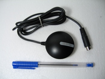
In the absence of a hand-held GPS unit it's common to see many PC and laptop users using an external GPS unit attached to the PC. These are usually available with a USB or Bluetooth interface -- the USB interface having the advantage that the USB port can power the GPS as well as read data from it. Sometimes known as hockey puck or mouse GPS receivers because of their looks and their attachment to the PC like a USB mouse, the prices of these units has come down in price to the extent where many sailing yachts carry 2 or 3 of them.
References
Forums
List links to discussion threads on partnering forums. (see link for requirements)
Links
- Global Positioning System on wikipedia
- GPS receiver on wikipedia
- Satellite navigation on wikipedia
See Also
Comments
We welcome users' contributions to the Wiki. Please click on Comments to view other users' comments, add your own personal experiences or recommend any changes to this page following your visit. Personal experience?
| This page has an outline in place but needs completing. Please contribute if you can to help it grow further. Click on Comments to suggest further content or alternatively, if you feel confident to edit this page, click on the edit tab at the top and enter your changes directly. |
| |
|---|
|
Names: Delatbabel |
.
