San Juan Islands
From CruisersWiki
| San Juan Islands
| |
The islands were part of the traditional area of the Central Coast Salish. Linguistically, the Central Coast Salish consisted of five groups: Squamish, Halkomelem, Nooksack, Northern Straits (which includes the Lummi dialect), and Klallam. Exploration and settlement by Europeans brought smallpox to the area by the 1770s. In 1843, the Hudson's Bay Company established Fort Camosun at nearby Vancouver Island.
The 1846 Oregon Treaty forced by President Polk established the 49th parallel as the boundary between Canada and the U.S., except in the San Juan archipelago. While both sides agreed that all of Vancouver Island would remain British, the treaty wording was left vague enough as to put the boundary between modern-day Gulf Islands and San Juan Islands in dispute. Conflicts over this border led to the Pig War in 1859. Skirmishes continued until the boundary issue was eventually placed in the hands of Kaiser Wilhelm I of Germany for arbitration. The border was finally established in 1872.
The name "San Juan" was given to the San Juan Islands by the Spanish explorer Francisco de Eliza, who charted the islands in 1791, naming them Isla y Archiepelago de San Juan. The expedition sailed under the authority of the Viceroy of Mexico, Juan Vicente de Güemes Padilla Horcasitas y Aguayo, 2nd Count of Revillagigedo and Eliza named several places for him, including the San Juan Islands and Orcas Island (short for "Horcasitas"). San Juan Island itself was first discovered (by a European) by one of the officers under Eliza's command, Gonzalo López de Haro (for whom Haro Strait is named). The Spanish had found the islands a year earlier during the exploring voyage of Manuel Quimper on the Princesa Real, but it was not clear that they were islands.
Subsequent explorations of the region by the British, under George Vancouver, and the Americans, under Charles Wilkes, resulted in many of the Spanish names being replaced with English ones.
Vancouver's expedition occurred within a year of Eliza's, and Vancouver encountered other Spanish ships and traded information. Thus Vancouver knew of the names given by Eliza's expedition and tended to keep them, although he renamed some things, like the Strait of Georgia. Wilkes, sailing in 1841, had some British charts, but may not have been aware of the Spanish names and charts. He liberally gave new names to nearly every coastal feature not already named on the charts he had. The names Wilkes gave tended to be patriotically American (heroes of the War of 1812 for example), or to honor members of his crew.
In 1847, due to the confusion of multiple names on different charts, the British Admiralty reorganized the official charts of the region. The project, led by Henry Kellett, applied only to British territory, which at the time included the San Juan Islands but not Puget Sound. Kellett systematically kept the British and Spanish names and removed nearly all of Wilkes' names. In some cases Kellett moved Spanish names around to replace names given by Wilkes. Thus in Puget Sound itself, the names given by Wilkes are common and Spanish names rare, while the reverse is true for the San Juan and Gulf Islands (although the Spanish did not explore Puget Sound as thoroughly as the British and Americans, resulting in fewer Spanish names to start with).
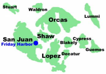
Wilkes had given the name Navy Archipelago to the San Juan Islands, and named individual islands for distinguished officers of the US Navy, such as Rodgers Island for San Juan Island, and Hull Island for Orcas Island. Some of his names survived the editing of Kellett, such as Chauncey, Shaw, Decatur, Jones, Blakely, Perry, Sinclair, Lawrence, Gordon, and Percival, all named after American naval officers.[1]
- San Juan Islands today
One of the San Juan Islands at Night
Today, the San Juan Islands are an important tourist destination, with sea kayaking and orca whale-watching by boat or air tours, two of the primary attractions. Part of the charm that attracts tourists and residents to the San Juan Islands is that each island seems to have a character of its own, both in terms of geography and of the lifestyle of the people who live there.
Politically, the bulk of the San Juan Islands make up San Juan County, Washington, though some of the furthest east of the islands are in the mainland counties of Whatcom and Skagit, including Lummi, Guemes, and Cypress Islands.
The majority of the San Juan Islands are quite hilly, the tallest mountain being Mount Constitution at almost exactly a half-mile (800 m) elevation (see Orcas Island), with some flat areas and valleys, often quite fertile, in between. The coastlines are a mixed bag of sandy and rocky beaches, shallow and deep harbors, placid and reef-studded bays. Gnarled, ochre-colored madrona trees (Arbutus) grace much of the shorelines while evergreen fir and pine forests cover large inland areas.
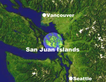
The San Juan Islands get less rainfall than Seattle, about 65 miles (105 km) to the south, due to the rain shadow of Olympic Mountains to the southwest. Summertime high temperatures are around 70 °F (21 °C) while average wintertime lows are in the high thirties and low forties. Snow is infrequent in winter except for the higher elevations, but the islands are subject to high winds at times—those from the northeast sometimes bring brief periods of freezing and Arctic-like windchills.
Beginning in about 1900 the San Juan Islands became infested with European rabbits, an exotic invasive species, as the result of the release of domestic rabbits on Smith Island. Rabbits from the San Juan Islands were used later for several introductions of European rabbits into other, usually midwestern, states.
Charts
- Source
- Chart Number - Chart Name
- Chart Number - Chart Name
- Source
- Chart Number - Chart Name
Weather
Give weather conditions in the region or refer to another page (a country?) that covers these conditions.
Sources for weather information:
Currents & Tides
Give weather conditions in the region or refer to another page (a country?) that covers these conditions.
Passages
List popular passages/routes, timing, etc.
Communication
Also see Cruiser's Nets... never heard of one, but that doesn't mean that it's not there.
VHF channel listings are as follows...
Channel Usage:
| VHF CHANNEL | VHF CHANNEL | VHF CHANNEL |
|---|---|---|
| 1A Port Operations and commercial 5A Port Operations 6 Intership safety 7A Commercial 8 Commercial (ship-to-ship only) 9 Boater Calling-Commercial/Non-commercial 10 Commercial 11 Commercial. VTS in selected areas. 12 Port Operations. VTS in areas. 13 Intership Navigation (Bridge-to-bridge) 14 Port Operations. VTS in selected areas 15 Environmental (Receive only). Used by Class C EPIRBs 16 International Distress, Safety and Calling 17 State control 18A Commercial 19A Commercial 20 Port Operations (duplex) | 20A Port Operations 21A U.S. Coast Guard only 22A U.S. Coast Guard Liaison/Maritime Safety Information Broadcasts 23A U.S. Coast Guard only 24 Public Correspondence (Marine Operator) 25 Public Correspondence (Marine Operator) 26 Public Correspondence (Marine Operator) 27 Public Correspondence (Marine Operator) 28 Public Correspondence (Marine Operator) 63A Port Operations and Commercial, VTS 65A Port Operations 66A Port Operations 67 Commercial 68 Non-Commercial 69 Non-Commercial 70 Digital Selective Calling (voice comms not allowed) 71 Non-Commercial | 72 Non-Commercial (Intership only) 73 Port Operations 74 Port Operations 77 Port Operations (ship-to-ship, to and from pilots docking ships) 78A Non-Commercial 79A Commercial. Non-Commercial in Great Lakes only 80A Commercial. Non-Commercial in Great Lakes only 81A U.S. Government only-Environmental protection operations 82A U.S. Government only 83A U.S. Coast Guard only 84 Public Correspondence (Marine Operator) 85 Public Correspondence (Marine Operator) 86 Public Correspondence (Marine Operator) 87 Public Correspondence (Marine Operator) 88 Public Correspondence only near Canadian border 88A Commercial, Intership only |
Also see transit of the Strait of Juan De Fuca
See each Island
Islands in the Group
Things to do Ashore
See individual islands.
Friends
Contact details of "Cruiser's Friends" that can be contacted for local information or assistance.
Forums
List links to discussion threads on partnering forums. (see link for requirements)
Links
- [1]
- San Juan Islands at the Wikipedia
- San Juan Islands at the Wikivoyage
References
See United States.
Comments
We welcome users' contributions to the Wiki. Please click on Comments to view other users' comments, add your own personal experiences or recommend any changes to this page following your visit.
- Just as a note I am a big believer in the "Pubs" that are supplied by NOAA, and I source much of my material from there.
Verified by
Date of member's last visit to San Juan Islands and this page's details validated:
If you provide a lot of info and this page is almost complete, change {{Page outline}} to {{Page useable}}.
| This page has an outline in place but needs completing. Please contribute if you can to help it grow further. Click on Comments to suggest further content or alternatively, if you feel confident to edit this page, click on the edit tab at the top and enter your changes directly. |
| |
|---|
|
Names: Lighthouse |

