Šibenik
From CruisersWiki
(→Eateries) |
Istioploos (Talk | contribs) (Chartlet) |
||
| Line 1: | Line 1: | ||
| - | == Sibenik | + | {{Infobox |43|43.98|N|15|53.4|E| |
| - | {| class="infobox bordered" style="width: 28em; text-align: | + | | mapzoom= 16 |
| - | + | | image= SibenikWaterfront.jpg | |
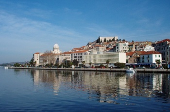
| - | + | | imagetext= Sibenik from SW - ''Click for larger view'' | |
| + | }} {{TOCleft}} | ||
| + | {| class="infobox bordered" style="width: 28em; text-align: right; font-size: 90%;" | ||
|- | |- | ||
| - | + | | colspan="2" style="text-align:center;" | <googlemap lat="43.747785" lon="15.876274" width="352" scale="yes"></googlemap> | |
| - | + | ||
| - | + | ||
| - | + | ||
| - | + | ||
| - | + | ||
| - | + | ||
| - | + | ||
| - | + | ||
| - | | colspan="2" style="text-align:center;" |<googlemap lat="43.747785" lon="15.876274" width=" | + | |
| - | </googlemap> | + | |
|} | |} | ||
| - | |||
| - | |||
The city of Sibenik lies on the Adriatic coast of [[Croatia]] on the E side of a five mile long inlet entered through a narrow strait, the Kanal Sv. Ante. The entrance is situated five miles SE of [[Vodice]] and 11 miles NNW of [[Primosten]]. A historic city with an old centre dating back to the 15th and 16th centuries, Sibenik has a remarkable 15th century barrel-vaulted cathedral of St Jakob, in itself justifying a visit. Sibenik is also a good base for a trip to the Krka National Park and its magnificent waterfalls at Skradin. Yachts have the option of berthing on the waterfront quay, where there are few facilities and shelter is poor with any winds from NW round to SE, or in the new, luxury, 350-berth [[Mandalina Marina]] a mile SSE of the quay. Further inland, eight miles up the Krka river, is another marina, [[Marina Skradin]], close to the celebrated waterfalls. | The city of Sibenik lies on the Adriatic coast of [[Croatia]] on the E side of a five mile long inlet entered through a narrow strait, the Kanal Sv. Ante. The entrance is situated five miles SE of [[Vodice]] and 11 miles NNW of [[Primosten]]. A historic city with an old centre dating back to the 15th and 16th centuries, Sibenik has a remarkable 15th century barrel-vaulted cathedral of St Jakob, in itself justifying a visit. Sibenik is also a good base for a trip to the Krka National Park and its magnificent waterfalls at Skradin. Yachts have the option of berthing on the waterfront quay, where there are few facilities and shelter is poor with any winds from NW round to SE, or in the new, luxury, 350-berth [[Mandalina Marina]] a mile SSE of the quay. Further inland, eight miles up the Krka river, is another marina, [[Marina Skradin]], close to the celebrated waterfalls. | ||
| + | |||
| + | ==Local Weather== | ||
| + | Diurnal winds along the coast are mostly moderate during the summer months, predominantly from NW and rarely exceeding force 4/5. At night, katabatic winds off the mountains are a feature of some of the harbours along the NE Adriatic coast. During early spring and (especially) autumn conditions can be more unsettled, occasionally accompanied by violent thunderstorms - luckily of short duration - with winds of 30-35 knots or more and vicious, steep seas. In the winter the sudden, violent N wind off the mountains, the ''bora'', is much to be feared, especially along the Velebitski channel. It tends to blow less strongly S of Zadar. | ||
| + | |||
| + | Equally prevalent in winter - although not uncommon in summer - is the ''scirocco'', a S/SE wind that blows up from North Africa, usually in advance of a depression moving E across the Mediterranean. Unlike the ''bora'', the ''scirocco'' only occasionally exceeds gale force, but is still a phenomenon to be wary of, especially if on a lee coast. | ||
| + | |||
| + | For sources of weather forecasting, ''see [[Croatia#Sources_of_weather_forecast_info|Croatia]]''. | ||
==Charts== | ==Charts== | ||
| Line 38: | Line 35: | ||
''Also see [[World MM Nets|World Cruiser's Nets]]''. | ''Also see [[World MM Nets|World Cruiser's Nets]]''. | ||
| - | |||
| - | |||
| - | + | ==Approach and Navigation== | |
| + | The channel of Kanal Sv. Ante is entered at {{Poi coord|43|43.2|N|15|51.0|E|}} just south of the resort of Jadrija. On the E side of the entrance is a rocky shoal, Hrid Rocni, which is marked with a light beacon and should be left to starboard. The narrow channel leads ENE for a mile before opening out into the bay of Sibenik. Note that there is a further shoal patch on the E side where the channel opens out. It is marked with a light structure. The city and its waterfront lie half a mile NE across the bay. | ||
| - | + | ==Check-in facilities (for Customs and Immigration)== | |
| + | {{GreenText|Submit details about facilities for checking in - location of immigration & customs, etc.}} | ||
| - | == | + | ==Berthing Options== |
| - | The | + | The berths at the town quay are equipped with laid moorings but little else (no water or electricity 2012). Pick up one of the moorings wherever available. Depths range from 4.0 metres at the NW end to around 2.0 metres at the SE end of the quay. First 15 minutes are free then you will be charged for a half or full day. Alternatively, seek a berth in [[Mandalina Marina]] on the S side of the small peninsula a mile to the S, where there is a full range of services. ''See [[Mandalina Marina]] entry for details''. Depths in the marina are 15.0 metres or more. Shelter on the waterfront quay is only moderate and poor in any winds from NW round to SE. In summer the sea breeze makes mooring difficult in the afternoon. The marina has excellent shelter. |
| - | == | + | ===Marinas & Yacht Clubs=== |
| - | + | * [[Mandalina Marina]] | |
| + | |||
| + | ===Anchorages=== | ||
| + | None. | ||
==Offshore Islands and Groups== | ==Offshore Islands and Groups== | ||
| - | * Prvic | + | * [[Prvic]] |
| - | * Tijat | + | * [[Tijat]] |
* [[Zlarin]] | * [[Zlarin]] | ||
* [[Zirje]] | * [[Zirje]] | ||
| - | |||
| - | |||
| - | |||
==Yacht Repairs and Services== | ==Yacht Repairs and Services== | ||
| - | See [[Mandalina Marina]]. | + | ''See [[Mandalina Marina]]''. |
====Fuel, Water, & Electricity==== | ====Fuel, Water, & Electricity==== | ||
| Line 108: | Line 105: | ||
* International buses to Vienna and several German cities. | * International buses to Vienna and several German cities. | ||
* Trains to Zagreb. | * Trains to Zagreb. | ||
| - | * International airports of Zadar (62 kms) and Split (60 kms). | + | * International airports of [[Zadar]] (62 kms) and [[Split]] (60 kms). |
==Routes/Passages To/From== | ==Routes/Passages To/From== | ||
| - | + | ''See [[Croatia#Popular_Routes.2FCruises|Croatia]]''. | |
| - | + | ||
==Cruiser's Friends== | ==Cruiser's Friends== | ||
| Line 119: | Line 115: | ||
==Forum Discussions== | ==Forum Discussions== | ||
| - | List links to discussion threads on [[Cruising Forums|partnering forums]]. (see link for requirements) | + | List links to discussion threads on [[Cruising Forums|partnering forums]]. (''see link for requirements'') |
* | * | ||
* | * | ||
| + | |||
==External Links== | ==External Links== | ||
| - | + | * {{wikipedia|Šibenik}} | |
| + | * | ||
For other useful websites, ''see [[Croatia#External_Links|Croatia]]''. | For other useful websites, ''see [[Croatia#External_Links|Croatia]]''. | ||
| Line 132: | Line 130: | ||
==Personal Notes== | ==Personal Notes== | ||
Personal experiences? | Personal experiences? | ||
| - | * | + | * |
====Last Visited & Details Checked (and updated here)==== | ====Last Visited & Details Checked (and updated here)==== | ||
| Line 140: | Line 138: | ||
| - | {{ | + | {{Page useable}} |
| - | + | {{Contributors|[[User:Atheneoflymington|Athene of Lymington]], [[User:Salacia|Salacia]]}} | |
| - | { | + | |
| - | + | ||
| - | | | + | |
| - | + | ||
| - | + | ||
| - | + | ||
| - | + | ||
| - | + | ||
| - | + | ||
| - | + | ||
| - | + | ||
| - | + | ||
| - | + | ||
| - | + | ||
| + | {{Navbar| [[Mediterranean]] | [[Adriatic Sea]] | [[Croatia]] | [[Sibenik]] }} | ||
| - | + | [[Category:Ports - Croatia]] | |
Revision as of 18:10, 19 June 2015
| Šibenik
| |
The city of Sibenik lies on the Adriatic coast of Croatia on the E side of a five mile long inlet entered through a narrow strait, the Kanal Sv. Ante. The entrance is situated five miles SE of Vodice and 11 miles NNW of Primosten. A historic city with an old centre dating back to the 15th and 16th centuries, Sibenik has a remarkable 15th century barrel-vaulted cathedral of St Jakob, in itself justifying a visit. Sibenik is also a good base for a trip to the Krka National Park and its magnificent waterfalls at Skradin. Yachts have the option of berthing on the waterfront quay, where there are few facilities and shelter is poor with any winds from NW round to SE, or in the new, luxury, 350-berth Mandalina Marina a mile SSE of the quay. Further inland, eight miles up the Krka river, is another marina, Marina Skradin, close to the celebrated waterfalls.
Local Weather
Diurnal winds along the coast are mostly moderate during the summer months, predominantly from NW and rarely exceeding force 4/5. At night, katabatic winds off the mountains are a feature of some of the harbours along the NE Adriatic coast. During early spring and (especially) autumn conditions can be more unsettled, occasionally accompanied by violent thunderstorms - luckily of short duration - with winds of 30-35 knots or more and vicious, steep seas. In the winter the sudden, violent N wind off the mountains, the bora, is much to be feared, especially along the Velebitski channel. It tends to blow less strongly S of Zadar.
Equally prevalent in winter - although not uncommon in summer - is the scirocco, a S/SE wind that blows up from North Africa, usually in advance of a depression moving E across the Mediterranean. Unlike the bora, the scirocco only occasionally exceeds gale force, but is still a phenomenon to be wary of, especially if on a lee coast.
For sources of weather forecasting, see Croatia.
Charts
- British Admiralty
- 2711
- 2773
- 2774
- Croatian chart
- 100-21
- Italian chart
- 6004
- Imray Nautical Chart
- M25
Radio Nets
Also see World Cruiser's Nets.
The channel of Kanal Sv. Ante is entered at Template:Poi coord just south of the resort of Jadrija. On the E side of the entrance is a rocky shoal, Hrid Rocni, which is marked with a light beacon and should be left to starboard. The narrow channel leads ENE for a mile before opening out into the bay of Sibenik. Note that there is a further shoal patch on the E side where the channel opens out. It is marked with a light structure. The city and its waterfront lie half a mile NE across the bay.
Check-in facilities (for Customs and Immigration)
Submit details about facilities for checking in - location of immigration & customs, etc.
Berthing Options
The berths at the town quay are equipped with laid moorings but little else (no water or electricity 2012). Pick up one of the moorings wherever available. Depths range from 4.0 metres at the NW end to around 2.0 metres at the SE end of the quay. First 15 minutes are free then you will be charged for a half or full day. Alternatively, seek a berth in Mandalina Marina on the S side of the small peninsula a mile to the S, where there is a full range of services. See Mandalina Marina entry for details. Depths in the marina are 15.0 metres or more. Shelter on the waterfront quay is only moderate and poor in any winds from NW round to SE. In summer the sea breeze makes mooring difficult in the afternoon. The marina has excellent shelter.
Marinas & Yacht Clubs
Anchorages
None.
Offshore Islands and Groups
Yacht Repairs and Services
See Mandalina Marina.
Fuel, Water, & Electricity
- Fuel
- Station at the NW end of the waterfront. This station had a reputation in making billing errors
- There is a well protected and reliable fuel station to the SE on the south side of the bay, easily recognizable by the huge "Lukoil" sign on the hillside, right opposite the entrance to the marina.
- Water
- Available from same point
- In Mandalina Marina
- Electricity
- In Mandalina Marina
Things to do Ashore
Tourism
The old town of Sibenik is full of narrow streets climbing up past the cathedral to the fortress of St Ana on a bluff at the NW end of the town. There are superb views from here of the Kornati Islands and the Sibenik channel. Sibenik’s crowning glory, however, is the 15th century cathedral of St Jakob, built entirely in stone (including the barrel-vaulted roof), whose most impressive feature is a series of 71 heads carved by an anonymous 15th century sculptor all round the north and east walls, all apparently modeled by the 15th century citizens of the town. From the town, one can also motor up the winding channel of the Krka river, hemmed in by limestone cliffs and lined with mussel farms, to the ACI marina at Skradin and the wonderful falls a few hundred metres upstream.
Grocery & Supply Stores
- Numerous supermarkets and provisions shops in the town.
- Ship chandler opposite of the fuel station.
Eateries
- Plenty of bars and restaurants in the town.
- Note in particular the Italian restaurant Pelegrini, right across the square from the St. Jacob's cathedral.
Internet/WiFi
In Mandalina Marina.
Laundry
In Mandalina Marina.
Motorbike & Car Rentals
Outlets in the city.
Garbage Disposal
Bins in the marina and behind the waterfront.
Transportation
- Buses to Zagreb and local destinations.
- International buses to Vienna and several German cities.
- Trains to Zagreb.
- International airports of Zadar (62 kms) and Split (60 kms).
Routes/Passages To/From
See Croatia.
Cruiser's Friends
Contact details of "Cruiser's Friends" that can be contacted for local information or assistance.
Forum Discussions
List links to discussion threads on partnering forums. (see link for requirements)
External Links
- Šibenik at the Wikipedia
For other useful websites, see Croatia.
References & Publications
See entry for Croatia.
Personal Notes
Personal experiences?
Last Visited & Details Checked (and updated here)
Date of member's visit to this Port/Stop & this page's details validated:
- July 2004 --Athene of Lymington 14:59, 3 August 2011 (BST)
| This is a usable page of the cruising guide. However, please contribute if you can to help it grow further. Click on Comments to add your personal notes on this page or to discuss its contents. Alternatively, if you feel confident to edit the page, click on the edit tab at the top and enter your changes directly. |
| |
|---|
|
Names: Athene of Lymington, Salacia |
| Cruising Wiki Navigation
|
|---|
| | HOMEPAGE | Wiki Contents | Mediterranean | Adriatic Sea | Croatia | Sibenik | |


