Kukljica
From CruisersWiki
Istioploos (Talk | contribs) (Move Routes) |
Istioploos (Talk | contribs) (Template) |
||
| (13 intermediate revisions not shown) | |||
| Line 1: | Line 1: | ||
| - | {{IsPartOf|Mediterranean|Adriatic Sea|Croatia|Ugljan}} | + | {{IsPartOf|Mediterranean|Adriatic Sea|Croatia|Northern Dalmatia|Ugljan}} |
{{TOC block}} | {{TOC block}} | ||
| - | {{Infobox |44 | + | |
| - | | zoom= | + | {{Infobox |
| + | | lat= 44.03367|lon=15.25217 | ||
| + | | name= Kukljica | ||
| + | | portofentry= | ||
| + | | zoom= 15 | ||
| + | | chartlet = y | ||
| image= KuklicaAerial.jpg | | image= KuklicaAerial.jpg | ||
| - | | imagetext= Kuklica harbour from S | + | | imagetext= Kuklica harbour from thr S |
| - | | | + | | summary= The port of '''Kuklica''' is located on the SE coast of the island of [[Ugljan]], just over a mile NNW of the Prolaz Mali Zdrelac, the channel between Ugljan and its neighbouring island of [[Pašman]]. Built around a natural inlet, it is sheltered from all except strong SE winds. In addition to hosting a busy fishing fleet, the harbour also caters for visiting yachts, with two concrete jetties, one on the NW side of the harbour and the other on the SW offering some 25-30 berths in total, complete with laid moorings, water, and electricity. It is also a popular tourist destination and the population of around 750 is swelled by several times that amount during the summer months. Every 5 August for the Festival of Our Lady of the Snow a statue of the Virgin is carried in procession from the eponymous chapel in the '''Prolaz Mali Ždrelac''' to Kuklica, accompanied by nearly 100 boats of all kinds. |
| + | | notes= | ||
| + | | news= | ||
}} | }} | ||
| - | |||
==Charts== | ==Charts== | ||
| - | + | ''See [[Northern Dalmatia#Charts|Northern Dalmatia]]''. | |
| - | + | ||
| - | + | ||
| - | + | ||
| - | + | ||
| - | + | ||
==Weather== | ==Weather== | ||
| - | + | ''See [[Croatia#Weather|Croatia]]''. | |
| - | + | ||
| - | + | ||
| - | + | ||
| - | + | ||
==Passages== | ==Passages== | ||
| Line 28: | Line 25: | ||
==Islands== | ==Islands== | ||
| - | * [[ | + | * [[Pašman]] |
| - | + | ||
| - | + | ||
| - | + | ||
| - | + | ||
==Communication== | ==Communication== | ||
| + | {{Green|Add here VHF channel for the coastguard, harbor masters. etc.}} | ||
* | * | ||
* | * | ||
| - | ''Also see [[ | + | ''Also see [[HF_Radio|Cruiser's Nets]]'' |
| + | |||
| + | ==Navigation== | ||
| + | There are no dangers in the approach to [[Kuklica]]. | ||
| + | |||
| + | {{Note}}If you are approaching from S, the channel of [[Ugljan#Mali Ždrelac|Prolaz Mali Ždrelac]] between [[Ugljan]] and [[Pašman]] is only navigable by yachts with an air draft of less than 16.5 metres. Depths in the harbour entrance are 5.0 - 6.0 metres. | ||
==Entrance== | ==Entrance== | ||
| Line 44: | Line 43: | ||
==Berthing== | ==Berthing== | ||
| - | + | {{Image right| KuklicaSWQuay.jpg| Moorings on the SW quay, Kuklica}} | |
| - | + | ||
| - | + | ||
| - | {{Note}} The S side of the harbour is reserved for the fishing fleet. | + | There are three principal berthing options in [[Kuklica]]: |
| + | |||
| + | # '''SW quay''' | ||
| + | #: At the SW end of the harbour — straight ahead when entering — is a long concrete jetty with laid moorings for around 20 yachts. Depths here range from just under 2.0 metres at the root to 3.5 metres at the end of the jetty. Water and electricity are available. Charges (2016): HRK 25/metre. These berths are the ones normally used by visiting yachts. Shelter here is good except in strong E or SE winds. A passenger ferry/tripper boat berths on the end of this jetty. | ||
| + | #:{{hold vertical}}{{Image right| KuklicaNWQuay.jpg| Moorings on the NW quay, Kuklica}} | ||
| + | # '''NW quay''' | ||
| + | #: There are three concrete jetties at the NW end of the harbour offering some 50-60 berths. These are normally reserved for local boats, but visiting yachts can berth if there is space on the outside of the most seaward of the jetties. Laid moorings at all berths. There are water and electricity points. Toilets and showers at the root of the jetty. Shelter is good here in most conditions, although strong SE winds can cause an unpleasant swell. | ||
| + | # '''Breakwater''' | ||
| + | #: If both jetties are full, it is possible to berth bows or stern-to the N breakwater using your anchor. Depths here are 2.5 - 3.0 metres. The holding is good in sand and weed. There are no facilities on the breakwater. | ||
| + | |||
| + | {{Note}}The S side of the harbour is reserved for the fishing fleet. | ||
===Marinas & Yacht Clubs=== | ===Marinas & Yacht Clubs=== | ||
None. | None. | ||
| - | + | ==Anchorages== | |
| - | The nearest suitable anchorage is on the E side of the | + | The nearest suitable anchorage is on the E side of the [[Ugljan#U. Zdrelašćica|Prolaz Mali Ždrelac]]. |
| - | == | + | ==Amenities== |
| - | + | {{tlist | |
| - | + | |header|Facilities | |
| - | + | ||
| - | == | + | |Water| |
| - | ==== | + | {{mark | type= water |name=On the SW jetties | lat= 44.03431|lon=15.24822|zoom=17}} |
| - | {{ | + | {{mark | type= water |name=On the NW jetties | lat= 44.03536|lon=15.24858|zoom=17}} |
| + | |Electricity| | ||
| + | {{mark | type= electricity |name=On the SW jetties | lat= 44.03431|lon=15.24822|zoom=17}} | ||
| + | {{mark | type= electricity |name=On the NW jetties | lat= 44.03536|lon=15.24858|zoom=17}} | ||
| + | |Toilets| On the root of the NW jetties | ||
| + | |Showers|On the root of the NW jetties | ||
| + | |Laundry| N/A (Not Available) | ||
| + | |Garbage| Near the harbour | ||
| - | + | |header|Supplies | |
| + | |Fuel| N/A | ||
| + | |Bottled gas| None | ||
| + | |Chandlers| None | ||
| - | ==== | + | |header|Services |
| - | + | |Repairs| {{mark | type= service |name= Kuklica yard | lat= 44.03414|lon=15.2473|zoom=17 |text= small boatyard in the town offering basic repairs}} | |
| + | |Internet| N/A | ||
| + | |Mobile connectivity| {{Green|Is there mobile telephone signal such as G4, G3, GPRS on the island? How strong is the signal? Are there any blind spots?}} | ||
| + | |Vehicle rentals| N/A | ||
| + | }} | ||
| - | ==== | + | ==Provisioning== |
| + | Supermarket and other provisions shops in the town. | ||
| + | |||
| + | ==Eating out== | ||
Numerous restaurants ashore. | Numerous restaurants ashore. | ||
| - | + | ==Transportation== | |
| - | + | ||
| - | + | ||
| - | + | ||
Buses to local destinations. | Buses to local destinations. | ||
| - | == | + | ==Tourism== |
| + | {{Image right| KuklicaFestival.jpg| The Festival of Our Lady of the Snow, Kuklica}} | ||
| + | ====Places to Visit==== | ||
| + | The town has a busy tourist industry and its old centre on the S side of the has a number of fine old buildings. There are some good walks in the surrounding pine woods and nice beaches within easy walking distance. In the cove of Kostanj, 15 minutes on foot N from the harbour, there is an excellent beach and a 13th century church of St Jerome. | ||
| + | |||
| + | ==Friends== | ||
Contact details of "Cruiser's Friends" that can be contacted for local information or assistance. | Contact details of "Cruiser's Friends" that can be contacted for local information or assistance. | ||
* | * | ||
| - | == | + | ==Forums== |
List links to discussion threads on [[Cruising Forums|partnering forums]]. (''see link for requirements'') | List links to discussion threads on [[Cruising Forums|partnering forums]]. (''see link for requirements'') | ||
* | * | ||
==Links== | ==Links== | ||
| - | * {{wikipedia | + | * {{wikipedia}} |
| - | * [http://www.ugljan.hr | + | * [http://www.ugljan.hr Ugljan Tourism] |
* | * | ||
For other useful websites, ''see [[Croatia#Links|Croatia]]''. | For other useful websites, ''see [[Croatia#Links|Croatia]]''. | ||
| - | ==References | + | ==References== |
| - | ''See [[Croatia#References | + | ''See [[Croatia#References|Croatia]]''. |
| - | {{Comments | + | {{Comments}} |
* | * | ||
* | * | ||
{{Verified by}} | {{Verified by}} | ||
| - | * | + | * July 2016 --[[User:Atheneoflymington|Athene of Lymington]] |
* | * | ||
Latest revision as of 22:16, 18 March 2019
| Kukljica
| |
| |
 Kuklica harbour from thr S |
The port of Kuklica is located on the SE coast of the island of Ugljan, just over a mile NNW of the Prolaz Mali Zdrelac, the channel between Ugljan and its neighbouring island of Pašman. Built around a natural inlet, it is sheltered from all except strong SE winds. In addition to hosting a busy fishing fleet, the harbour also caters for visiting yachts, with two concrete jetties, one on the NW side of the harbour and the other on the SW offering some 25-30 berths in total, complete with laid moorings, water, and electricity. It is also a popular tourist destination and the population of around 750 is swelled by several times that amount during the summer months. Every 5 August for the Festival of Our Lady of the Snow a statue of the Virgin is carried in procession from the eponymous chapel in the Prolaz Mali Ždrelac to Kuklica, accompanied by nearly 100 boats of all kinds.
Charts
See Northern Dalmatia.
Weather
See Croatia.
Passages
See Croatia.
Islands
Communication
Add here VHF channel for the coastguard, harbor masters. etc.
Also see Cruiser's Nets
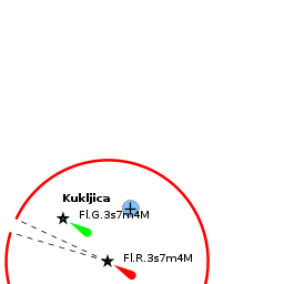
There are no dangers in the approach to Kuklica.
Note: If you are approaching from S, the channel of Prolaz Mali Ždrelac between Ugljan and Pašman is only navigable by yachts with an air draft of less than 16.5 metres. Depths in the harbour entrance are 5.0 - 6.0 metres.
Entrance
The nearest year-round port of entry is Zadar.
Berthing

There are three principal berthing options in Kuklica:
- SW quay
- At the SW end of the harbour — straight ahead when entering — is a long concrete jetty with laid moorings for around 20 yachts. Depths here range from just under 2.0 metres at the root to 3.5 metres at the end of the jetty. Water and electricity are available. Charges (2016): HRK 25/metre. These berths are the ones normally used by visiting yachts. Shelter here is good except in strong E or SE winds. A passenger ferry/tripper boat berths on the end of this jetty.
 Moorings on the NW quay, Kuklica
- NW quay
- There are three concrete jetties at the NW end of the harbour offering some 50-60 berths. These are normally reserved for local boats, but visiting yachts can berth if there is space on the outside of the most seaward of the jetties. Laid moorings at all berths. There are water and electricity points. Toilets and showers at the root of the jetty. Shelter is good here in most conditions, although strong SE winds can cause an unpleasant swell.
- Breakwater
- If both jetties are full, it is possible to berth bows or stern-to the N breakwater using your anchor. Depths here are 2.5 - 3.0 metres. The holding is good in sand and weed. There are no facilities on the breakwater.

Note: The S side of the harbour is reserved for the fishing fleet.
Marinas & Yacht Clubs
None.
Anchorages
The nearest suitable anchorage is on the E side of the Prolaz Mali Ždrelac.
Amenities
| Facilities | |
|---|---|
| Water |
|
| Electricity |
|
| Toilets | On the root of the NW jetties |
| Showers | On the root of the NW jetties |
| Laundry | N/A (Not Available) |
| Garbage | Near the harbour |
| Supplies | |
| Fuel | N/A |
| Bottled gas | None |
| Chandlers | None |
| Services | |
| Repairs | |
| Internet | N/A |
| Mobile connectivity | Is there mobile telephone signal such as G4, G3, GPRS on the island? How strong is the signal? Are there any blind spots? |
| Vehicle rentals | N/A |
Provisioning
Supermarket and other provisions shops in the town.
Eating out
Numerous restaurants ashore.
Transportation
Buses to local destinations.
Tourism

Places to Visit
The town has a busy tourist industry and its old centre on the S side of the has a number of fine old buildings. There are some good walks in the surrounding pine woods and nice beaches within easy walking distance. In the cove of Kostanj, 15 minutes on foot N from the harbour, there is an excellent beach and a 13th century church of St Jerome.
Friends
Contact details of "Cruiser's Friends" that can be contacted for local information or assistance.
Forums
List links to discussion threads on partnering forums. (see link for requirements)
Links
- Kukljica at the Wikipedia
- Ugljan Tourism
For other useful websites, see Croatia.
References
See Croatia.
Comments
We welcome users' contributions to the Wiki. Please click on Comments to view other users' comments, add your own personal experiences or recommend any changes to this page following your visit.
Verified by
Date of member's last visit to Kukljica and this page's details validated:
- July 2016 --Athene of Lymington
| This is a usable page of the cruising guide. However, please contribute if you can to help it grow further. Click on Comments to add your personal notes on this page or to discuss its contents. Alternatively, if you feel confident to edit the page, click on the edit tab at the top and enter your changes directly. |
| |
|---|
|
Names: Athene of Lymington |