Pantelleria
From CruisersWiki
Pantelleria
| | |
| | 36°50.0′N, 11°56.2′E |
|---|---|
| | Photo gallery |
| | Local chartlet |
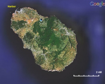
 Satellite Image of Pantelleria - Click for larger view Satellite Image of Pantelleria - Click for larger view
| |
|
Pantelleria was called in antiquity Cossyra. It was a Carthaginian colony until 255 BC when the Romans occupied it. They used it as a place for exile. In 700 AD the Christian inhabitants were annihilated by the Arabs who possessed the island until 1123 when it was captured by Roger of Sicily. Then in 1311 it was taken by the Spanish and in 1553 by the Ottomans.
There are a number of prehistoric tombs, known as sesi, similar to the Nuraghe in Sardinia. There are also several Punic (Phoenician) tombs and walls.
Weather
See Italy.
Charts
- BA
- 176 - Cap Bon to Ra's At Tin
- 193 - Sicily: Islands in the Sicilian Channel
- NIMA
- 53220 - Strait of Sicily-Southern Reaches
- 53223 - Isola di Pantelleria
Radio Nets
Also see World Cruiser's Nets.
The approaches to Pantelleria are straightforward, there no dangers.
Berthing Option
Ports
Porto Vecchio
![]() 36°50.0′N, 11°56.2′E
36°50.0′N, 11°56.2′E
Pantelleria's harbor, Porto Vecchio, can be crowded. Go to the SE side (Porto Nuovo).
You usually have to anchor and moor stern-to. Avoid the military area to the east.
Anchorages
None.
Marinas & Yacht Clubs
None.
Offshore Islands
Yacht Services and Repairs
None.
Marine Stores
None.
Repairs/Yards
None.
Fuel, Water, & Electricity
- Fuel
- From fuel stations, you will have to carry jerry cans. Note there are only 2 fuel stations on the whole island, both around the harbour.
- Water
- There is a water pipe on the dock, but it is not drinking water. Low pressure, but could be used for washing down your boat or doing laundry
- Electricity
- N/A
Things to do Ashore
Tourism
There are several interesting places in the island to visit by car.
Grocery & Supply Stores
- A few minutes walk from Porto Nuovo, at the waterfront, there is an excellent food store.
Eateries
- Good sea food in several restaurants
Internet/WiFi
Available?
Laundry
?
Motorbike & Car Rentals
In town.
Garbage Disposal
There are bins around the harbors and in several anchorages.
Transportation
There are daily ferries to Sicily.
Routes/Passages To/From
See Aegean to West Mediterranean Passages.
Cruiser's Friends
Contact details of "Cruiser's Friends" that can be contacted for local information or assistance.
Forum Discussions
List links to discussion threads on partnering forums. (see link for requirements)
External Links
- Pantelleria (Wikipedia)
- Pantelleria
References & Publications
See Italy.
Personal Notes
Personal experiences?
Last Visited & Details Checked (and updated here)
Date of member's visit to this Port/Stop & this page's details validated:
- June 2001 --Istioploos 16:31, 15 July 2008 (MDT)
|
|---|
|
Names: Lighthouse, Istioploos, Athene of Lymington |
| |
|---|
| | HOMEPAGE | Wiki Contents | Mediterranean | Italy | Sicily | Pantelleria | |

