Aegean Sea
From CruisersWiki
(Difference between revisions)
Lighthouse (Talk | contribs) (Additions) |
Istioploos (Talk | contribs) (New Material (not done yet)) |
||
| Line 1: | Line 1: | ||
===AEGEAN SEA CRUISING GUIDE=== | ===AEGEAN SEA CRUISING GUIDE=== | ||
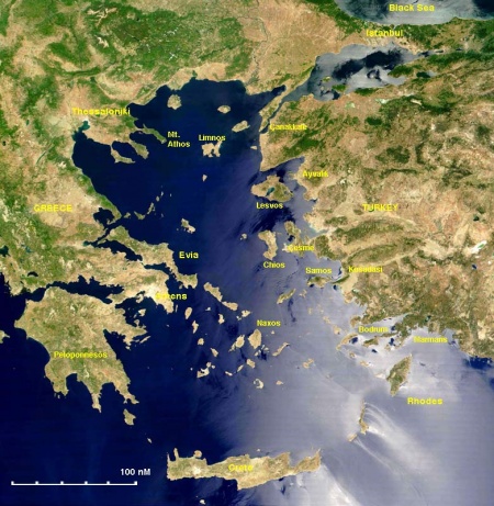
| + | [[Image:Aegeansea.jpg|thumb|450px|right|The Aegean Sea<br/>''Click for larger view'']] | ||
An online cruising guide for yachts sailing in the Aegean Sea. | An online cruising guide for yachts sailing in the Aegean Sea. | ||
| - | + | ||
===Background=== | ===Background=== | ||
| + | The [http://en.wikipedia.org/wiki/Aegean_Sea Aegean Sea] is not only the cradle of western civilization but also one of the world's premier cruising regions because of its many anchorages and historical sites. | ||
| + | The Aegean Sea has an area of 214,000 km<sup>2</sup>. Its north-south axis is 330 nM and its east-west axis 162 nM. Other then its Greek and Turkish shore lines it consists of 1,415 islands and islets most of them belonging to [[Greece]]. It is a deep sea with a maximum depth of 3,543 m (11,624 ft). | ||
===Charts=== | ===Charts=== | ||
| - | * BA | + | * BA 180 Aegean Sea |
| + | * | ||
| + | * Imray-Tetra G1 Mainland Greece and Peloponnisos | ||
| + | * Imray-Tetra G2 Aegean Sea (North Part) | ||
| + | * Imray-Tetra G3 Southern Aegean | ||
* | * | ||
* NIMA | * NIMA | ||
* | * | ||
| - | * Greek | + | * Greek 47 Aigaio Sea - Northern Part |
| + | * Greek 4 Aigaio Sea -Southern part | ||
* | * | ||
| - | * | + | * Turkey 20Aegean Sea |
===Radio Nets=== | ===Radio Nets=== | ||
| Line 58: | Line 66: | ||
===External Links=== | ===External Links=== | ||
| - | * [http://en.wikipedia.org/wiki/ | + | * [http://en.wikipedia.org/wiki/Aegean_Sea Aegean Sea] (Wikipedia) |
* | * | ||
Revision as of 16:42, 4 January 2009
Contents |
AEGEAN SEA CRUISING GUIDE
An online cruising guide for yachts sailing in the Aegean Sea.
Background
The Aegean Sea is not only the cradle of western civilization but also one of the world's premier cruising regions because of its many anchorages and historical sites.
The Aegean Sea has an area of 214,000 km2. Its north-south axis is 330 nM and its east-west axis 162 nM. Other then its Greek and Turkish shore lines it consists of 1,415 islands and islets most of them belonging to Greece. It is a deep sea with a maximum depth of 3,543 m (11,624 ft).
Charts
- BA 180 Aegean Sea
- Imray-Tetra G1 Mainland Greece and Peloponnisos
- Imray-Tetra G2 Aegean Sea (North Part)
- Imray-Tetra G3 Southern Aegean
- NIMA
- Greek 47 Aigaio Sea - Northern Part
- Greek 4 Aigaio Sea -Southern part
- Turkey 20Aegean Sea
Radio Nets
Also see World Cruiser's Nets
Submit details of local radio Nets.
Weather and Winds
Details?
Sources for weather information:
Countries (and Ports)
| Greece | Turkey |
|---|---|
Entry/Exit
Islands and Groups
Passages
Popular passages & best timing, etc.
Forum Discussions
List links to discussion threads on the Cruiser Log Forum
References & Publications
External Links
- Aegean Sea (Wikipedia)
Personal Notes
| |
|---|
| | HOMEPAGE | Wiki Contents | Mediterranean | Greece | Turkey | Aegean Sea | |
.
