Sao Vicente
From CruisersWiki
Istioploos (Talk | contribs) (Replaces São Vicente) |
Istioploos (Talk | contribs) (Coords & minor edits) |
||
| Line 1: | Line 1: | ||
==São Vicente== | ==São Vicente== | ||
| - | + | GPS: {{Coord|16|53.2|N|24|59.5|W|}} | |
[[Image:CV_MindeloS.jpg|350px|thumb|right|Satellite Image of Mindelo<br/>''Click for larger view'']] | [[Image:CV_MindeloS.jpg|350px|thumb|right|Satellite Image of Mindelo<br/>''Click for larger view'']] | ||
| Line 24: | Line 24: | ||
====Porto Grande Bay==== | ====Porto Grande Bay==== | ||
[[Image:CV_PortoGrande.jpg|350px|thumb|right|Porto Grande Bay<br/><span style="font-size: 80%;">Courtesy of Manos Castrinakis</span><br/>''Click for larger view'']] | [[Image:CV_PortoGrande.jpg|350px|thumb|right|Porto Grande Bay<br/><span style="font-size: 80%;">Courtesy of Manos Castrinakis</span><br/>''Click for larger view'']] | ||
| - | There is plenty of room in Porto Grande Bay | + | GPS: {{Coord|16|53.2|N|24|59.5|W|}}<br/> |
| + | There is plenty of room in Porto Grande Bay. Anchor in 4.5 m depth. The bottom is sand and mud and provides good holding. Anchoring here is free. | ||
<font color="red">Warning:</font> It can get very windy and gusty in the bay. This is usually caused by a strong easterly wind from Africa the ''Hamadam'' that often brings very bad dust and frequently blows for 5-10 days. | <font color="red">Warning:</font> It can get very windy and gusty in the bay. This is usually caused by a strong easterly wind from Africa the ''Hamadam'' that often brings very bad dust and frequently blows for 5-10 days. | ||
| Line 108: | Line 109: | ||
===Last Visited & Details Checked (and updated here)=== | ===Last Visited & Details Checked (and updated here)=== | ||
''Date of member's visit to this Port/Stop & this page's details validated'': | ''Date of member's visit to this Port/Stop & this page's details validated'': | ||
| - | * January 2005 --[[User:Istioploos|Istioploos]] | + | * January 2005 --[[User:Istioploos|Istioploos]] [[Image:Greece_Icon.png]] |
* | * | ||
| Line 115: | Line 116: | ||
| - | < | + | {|id="mp-right" width="100%" cellpadding="2" cellspacing="5" style="vertical-align:top; background:#f5faff;" |
| - | + | ! <h2 id="mp-itn-h2" style="margin:0; background:#cedff2; font-size:120%; font-weight:bold; border:1px solid #a3b0bf; text-align:left; color:#000; padding:0.2em 0.4em;">Page Navigation</h2> | |
| + | |- | ||
| + | |style="color:#000;"| | [[Cruising_and_Sailing_Wiki_by_CruiserLog|HOMEPAGE]] | [[Cruising|Wiki Contents]] | [[North_Atlantic|North Atlantic]] | [[Cape Verde]] | [[Sao Vicente]] | | ||
| + | |} | ||
| + | |||
. | . | ||
Revision as of 21:02, 10 March 2009
São Vicente
GPS: 16°53.2′N, 24°59.5′W
Background
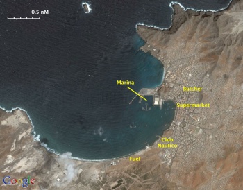
The main town, and port of the island is Mindelo. Mindelo is the name of the town in the Porto Grande Bay. It is a very safe anchorage. Most commercial ships anchor off in the large bay. There two possibilities here: anchor off or dock at the yacht marina.
Charts
See Cape Verde.
Radio Nets
Also see Cruiser's Nets
- GSM/GPRS - While there is voice signal, service is not available for most European registered phones
Approach to Mindelo from the N, via the São Vicente - Santo Antão channel, can be tricky because of several small islands and rocks near São Vicente.
Warning: There can be accelerated winds across the São Vicente - Santo Antão channel resulting in steep seas especially when blowing against the south going current.
Check-in facilities
See Cape Verde.
Ports and Popular Stops
Porto Grande Bay
GPS: 16°53.2′N, 24°59.5′W
There is plenty of room in Porto Grande Bay. Anchor in 4.5 m depth. The bottom is sand and mud and provides good holding. Anchoring here is free.
Warning: It can get very windy and gusty in the bay. This is usually caused by a strong easterly wind from Africa the Hamadam that often brings very bad dust and frequently blows for 5-10 days.
Caution: Secure your dinghy or retain the services of Umberto, who seems to be in charge of a sizable cadre of "dinghy watchers" because theft is not uncommon here.
Marinas & Yacht Clubs
Anchorages
List details of all safe anchorages in the area.
Offshore Islands
List Islands
Routes/Passages To/From
Popular passages/routes, timing, etc.
Tourism & things to do ashore
The town of Mindelo is interesting to walk around. Particularly interesting is the fish market, by the waterfront, and the the Mercado Municipal near the Governor's Palace.
Fuel, Water, & Electricity
- There is a fuel station along the beech in Mindelo where you can take jerry cans with the dinghy
- Water: Either at the Club Nautico or at the marina
- Electricity only at the marina
Laundry
In the town and at the Club Nautico.
Grocery Stores
Provisions in general are meager. There is, however, a supermarket, a few blocks inland from the Policia Maritima, they will deliver to the marina. We were able to find only one butcher store, further inland from the supermarket.
Eateries
- Good food at Nella's
- Reasonable food at the Club Nautico
Motorbike & Car Rentals
?
Marine Stores & Facilities
Repairs
Transportation
There are flights to Portugal.
References & Publications
See Cape Verde.
Cruiser's Friends
Contact details of "Cruiser's Friends" that can be contacted for local information or assistance.
Forum Discussions
List links to discussion threads on the Cruiser Log Forum
External Links
- Mindelo (Wikipedia)
Personal Notes
Personal experiences?
Last Visited & Details Checked (and updated here)
Date of member's visit to this Port/Stop & this page's details validated:
- January 2005 --Istioploos

| |
|---|
| | HOMEPAGE | Wiki Contents | North Atlantic | Cape Verde | Sao Vicente | |
.


