Žuljana
From CruisersWiki
m |
Istioploos (Talk | contribs) (Template) |
||
| Line 1: | Line 1: | ||
| - | {{IsPartOf|Mediterranean|Adriatic Sea|Croatia|Southern Dalmatia| | + | {{IsPartOf|Mediterranean|Adriatic Sea|Croatia|Southern Dalmatia|Pelješac}} |
{{TOC block}} | {{TOC block}} | ||
| + | |||
{{Infobox | {{Infobox | ||
| - | | lat=42. | + | | lat=42.89202|lon=17.45095 |
| + | | name= Žuljana | ||
| zoom= 14 | | zoom= 14 | ||
| image= ZuljanaAerial.jpg | | image= ZuljanaAerial.jpg | ||
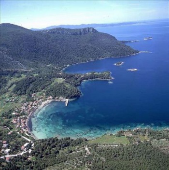
| - | | imagetext= | + | | imagetext= Žuljana from the N |
| chartlet=y | | chartlet=y | ||
| - | | summary= | + | | summary=The bay and harbour of [[Zuljana]] lie on the S coast of the [[Pelješac|Pelješac Peninsula]] on the Adriatic coast of [[Croatia]], three miles SE of the bay of [[Trstenik]], 12 miles due E of the island of [[Korčula]] and eight miles N of the island of [[Mljet]]. The hamlet sits at the end of a steep valley between high mountains and has some beautiful beaches in the near vicinity. |
| - | The bay and harbour of Zuljana lie on the S coast of the | + | |
| - | Visiting yachts can either tie up alongside or stern/bows-to on the inside of the short jetty on the S side of the bay, or anchor off the beach. An even better anchorage is in the bay of Vucine round the headland immediately S of Zuljana (although care is needed to avoid the numerous rocks in the approach). | + | Visiting yachts can either tie up alongside or stern/bows-to on the inside of the short jetty on the S side of the bay, or anchor off the beach. An even better anchorage is in the bay of [[#Vucine Bay|Vucine]] round the headland immediately S of Zuljana (although care is needed to avoid the numerous rocks in the approach). The shelter is good in the prevailing winds, but the bay is completely open to westerlies, which send in a heavy swell. It is not a good place to be in a very strong ''bora'' (which fortunately only usually occurs in winter), as it tends to funnel down the valley. |
| + | | notes= | ||
| + | | news= | ||
}} | }} | ||
==Charts== | ==Charts== | ||
| - | + | ''See [[Southern Dalmatia#Charts|Southern Dalmatia]]''. | |
| - | | | + | |
| - | + | ||
| - | + | ||
| - | + | ||
==Weather== | ==Weather== | ||
| Line 27: | Line 26: | ||
==Islands== | ==Islands== | ||
| - | * [[ | + | * [[Korčula]] |
* [[Mljet]] | * [[Mljet]] | ||
* [[Lastovo]] | * [[Lastovo]] | ||
==Communication== | ==Communication== | ||
| + | {{Green|Add here VHF channel for the coastguard, harbor masters. etc.}} | ||
* | * | ||
| + | * | ||
''Also see [[World MM Nets|World Cruiser's Nets]]''. | ''Also see [[World MM Nets|World Cruiser's Nets]]''. | ||
==Navigation== | ==Navigation== | ||
| - | The bay is tucked into NE corner of the three mile-wide bay of Zuljana. | + | The bay is tucked into NE corner of the three-mile-wide bay of [[Zuljana]]. The hamlet is clearly identifiable from the valley in which it sits, between two steep mountain. There are numerous rocks and islets off [[#Vucine Bay|Vucine Bay]] in the approach from the S and there are similar rocks close inshore in the approach from the NW. An approach from due W avoids all these dangers. |
==Berthing== | ==Berthing== | ||
| - | {{ | + | {{poi | lat= 42.89104|lon=17.45243 |
| - | The best place to moor is alongside or stern/bows-to the inner, E side of the stone jetty at the S end of the bay, where depths range from 2.0 metres at the root to 6.0 metres at the end. | + | | type= harbour |
| + | | name= Žuljana Jetty | ||
| + | | altname= | ||
| + | | url = | ||
| + | | zoom= 16 | ||
| + | | portofentry= | ||
| + | | image= ZuljanaWaterfront.jpg | ||
| + | | imagetext= Žuljana waterfront | ||
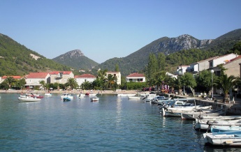
| + | | text= The best place to moor is alongside or stern/bows-to the inner, E side of the stone jetty at the S end of the bay, where depths range from 2.0 metres at the root to 6.0 metres at the end. This spot is occasionally busy with charter flotillas, which visit the bay on a regular basis in the season. | ||
| + | }} | ||
| + | ===Marinas & Yacht Clubs=== | ||
| + | None. | ||
| + | |||
| + | {{hold vertical}} | ||
==Anchorages== | ==Anchorages== | ||
| - | {{ | + | {{poi | lat=42.8856|lon=17.44878 |
| + | | type= anchorage | ||
| + | | name=Vucine Bay | ||
| + | | altname= | ||
| + | | url = | ||
| + | | zoom= 16 | ||
| + | | image= VucineBay.jpg | ||
| + | | imagetext= Idyllic scenery in Vucine bay | ||
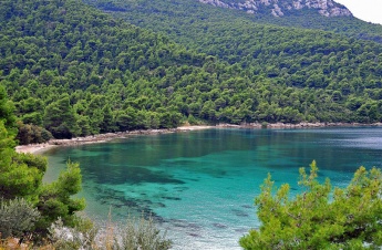
| + | | text= If there is no space at the [[#Žuljana Jetty|Žuljana Jetty]], anchor off here in the beach in 5.0 - 6.0 metres. Holding here is good in sand. The tree-lined cove of Vucine, round the headland immediately S of Žuljana is an idyllic anchorage, with a sandy bottom and water clear as glass. Great care is needed, however, to avoid the numerous rocks in the approach and it is wise, unless you have local knowledge or a large-scale chart, to proceed slowly with someone on the bow. Anchor wherever there in space. The bottom is sand and good holding. Shelter in both Zuljana and Vucine is good in the prevailing winds but poor in westerlies. | ||
| + | }} | ||
| - | |||
==Amenities== | ==Amenities== | ||
| - | + | None. | |
| - | + | ||
| - | + | ||
| - | + | ||
| - | + | ||
| - | + | ||
| - | + | ||
| - | + | ||
| - | + | ||
| - | + | ||
| - | + | ||
| - | + | ||
| - | + | ||
| - | + | ||
| - | + | ||
| - | + | ||
| - | + | ||
| - | + | ||
| - | + | ||
| - | + | ||
| - | + | ||
| - | + | ||
| - | + | ||
| - | + | ||
| - | + | ||
| - | + | ||
==Provisioning== | ==Provisioning== | ||
| - | Supermarket and small provisions shop | + | {{mark | type= provisions |name= In the Village |text= Supermarket and small provisions shop.}} |
==Eating out== | ==Eating out== | ||
| - | Café/bar and restaurant. | + | * In the Village |
| + | : {{mark |name= | type= eatingout | text=Café/bar and a restaurant.}} | ||
==Transportation== | ==Transportation== | ||
* Buses to local destinations | * Buses to local destinations | ||
| - | * Ferries to [[ | + | * Ferries to [[Korčula]] |
==Tourism== | ==Tourism== | ||
| Line 90: | Line 88: | ||
==Links== | ==Links== | ||
| - | * {{wikipedia | + | * {{wikipedia}} |
* | * | ||
| Line 98: | Line 96: | ||
''See [[Croatia#References|Croatia]]''. | ''See [[Croatia#References|Croatia]]''. | ||
| - | {{Comments | + | {{Comments}} |
| + | * | ||
| + | * | ||
{{Verified by}} | {{Verified by}} | ||
Revision as of 19:31, 3 May 2019
| Žuljana
| |
| | |
The bay and harbour of Zuljana lie on the S coast of the Pelješac Peninsula on the Adriatic coast of Croatia, three miles SE of the bay of Trstenik, 12 miles due E of the island of Korčula and eight miles N of the island of Mljet. The hamlet sits at the end of a steep valley between high mountains and has some beautiful beaches in the near vicinity.
Visiting yachts can either tie up alongside or stern/bows-to on the inside of the short jetty on the S side of the bay, or anchor off the beach. An even better anchorage is in the bay of Vucine round the headland immediately S of Zuljana (although care is needed to avoid the numerous rocks in the approach). The shelter is good in the prevailing winds, but the bay is completely open to westerlies, which send in a heavy swell. It is not a good place to be in a very strong bora (which fortunately only usually occurs in winter), as it tends to funnel down the valley.
Charts
See Southern Dalmatia.
Weather
See Croatia.
Passages
See Croatia.
Islands
Communication
Add here VHF channel for the coastguard, harbor masters. etc.
Also see World Cruiser's Nets.
The bay is tucked into NE corner of the three-mile-wide bay of Zuljana. The hamlet is clearly identifiable from the valley in which it sits, between two steep mountain. There are numerous rocks and islets off Vucine Bay in the approach from the S and there are similar rocks close inshore in the approach from the NW. An approach from due W avoids all these dangers.
Berthing
Žuljana Jetty
Marinas & Yacht Clubs
None.
Anchorages
Vucine Bay
Amenities
None.
Provisioning
![]() In the Village [[Žuljana#In the Village|In the Village]] Supermarket and small provisions shop.
In the Village [[Žuljana#In the Village|In the Village]] Supermarket and small provisions shop.
Eating out
- In the Village
-
 [[Žuljana# | ]] Café/bar and a restaurant.
Transportation
- Buses to local destinations
- Ferries to Korčula
Tourism
The main appeal of Zuljana is its beautiful beach, which is very popular in summer. The bay of Vucine is also wonderful and equally popular with tourists. At least at anchor one is away from the worst of the crowds.
Links
- Žuljana at the Wikipedia
For other useful websites, see Croatia.
References
See Croatia.
Comments
We welcome users' contributions to the Wiki. Please click on Comments to view other users' comments, add your own personal experiences or recommend any changes to this page following your visit.
Verified by
Date of member's last visit to Žuljana and this page's details validated:
- Data compiled from web research (please update if possible)--Athene of Lymington 17:32, 9 August 2011 (BST)
| This page has an outline in place but needs completing. Please contribute if you can to help it grow further. Click on Comments to suggest further content or alternatively, if you feel confident to edit this page, click on the edit tab at the top and enter your changes directly. |
| |
|---|
|
Names: Haiqu, Athene of Lymington |


