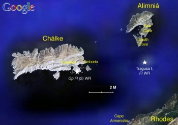
Alimnia
From CruisersWiki
m (Bot: Automated text replacement (-mapzoom +zoom)) |
m (bot: Removing Click) |
||
| Line 6: | Line 6: | ||
| zoom= 12 | | zoom= 12 | ||
| image= Greece_Chalke_S.jpg | | image= Greece_Chalke_S.jpg | ||
| - | | imagetext= Satellite View of Chalki & Alimnia | + | | imagetext= Satellite View of Chalki & Alimnia |
}} | }} | ||
Alimniá (Αλιμνιά) is a small uninhabited island located approximately 3 nM west of [[Rhodes]]. It is a most pleasant green island, with the ruins of a [http://en.wikipedia.org/wiki/Fourth_Crusade Crusader] castle, marred only by the heavy flotsam accumulated on its otherwise lovely beaches. The island was inhabited until [http://en.wikipedia.org/wiki/World_War_II World War II] when the Italians used its deep harbor as a submarine base. The islanders abandoned their island in 1943 after the British commandos sent to sabotage the submarines were captured and executed by the [http://en.wikipedia.org/wiki/Nazism Nazis]. | Alimniá (Αλιμνιά) is a small uninhabited island located approximately 3 nM west of [[Rhodes]]. It is a most pleasant green island, with the ruins of a [http://en.wikipedia.org/wiki/Fourth_Crusade Crusader] castle, marred only by the heavy flotsam accumulated on its otherwise lovely beaches. The island was inhabited until [http://en.wikipedia.org/wiki/World_War_II World War II] when the Italians used its deep harbor as a submarine base. The islanders abandoned their island in 1943 after the British commandos sent to sabotage the submarines were captured and executed by the [http://en.wikipedia.org/wiki/Nazism Nazis]. | ||
| Line 47: | Line 47: | ||
| zoom= 17 | | zoom= 17 | ||
| image= Greece_Alimnia_h.jpg | | image= Greece_Alimnia_h.jpg | ||
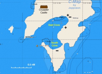
| - | | imagetext= Chart of of the coves at Alimnia | + | | imagetext= Chart of of the coves at Alimnia |
}} | }} | ||
There are two very attractive anchorages in Alimniá. | There are two very attractive anchorages in Alimniá. | ||
| - | {{image center|Greece_Alimnia2.jpg |Both East and South Coves (from the Castle) | + | {{image center|Greece_Alimnia2.jpg |Both East and South Coves (from the Castle) |400px }} |
{| class="wikitable" align=right | {| class="wikitable" align=right | ||
|- | |- | ||
| - | |[[Image:Greece_Alimnia5.jpg|250px]]<br/><small>The more protected South Cove | + | |[[Image:Greece_Alimnia5.jpg|250px]]<br/><small>The more protected South Cove</small> |
|- | |- | ||
| - | |[[Image:Greece_Alimnia1.jpg|250px]]<br/><small>The East Cove & its ruins | + | |[[Image:Greece_Alimnia1.jpg|250px]]<br/><small>The East Cove & its ruins</small> |
|} | |} | ||
| Line 87: | Line 87: | ||
|- | |- | ||
| - | |[[Image:Greece_Alimni_Cartoon.jpg|200px]]<br /><small>WWII Cartoon | + | |[[Image:Greece_Alimni_Cartoon.jpg|200px]]<br /><small>WWII Cartoon</small> |
|- | |- | ||
| - | |[[Image:Greece_Alimnia6.jpg|200px]]<br /><small>The Castle | + | |[[Image:Greece_Alimnia6.jpg|200px]]<br /><small>The Castle</small> |
|- | |- | ||
| - | |[[Image:Greece_Alimnia7.jpg|200px]]<br /><small>The Castle, again | + | |[[Image:Greece_Alimnia7.jpg|200px]]<br /><small>The Castle, again</small> |
|- | |- | ||
| - | |[[Image:Greece_Alimnia3.jpg|200px]]<br /><small>In the Castle | + | |[[Image:Greece_Alimnia3.jpg|200px]]<br /><small>In the Castle</small> |
|- | |- | ||
| - | |[[Image:Greece_Alimnia4.jpg|200px]]<br /><small>Flotsam in the Beach (East Cove) | + | |[[Image:Greece_Alimnia4.jpg|200px]]<br /><small>Flotsam in the Beach (East Cove)</small> |
|} | |} | ||
Revision as of 21:23, 23 March 2016
| Alimniá
| |
Alimniá (Αλιμνιά) is a small uninhabited island located approximately 3 nM west of Rhodes. It is a most pleasant green island, with the ruins of a Crusader castle, marred only by the heavy flotsam accumulated on its otherwise lovely beaches. The island was inhabited until World War II when the Italians used its deep harbor as a submarine base. The islanders abandoned their island in 1943 after the British commandos sent to sabotage the submarines were captured and executed by the Nazis.
Charts
- BA
- 872 Kalimno to Rhodes
- 1667 Rhodes island
- Imray-Tetra
- G35 Dodecanese and the Coast of Turkey
- NIMA
- 54400 Nisos Samos to Nisos Rhodhos
- 54416 Nisos Rhodhos
- Greek
- 451 Leros to Rhodos
Radio Nets
- Greek Coast Guard - VHF channel 12
- Olympia Radio - VHF channels 01 & 63
Also see World Cruiser's Nets.
Weather
See Aegean Sea.
Approaches to Alimniá are straightforward.
Berthing Options
Ports
None.
Marinas & Yacht Clubs
None.
Anchorages
| East and South Coves
| |
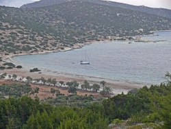
There are two very attractive anchorages in Alimniá.
 The more protected South Cove |
 The East Cove & its ruins |
South Cove
East Cove
Offshore Islands
None.
Yacht Services and Repairs
Marine Stores
None.
Fuel, Water, & Electricity
- Fuel
- N/A (Not Available)
- Water
- N/A
- Electricity
- N/A
Things to do Ashore
Tourism
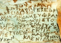 WWII Cartoon |
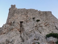 The Castle |
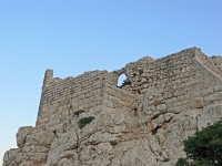 The Castle, again |
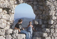 In the Castle |
 Flotsam in the Beach (East Cove) |
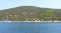
In the South Cove there are a number of deserted WW II buildings with cartoon drawn on their walls by a nostalgic German soldier who was stationed at the submarine base.
A good half an hour hike from the East Cove brings you to the ruins of the Crusader Castle from which you can enjoy a good view of Rhodes and Chálki.
Grocery & Supply Stores
N/A.
Eateries
N/A.
Internet/WiFi
N/A.
Laundry
N/A.
Motorbike & Car Rentals
N/A.
Garbage Disposal
N/A.
Transportation
N/A.
Routes/Passages To/From
Cruiser's Friends
Contact details of "Cruiser's Friends" that can be contacted for local information or assistance.
Forum Discussions
List links to discussion threads on partnering forums. (see link for requirements)
External Links
Links to relevant websites.
- Alimnia at the Wikipedia
References & Publications
See Greece.
Personal Notes
Personal experiences?
Last Visited & Details Checked (and updated here)
Date of member's visit to this Port/Stop & this page's details validated:
- August 2009 --Istioploos

 Travels with S/Y Thetis
| This page has an outline in place but needs completing. Please contribute if you can to help it grow further. Click on Comments to suggest further content or alternatively, if you feel confident to edit this page, click on the edit tab at the top and enter your changes directly. |
| |
|---|
|
Names: Istioploos |
