Antofagasta
From CruisersWiki
Antofagasta, Chile
| | |
| | 23°38.5′S, 070°24.0′W |
|---|---|
| | Photo gallery |
| | Local chartlet |
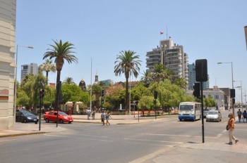
 The Plaza, Antofagasta - click for larger view The Plaza, Antofagasta - click for larger view
| |
Antofagasta is one of the old 'Nitrate Ports' situated in territory aquired by Chile during the 1879-1883 'War of the Pacific'. Up until the 1940's it was a major exporter of nitrates, now its wealth comes from the extensive copper mines in the hinterland. With a population of over 300,000 it has the highest GDP of any area in Chile.
Local Weather
Situated on the edge of the Atacama Desert Antofagasta is in one of the driest regions on earth. It is said to rain on only one day of the year. The prevailing wind is from the south and this keeps the temperature between 5 and 27 degrees throughout the year.
- Forecast sources:
Charts
Please provide a good map or chart that clearly shows details (depths, where to dock, scale etc.) of the harbor.
Give charts applicable to this port or refer to a Chart section of another page (Country or Region) that lists the charts.
- Source
- Chart Number - Chart Name
- Chart Number - Chart Name
- Source
- Chart Number - Chart Name
Radio Nets
The Patagonian Net on 8164 USB may , at times, be heard from Antofagasta.
Also see World Cruiser's Nets.
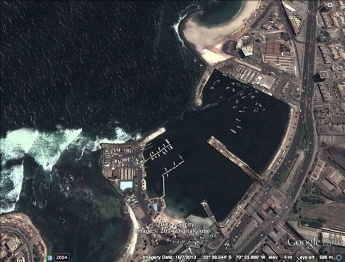
While the approach is straightforward yachts should keep well offshore until abeam the entrance as there are unmarked dangers inshore and the sea can break unexpectedly. Locals suggest keeping the south west face of the Muelle de Salitre just slightly open on the approach. A rock known as 'The Widow' with less than 2 metres over it is situated in the middle of the entrance and when entering it pays to keep close up to the southern breakwater.
The South America Pilot Vol 3 states "During 'Bravezas' and bad weather the channel to Caleta Poza del Saltire is sometimes impassable due to the heavy swell which rolls over the reefs and breaks completely across the entrance. Strangers should on no account attempt to enter the cove at night. Bad weather is said to occur maybe once a year in late winter.
Check-in facilities (for Customs and Immigration)
One hours notice of arrival should be given to 'Antofagasta Port Radio' , VHF Ch 16 and 14, and they should be contacted again once you have berthed.
If entering from another Chilean port then the Armada can be found at Grecia 1946, about a 20 minute walk south of the marina.
If entering from overseas... a very rare event here.. then you should wait for the Armada and Immigration to come to your yacht. Once that has been done you can go to the Aduana office on the left hand side of the entrance to the commercial port ( almost opposite the Capitania) and request an 'Admission Temporal' for your yacht.
Marinas & Yacht Clubs
Club de Yates Antofagasta has two pontoons on the starboard hand as you enter... there is also a visitors' mooring midway between these pontoons and the old Nitrate Pier. Call the Club on Ch 16 for assistance in berthing. Typically it is headlines to the pontoon and a line to a club buoy aft.
Depths alongside the pontoons is variable and caution should be exercised when entering.
There is a hard stand and an 18 tonne Travelift.
Rates in early 2014 were US$20 a day with the first three days free. The price for longer stays is negotiable.
Anchorages
If the port is closed then safe anchorage can be found in the SW corner of Bahia Mejillones, about a daysail north, or , somewhat closer in Caleta Constitucion, 23*26'S, 70*23'W.
There is no safe anchorage outside the port.
Yacht Chandlers, Repairs and Services
There are no dedicated yacht chandlers or repair businesses in the town. However in a town of this size there would be a good chance of getting things fixed as it serves a large mining industry.
Fuel, Water, & Electricity
- Fuel
- Available from the Shell service station about 5 minutes walk south of the marina.
- Water
- Potable water laid on to the pontoons. However as it is produced by a local de-sal plant locals suggest using bottled water for tea and coffee etc.
- Electricity
- 240V laid on to the pontoons at no charge.
Things to do Ashore
Tourism
List places of interest, tours, etc.
Grocery & Supply Stores
Eateries
Internet/WiFi
Free yacht club wi-fi. A number of internet cafes in the town.
Laundry
Motorbike & Car Rentals
Garbage Disposal
?
Transportation
List transportation (local and/or international.)
Routes/Passages To/From
List popular passages/routes, timing, etc.
Cruiser's Friends
Contact details of "Cruiser's Friends" that can be contacted for local information or assistance.
Forum Discussions
List links to discussion threads on partnering forums. (see link for requirements)
External Links
References & Publications
See [Chile#References_.26_Publications|Chile].
Personal Notes
Personal Notes
Personal experiences?
Last Visited & Details Checked (and updated here)
Date of member's visit to this Port/Stop & this page's details validated:
- last visit February 2014.
|
|---|
|
Names: Frank Holden, Westerly Serenade. |
| |
|---|
| | HOMEPAGE | Wiki Contents | South America | East Pacific | South Atlantic | Chile | Antofagasta | |
