California
From CruisersWiki
California Cruising Guide
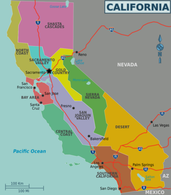
California adjoins the Pacific Ocean, Oregon, Nevada, Arizona, and the Mexican state of Baja California. With an area of 160,000 square miles (414,000 km2), it is the third-largest state in the United States in size, after Alaska and Texas. If it were a country, California would be the 59th-largest in the world in area. Along the California coast are several major metropolitan areas, including Greater Los Angeles, the San Francisco Bay Area, and San Diego.
As part of the Ring of Fire, California is subject to tsunamis, floods, droughts, Santa Ana winds, wildfires, landslides on steep terrain, and has several volcanoes. It sees numerous earthquakes due to several faults, in particular the San Andreas Fault.
Submit details about the sailing/cruising in the area, etc.
Charts
Submit the chart details that are required for safe navigation.
- Chart Source
- Chart No
- Chart No
Radio Nets
Also see World Cruiser's Nets
Local Weather
Much of the state has a Mediterranean climate, with cool, rainy winters and dry summers. The cool California Current offshore often creates summer fog near the coast.
Sources for Weather forecasts:
Special State Boating Bylaws or Restrictions
?
Ports and Popular Stops
- Crescent City
- Fort Bragg
- Los Angeles, CA (Long Beach) (Has data)
- Monterey, CA (Has data)
- San Diego, CA (Has data)
- San Francisco, CA (Has Data)
- Santa Cruz, CA
Offshore Islands and Groups
List Islands
Coastal Passage Notes
Describe coastal passage...
Coastal Anchorages (or "Bolt-Holes")
- Wreck Beach can provide shelter during NW gales while transiting the coast. 6.6nm SE Point Sur, 0.42nm E of Pfeiffer Rock, 42nm NNE Point Piedras Blancas. The the area of
 36°13.97′N, 121°48.12′W there are sandy patches devoid of kelp in which a vessel can anchor in 10-20m. Fishing vessels frequently use this anchorage. Unusable in W or S weather.
- San Simeon provides good anchorage during the prevailing NW weather or in settled conditions. 5nm ESE Point Piedras Blancas. 24nm NNE Morro Bay. 76nm SSE Monterey at
 35°38.43′N, 121°11.44′W. A small S facing bight protected by a point and a reef. The reef extends S to the buoy which should be sighted before attempting entry from either N or S. Anchor off the beach W of the pier in 5-10m. San Simeon may be safer to enter in NW gales than crossing the bar at nearby Morro Bay. There are reportedly some restaurants and groceries ashore. Hearst Castle, a popular tourist attraction, is here.
- Cojo Anchorage provides good anchorage and shelter during the NW gales that can prevent a transit of nearby Point Conception. 1nm NE of Point Conception, 30nm W of Santa Barbara, 34nm NW of Santa Cruz Island, and 65nm SSE of Morro Bay. Anchorage may be taken directly off the prominent culvert under the railroad track that runs just behind the beach in the vicinity of
 34°26.97′N, 120°26.58′W. Often moored nearby is Mr. Clean, an oil spill cleanup vessel. The land ashore in this area is either private or part of the Vandenburg Air Force Base. There is no highway access here. There is often exceptional surfing in the area running several miles E of here.
Cruiser's Friends
Contact details of "Cruiser's Friends" that can be contacted for local information or assistance.
Forum Discussions
List links to discussion threads on partnering forums. (see link for requirements)
External Links
Links to relevant websites.
References & Publications
Publications, Guides, etc.
Personal Notes
Personal experiences?
Last Visited & Details Checked (and updated here)
Date of member's visit to this Port/Stop & this page's details validated:
|
|---|
|
Names: |
| |
|---|
| | HOMEPAGE | Wiki Contents | United States | California | |
