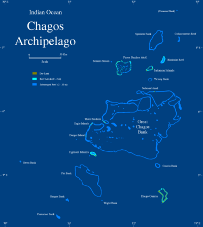
Chagos Archipelago
From CruisersWiki
Lighthouse (Talk | contribs) (→Islands & Popular Stops) |
Lighthouse (Talk | contribs) |
||
| Line 42: | Line 42: | ||
===Islands & Popular Stops=== | ===Islands & Popular Stops=== | ||
| - | + | * '''Salomon Islands''' - (5º22’S., 72º13’E.) lie on an atoll reef, which encloses a lagoon. | |
| - | * '''Salomon Islands''' - (5º22’S., 72º13’E.) lie on an atoll reef, which encloses a lagoon. The entrance to the lagoon is through a passage on the NW side of the atoll. A least depth of 5.8m (19ft.) may be carried through it, but the bar is impassable during the NW monsoon.<br/><br/>The C-Map chart is reported to be inaccurate. The following waypoints for the entrance are reportedly excellent with the minimum depth of 7m. You will see the reef to port around Ile de la Passe.<br/>1. 05º 18' 00 S 72º 14' 40 E<br/>2. 05º 18' 85 S 72º 14' 81 E<br/><br/>There is a sand patch to starboard inside the entrance where some yachts anchor if there is poor light to traverse the atoll. If visibility is good, make your way over to ''Ile Anglais'' keeping a close watch for coral heads. Anchored near 05º 19' 23 S 072º 13' 82 E in 10m coral/sand, flat bottom. | + | |
| + | <center><gallery caption="Salomon (Click for larger views)" widths="160px" heights="120px" perrow="4"> | ||
| + | Image:Salomonmap.PNG|Salomon | ||
| + | Image:Saloman_Photo_Rick_Miller.jpg|Salomon ''Photo - Rick Miller | ||
| + | Image:Chagos_Salomon.jpg|Comment | ||
| + | </gallery></center> | ||
| + | |||
| + | The entrance to the lagoon is through a passage on the NW side of the atoll. A least depth of 5.8m (19ft.) may be carried through it, but the bar is impassable during the NW monsoon.<br/><br/>The C-Map chart is reported to be inaccurate. The following waypoints for the entrance are reportedly excellent with the minimum depth of 7m. You will see the reef to port around Ile de la Passe.<br/>1. 05º 18' 00 S 72º 14' 40 E<br/>2. 05º 18' 85 S 72º 14' 81 E<br/><br/>There is a sand patch to starboard inside the entrance where some yachts anchor if there is poor light to traverse the atoll. If visibility is good, make your way over to ''Ile Anglais'' keeping a close watch for coral heads. Anchored near 05º 19' 23 S 072º 13' 82 E in 10m coral/sand, flat bottom. | ||
* '''Peros Banhos''' - (5°15'S., 71°46'E.) | * '''Peros Banhos''' - (5°15'S., 71°46'E.) | ||
* '''Diego Garcia''' - (7º21’S., 72º28’E.) is an American Communication base, and is '''off limits''' to visitors, except possibly in a dire emergency. | * '''Diego Garcia''' - (7º21’S., 72º28’E.) is an American Communication base, and is '''off limits''' to visitors, except possibly in a dire emergency. | ||
Revision as of 10:59, 22 September 2008
CHAGOS (BIOT) CRUISING GUIDE
Background
The Chagos Archipelago consists of a number of islands, banks, and reefs lying between the parallels of 4º44’S and 7º39’S, and the meridians of 70º50’E and 72º47’E.
Caution – It is said that the deeper parts of the banks within the Chagos Archipelago may be crossed when there is not much swell. However, the uncertainty regarding the depths over areas that have been only partially examined, the changeable character of coral reefs, and the unexpected manner in which the sea sometimes breaks, all emphasize the advisability of avoiding the banks. Moreover, it is possible to proceed from island to island without crossing over any of the banks.
Climate & Weather
See: Weather, Winds and Currents on the Indian Ocean page
Submit the sources of weather forecasting here.
Charts
Submit details of the charts required for safe navigation of the area.
Local Radio Nets
Also see World Cruiser's Nets
- South Africa Maritime Mobile Net - See Cruiser's Nets for details
- Radio Peri-Peri - See Cruiser's Nets for details
- Maritime Mobile Net South East Asia (MMNETSEA) - See Cruiser's Nets for details
Arrival/Departure procedures
Submit any details about advance notification of arrival, etc.
N.B. As of Dec. 06, a permit must be obtained PRIOR to a visit to Chagos. For further details see: Chagos Permits
Immigration
Submit details about immigration procedures here.
Customs
Details?
Health & Security
Submit any health warnings/information and any security details here.
Islands & Popular Stops
- Salomon Islands - (5º22’S., 72º13’E.) lie on an atoll reef, which encloses a lagoon.
Salomonmap.PNG
Salomon |
The entrance to the lagoon is through a passage on the NW side of the atoll. A least depth of 5.8m (19ft.) may be carried through it, but the bar is impassable during the NW monsoon.
The C-Map chart is reported to be inaccurate. The following waypoints for the entrance are reportedly excellent with the minimum depth of 7m. You will see the reef to port around Ile de la Passe.
1. 05º 18' 00 S 72º 14' 40 E
2. 05º 18' 85 S 72º 14' 81 E
There is a sand patch to starboard inside the entrance where some yachts anchor if there is poor light to traverse the atoll. If visibility is good, make your way over to Ile Anglais keeping a close watch for coral heads. Anchored near 05º 19' 23 S 072º 13' 82 E in 10m coral/sand, flat bottom.
- Peros Banhos - (5°15'S., 71°46'E.)
- Diego Garcia - (7º21’S., 72º28’E.) is an American Communication base, and is off limits to visitors, except possibly in a dire emergency.
Cruiser's Friends
Submit details/contacts of cruiser's "friends" that can be contacted in advance or on arrival - who can offer information and assistance to our cruising "family".
References & Publications
- Indian Ocean Crossing Notes by Tony Herrick
Links to CruiserLog Forum discussions
Links to discussions on the CruiserLog Forum
External Links
Personal Notes
Personal experience
| |
|---|
| | HOMEPAGE | WIKI CONTENTS | Indian Ocean | Chagos | |
.


