Indian Ocean
From CruisersWiki
| Indian Ocean
|

Cruising and sailing in the Indian Ocean is a wonderful experience with all those beautiful Indian Ocean islands and atolls, many of which are remote and seldom visited.
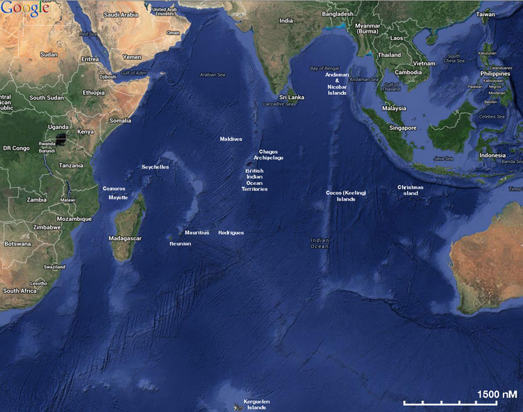
The Indian Ocean is the third largest of the world's oceanic divisions, covering about 20% of the water on the Earth's surface. It is bounded on the north by Asia (including the Indian subcontinent, after which it is named); on the west by Africa; on the east by Indochina, the Sunda Islands, and Australia; and on the south by the Southern Ocean (or, traditionally, by Antarctica). One component of the all-encompassing World Ocean, the Indian Ocean is delineated from the Atlantic Ocean by the 20° east meridian running south from Cape Agulhas, and from the Pacific by the 147° east meridian. The northernmost extent of the Indian Ocean is approximately 30° north in the Persian Gulf and, thus, has asymmetric ocean circulation. This ocean is nearly 10,000 kilometres (6,200 mi) wide at the southern tips of Africa and Australia; its area is 73,556,000 square kilometres (32.1 mi), including the Red Sea and the Persian Gulf. The ocean's volume is estimated to be 292,131,000 cubic kilometers (70,086,000 mi³). Small islands dot the continental rims. Island nations within the ocean are Madagascar (formerly Malagasy Republic), the world's fourth largest island; Comoros; Seychelles; Maldives; Mauritius; and Sri Lanka. Indonesia borders it on the east. The ocean's importance as a transit route between Asia and Africa has made it a scene of conflict. Because of its size, however, no nation had successfully dominated most of it until the early 1800s when the United Kingdom controlled much of the surrounding land. After the decline of the British Empire, the ocean has since been dominated by India and Australia.
Charts
- British Admiralty
- BA4070 – Indian Ocean southern part Scale 1: 10 000 000
- BA4071 – Indian Ocean northern part Scale 1 : 10 000 000
- BA4072 – Indian Ocean western part Scale 1 : 10 000 000
- BA4073 – Indian Ocean eastern part Scale 1 : 10 000 000
- BA4700 – Port Elizabeth to Mauritius Scale - 1 : 3 500 000
- BA4701 – Maputo to Moqudisho - 1 : 3 500 000
- BA4702 – Chagos to Madagascar - 1 : 3 500 000
- BA4701 – Gulf of Aden to Seychelles and Maldives - 1 : 3 500 000
- BA4706 – Bay of Bengal - 1 : 3 500 000
- BA4707 – Maldives to Sumatra - 1 : 3 500 000
- BA4708 – Australia west coast - 1 : 3 500 000
- BA4709 – Australia south coast - 1 : 3 500 000
- BA4710 – Cape Leeuwin to south east Indian ridge - 1 : 3 500 000
- BA4711 – Ile Amsterdam to Ile Kerguelen - 1 : 3 500 000
- BA4713 – Ile de Reunion to Ile St Paul - 1 : 3 500 000
- BA4714 – Cocos Keeling to Ile St Paul - 1 : 3 500 000
- BA648 – Maputo to Pont de Bartolomeu Diaz - 1 : 1 000 000
- BA3300 – Mbashe Point to Maputo - 1 : 1 000 000
- BA1810 – Mozambique Channel - 1 : 1 000 000
- BA3877 – Mozambique Channel northern part - 1 : 1 076 000
Weather
Northern Indian Ocean
The Indian Ocean area is generally dominated by the NE and SW monsoons, which refers to the directions of the prevailing winds.
The NE monsoon is the cooler season and is mostly dry, whereas the SW monsoon is known as the rainy season, often with torrential rain and hot, humid conditions.
The SW Monsoon blows during the northern summer, from about May to September/October. The influence of this stretches across the northern Indian Ocean, from the Gulf of Aden to the Andaman Sea, often with force 7 - 8 winds, for days on end. This wind direction can be used to ones advantage, in a passage from the Maldives or Sri Lanka to Thailand or Malaysia.
The Northeast Monsoon blows during the northern winter from about November to March. The NE monsoon blows with less consistency than its opponent wind and covers the same area, and is generally of lighter force, 4 - 5 being the norm. Early in the year is the recommended time for making a westerly passage across the northern Indian Ocean. The ocean currents mostly follow the direction of the prevailing monsoons and are mostly in the ½ to 1 knot range. In the northern winter the equatorial current is almost non-existent.
Southern Indian Ocean
The southern Indian Ocean, from around 4ºS to 25ºS, is dominated all year round by the SE Trade Winds. In the Mozambique Channel the wind direction can change and is often higher than the average force 4 – 5 of the SE Trades. The recommended time to use these trades to your advantage is between mid April and mid November. South of the Equator there is a W to SW current, the South Equatorial Current, of around ½ to 1 knot.
Southern Ocean, to 40ºS, winds and current are discussed in Australia to South Africa.
Sources for weather information:
- East Indian Ocean
- The High Seas (METAREA) forecast for the Eastern Indian Ocean is published by the Australian Bureau of Meteorology. It is broadcast on HF/SSB frequencies by Australian Weather West (VMW) on a regular automated schedule. See their relevant website page for schedule and frequencies.
- West Indian Ocean
- The South Africa Maritime Mobile Net relays weather information for this area - see Cruiser's Nets for details.
- Cruising Connections Weather Comprehensive weather links for SE Indian Ocean.
Tropical Storms And Cyclones
Tropical Storms and Cyclones generally breed in the vicinity of 7º of their respective hemispheres and tend to track NW in the Northern Hemisphere and SW in the Southern Hemisphere. The most destructive areas tend to be between 10º and 15º, however this is not always the case.
A Cyclone normally “dies” out when it is over a major landmass, the exception seems to be Northern Madagascar, in the limits of these notes. Often a Cyclone will dissipate over Northern Madagascar, only to intensify over the Mozambique Channel.
The SW Indian Ocean has the most Tropical Storms or Cyclones in the Indian Ocean – the average from weather charts appears to be 8 Tropical Storms and 4 Cyclones per year.
The Cyclone season is from mid November to April, with December to March generally the worst months. However, Cyclones have been known outside the “season”.
Arabian Sea And Bay Of Bengal
The SW Monsoon period extends from May to September, and the Cyclone season is from May to December. Northern Australia’s Cyclone season is the same as the south Indian Ocean.
The Intertropical Convergance Zone, or ITZC or the Doldrums, is usually situated around the Equator or just south of it for most of the year. Often, in the “Belt”, one will sometimes experience days of tropical thunderstorms with dramatic lightning displays.
Excerpts from Indian Ocean Crossing Notes - by Tony Herrick
Currents & Tides

Passages
- Australia to South Africa
- South Africa to Australia
- South East Asia to Red Sea
- Red Sea to South East Asia
- South East Asia to South Africa
Also see the Mozambique Channel.
Communication


Also see World Cruiser's Nets
- THE IO NET - Malaysia, Thailand, N.Indian Ocean to Red Sea 0030UTC on 8188USB - See Cruiser's Nets for details
- South Africa Maritime Mobile Net - See Cruiser's Nets for details.
- Radio Peri-Peri - See Cruiser's Nets for details (Now "Silent Key"). Now operated by "Roy".
- Maritime Mobile Net South East Asia (MMNETSEA) - See Cruiser's Nets for details
Any navigation notes here. If this section does not apply remove it.
Health & Security
Piracy is a major problem in the waters of Somalia and India.
Countries, Ports, Anchorages, and Islands
Counterclockwise from N to SW, SE, and NE.
![]() = Featured Cruising Guides,
= Featured Cruising Guides, ![]() = Port of Entry,
= Port of Entry, ![]() = Island,
= Island, ![]() = Marina,
= Marina, ![]() = Harbor,
= Harbor, ![]() = Anchorage,
= Anchorage, ![]() = Needs data.
= Needs data.
| Countries | Islands Countries & Islands | Ports & Anchorages |
|
Friends
Contact details of "Cruiser's Friends" that can be contacted for local information or assistance.
Forums
List links to discussion threads on partnering forums. (see link for requirements).
- Crossing the Indian Ocean - East to West (on CruiserLog)
- Yachts heading to South Africa (on CruiserLog)
- Indian Ocean Sailing and Cruising Discussions on Cruisers Forum
Links
- Indian Ocean at the Wikipedia
- Cruising Connections - Durban. New & Used Charts, Cruising Guides, Pilots, flags, etc.
References and Publications
- Southern Indian Ocean Crossing Notes (East to West & W - E) by Tony Herrick
-
{{Reference|Rod Heikel|Greek Waters Pilot Imray||Laurie and Wilson, Cambridgeshire|9780852889718}}, expands to - Rod Heikell, Greek Waters Pilot Imray, Laurie and Wilson, Cambridgeshire, ISBN 9780852889718
- Author, Title, Publisher, ISBN ISBN number
- Author, Title, Publisher, ISBN ISBN number
You may want to remove the above entries and use instead a link to the Country or Region that lists the relevant references. If so enter, after removing {{MagentaText|xx}}, the following:
See [[Country or Region#References_&_Publications|Coutry or Region]].
If you do not use the above link, please remove it.
Also See
Comments
We welcome users' contributions to the Wiki. Please click on Comments to view other users' comments, add your own personal experiences or recommend any changes to this page following your visit.
| This is a usable page of the cruising guide. However, please contribute if you can to help it grow further. Click on Comments to add your personal notes on this page or to discuss its contents. Alternatively, if you feel confident to edit the page, click on the edit tab at the top and enter your changes directly. |
| |
|---|
|
Names: Lighthouse, Zbyszek, TaoJones, Haiqu, Timovaan, Istioploos |