Chios
From CruisersWiki
Istioploos (Talk | contribs) m (→Last Visited & Details Checked (and updated here): Navigation Bar) |
Istioploos (Talk | contribs) (Coords & minor edits) |
||
| Line 1: | Line 1: | ||
==Chios (Port of Entry)== | ==Chios (Port of Entry)== | ||
| - | [[Image: | + | GPS: {{Coord|38|22.2|N|26|08.7|E|}} |
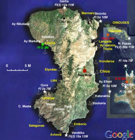
| + | [[Image:Greece_Chios_S.jpg|450px|thumb|center|Satellite View of Chios & Oinouses<br/>''Click for larger view'' ]] | ||
===Background=== | ===Background=== | ||
| Line 35: | Line 36: | ||
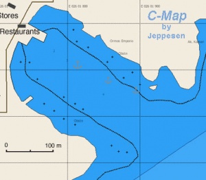
====Chios Harbor (Port of Entry)==== | ====Chios Harbor (Port of Entry)==== | ||
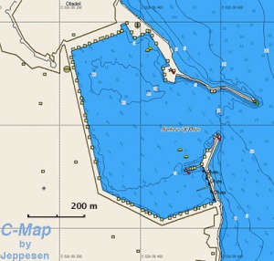
| - | [[Image: | + | [[Image:Greece_Chios_h.jpg|300px|thumb|right|Chart of Chios Harbor - [http://mapserver.maptech.com/homepage/index.cfm?lat=38.370375529736855&lon=26.142832383720798&scale=12500&zoom=50&type=0&icon=0&width=498&height=498&searchscope=dom&CFID=1509264&CFTOKEN=22608242&scriptfile=http://mapserver.maptech.com/homepage/index.cfm&latlontype=DMS Chartlet]<br/>''Click for larger view'' ]] |
| + | GPS: {{Coord|38|22.2|N|26|08.7|E|}}<br/> | ||
This is a large and bustling harbor of a very vibrant town.<br/> | This is a large and bustling harbor of a very vibrant town.<br/> | ||
<br/><br/><br/><br/><br/><br/> | <br/><br/><br/><br/><br/><br/> | ||
| Line 43: | Line 45: | ||
====Limniá==== | ====Limniá==== | ||
{| | {| | ||
| - | |valign="top"|Limniá (Λιμνιά) located on NW side of the island | + | |valign="top"|GPS: {{Coord|38|28.1|N|25|55.1|E|}}<br/> |
| + | Limniá (Λιμνιά) located on NW side of the island is the harbor of [[#Volissós|Volissós]] (Βολισσός) a picturesque town about 4 km up the hill from the harbor. It is a safe harbor providing all-weather shelter. Go stern-to on the new quay NE of the old dock used by local fishermen. | ||
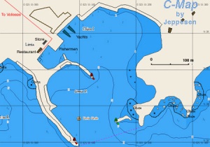
There are water outlets on the quay also there are two inoperative water/electricity posts (2006). The nearest fuel station is outside of Volissós but they will deliver except on Sundays. Call VHF channel 21. Just SW of the fishing dock there is the friendly restaurant ''Ta Limnia'' (tel. +30 22710 21 014) which not only provides good food but the owner, Mr. Tsikalas, can assist you with getting fuel or renting a car. | There are water outlets on the quay also there are two inoperative water/electricity posts (2006). The nearest fuel station is outside of Volissós but they will deliver except on Sundays. Call VHF channel 21. Just SW of the fishing dock there is the friendly restaurant ''Ta Limnia'' (tel. +30 22710 21 014) which not only provides good food but the owner, Mr. Tsikalas, can assist you with getting fuel or renting a car. | ||
| Line 55: | Line 58: | ||
* June 2006 --[[User:Istioploos|Istioploos]] 08:37, 6 June 2008 (MDT) | * June 2006 --[[User:Istioploos|Istioploos]] 08:37, 6 June 2008 (MDT) | ||
* | * | ||
| + | |||
| + | |valign="top"|[[Image:Greece_Chios_Limnia_h.jpg|300px|thumb|right|Chart of Limniá Harbor - [http://mapserver.maptech.com/homepage/index.cfm?lat=38.46963497792535&lon=25.92003954737269&scale=10000&zoom=50&type=0&icon=0&width=498&height=498&searchscope=dom&CFID=1509264&CFTOKEN=22608242&scriptfile=http://mapserver.maptech.com/homepage/index.cfm&latlontype=DMS Chartlet]<br/>''Click for larger view'' ]] | ||
| + | |} | ||
[[Image:Chios_Limn.jpg|200px|thumb|center|Limniá Harbor<br/>''Click for larger view'' ]] | [[Image:Chios_Limn.jpg|200px|thumb|center|Limniá Harbor<br/>''Click for larger view'' ]] | ||
| - | |||
| - | |||
| - | |||
==== Marmaro==== | ==== Marmaro==== | ||
{| | {| | ||
| - | |valign="top"|Marmaro (Μάρμαρο- marble) or Kardamyla is located on the E of N coast of Chios. It is small man-made harbor which while being protected from the ''meltemi'' allows uncomfortable swell to enter from the N and spray on jetty. Moor alongside on the S side of jetty. Fuel can be obtained from a BP station (tel. +30 22710 23 565 or 22 955) located approximately 1 km uphill from harbor. They sometimes deliver. A second ''BP'' is another km further up the road from the first. Marmaro is not a particularly interesting place but there are some nice beaches nearby. | + | |valign="top"|GPS: {{Coord|38|32.7|N|26|06.7|E|}} |
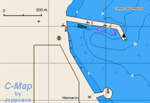
| + | Marmaro (Μάρμαρο- marble) or Kardamyla is located on the E of N coast of Chios. It is small man-made harbor which while being protected from the ''meltemi'' allows uncomfortable swell to enter from the N and spray on jetty. Moor alongside on the S side of jetty. Fuel can be obtained from a BP station (tel. +30 22710 23 565 or 22 955) located approximately 1 km uphill from harbor. They sometimes deliver. A second ''BP'' is another km further up the road from the first. Marmaro is not a particularly interesting place but there are some nice beaches nearby. | ||
=====Last Visited & Details Checked (and updated here)===== | =====Last Visited & Details Checked (and updated here)===== | ||
| Line 70: | Line 74: | ||
* | * | ||
| - | |[[Image: | + | |[[Image:Greece_Chios_Marmaro_h.jpg|300px|thumb|right|Chart of Marmaro Harbor - [http://mapserver.maptech.com/homepage/index.cfm?lat=38.55923173614256&lon=26.113716079885005&scale=150000&zoom=100&type=0&icon=0&width=498&height=498&searchscope=dom&CFID=1509264&CFTOKEN=22608242&scriptfile=http://mapserver.maptech.com/homepage/index.cfm&latlontype=DMS Chartlet]<br/>''Click for larger view'' ]] |
|} | |} | ||
==== Limenas==== | ==== Limenas==== | ||
{| | {| | ||
| - | |valign="top"|The harbor of [[#Mestá|Mestá]] (Μεστά) or Limenas (Λιμένας) | + | |valign="top"|GPS: {{Coord|38|17.3|N|25|55.8|E|}} |
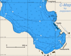
| + | The harbor of [[#Mestá|Mestá]] (Μεστά) or Limenas (Λιμένας) is on the S side of the W coast of Chios. While there is protection from the ''meltemi'' behind the mole, the swell can be uncomfortable. Excellent protection from the southerlies.There is plenty of docking space. Come side-to, there is at least 3 m depth. Be aware of the large car tires on the quay, they leave hard to remove black marks on the hull and fenders. There are some ugly buildings near the dock, two restaurants but no provisions. The bay looks attractive. Short (about 4 km) distance to the picturesque town of Mesta. There are regular buses to Chios. The ''Limenarchio'' (Coast Guard) here always comes to ask for the harbor dues. | ||
There is a taxi in Mesta, tel +30 6972 543 543 and one in Olympoi, tel. +30 2710 76 357 or +30 6937 937 758. Also in Pyrgi Konstantinos Tomazos (+30 22710 722 190) rents scooters. | There is a taxi in Mesta, tel +30 6972 543 543 and one in Olympoi, tel. +30 2710 76 357 or +30 6937 937 758. Also in Pyrgi Konstantinos Tomazos (+30 22710 722 190) rents scooters. | ||
| Line 84: | Line 89: | ||
* | * | ||
| - | |[[Image: | + | |[[Image:Greece_Chios_Limenas_h.jpg|300px|thumb|right|Chart of Limenas Harbor - [http://mapserver.maptech.com/homepage/index.cfm?lat=38.30771742560356&lon=25.928545572377477&scale=150000&zoom=100&type=0&icon=0&width=498&height=498&searchscope=dom&CFID=1509264&CFTOKEN=22608242&scriptfile=http://mapserver.maptech.com/homepage/index.cfm&latlontype=DMS Chartlet]<br/>''Click for larger view'' ]] |
|} | |} | ||
====Líthi==== | ====Líthi==== | ||
| - | + | {| | |
| - | Líthi (Λίθι) | + | |valign="top"|GPS: {{Coord|38|20.5|N|25|59.5|E|}} |
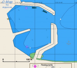
| + | Líthi (Λίθι) has a small harbor which provides good shelter from the ''meltemi''. Dock side-to on the mole. There is room for 2-3 yachts. Alternatively you can anchor off in 5-6 m, good holding in sand but you are more exposed to the N wind. | ||
There are 3 tavernas ashore of which ''Kyra Despina'' and the ''3 Adelphia'' have good fish. | There are 3 tavernas ashore of which ''Kyra Despina'' and the ''3 Adelphia'' have good fish. | ||
| Line 100: | Line 106: | ||
[[Image:Chios_Lithi.jpg|200px|thumb|center|The Harbor of Líthi<br/>''Click for larger view'' ]] | [[Image:Chios_Lithi.jpg|200px|thumb|center|The Harbor of Líthi<br/>''Click for larger view'' ]] | ||
| + | |valign="top"|[[Image:Greece_Chios_Lithi_h.jpg|300px|thumb|right|Chart of Líthi Harbor<br/>''Click for larger view'' ]] | ||
| + | |} | ||
===Marinas & Yacht Clubs=== | ===Marinas & Yacht Clubs=== | ||
* [[Chios Marina]] | * [[Chios Marina]] | ||
| Line 105: | Line 113: | ||
===Anchorages=== | ===Anchorages=== | ||
====Vrondaros==== | ====Vrondaros==== | ||
| + | GPS: {{Coord|38|25.2|N|26|08.1|E|}}<br/> | ||
This is a very small harbor N of the town of Chios. It provides good shelter but room is very limited. | This is a very small harbor N of the town of Chios. It provides good shelter but room is very limited. | ||
====Emborio==== | ====Emborio==== | ||
{| | {| | ||
| - | |valign="top"|Emborio (Εμπορειό- commerce) is lovely little natural on the SE coast of Chios. It provides good shelter from the meltemi but because it is so small it good be difficult to find where to anchor. Good holding. There are a couple of tavernas ashore, telephone, and a small store with limited supplies. On the NE of the cove, and up the hill there is a [http://en.wikipedia.org/wiki/Bronze_Age Bronze Age] (3rd millennium BC) excavation but there is not too much to see. If you continue along this road you come to Mavra Volia, a beautiful black pebble beach, totally deserted. | + | |valign="top"|GPS: {{Coord|38|11.2|N|26|01.9|E|}} |
| + | Emborio (Εμπορειό- commerce) is lovely little natural on the SE coast of Chios. It provides good shelter from the meltemi but because it is so small it good be difficult to find where to anchor. Good holding. There are a couple of tavernas ashore, telephone, and a small store with limited supplies. On the NE of the cove, and up the hill there is a [http://en.wikipedia.org/wiki/Bronze_Age Bronze Age] (3rd millennium BC) excavation but there is not too much to see. If you continue along this road you come to Mavra Volia, a beautiful black pebble beach, totally deserted. | ||
| Line 119: | Line 129: | ||
[[Image:Chios_Volia.jpg|200px|thumb|center|Mavra Volia<br/>''Click for larger view'' ]] | [[Image:Chios_Volia.jpg|200px|thumb|center|Mavra Volia<br/>''Click for larger view'' ]] | ||
| - | |[[Image: | + | |valign="top"|[[Image:Greece_Chios_Emborio_h.jpg|300px|thumb|right|Chart of Emborio - [http://mapserver.maptech.com/homepage/index.cfm?lat=38.179661343942925&lon=26.03226942341724&scale=150000&zoom=100&type=0&icon=0&width=498&height=498&searchscope=dom&CFID=1509264&CFTOKEN=22608242&scriptfile=http://mapserver.maptech.com/homepage/index.cfm&latlontype=DMS Chartlet]<br/>''Click for larger view'' ]] |
|} | |} | ||
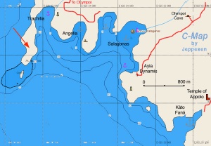
====Angelia, Salagonas, Trachilia, and Kato Faná==== | ====Angelia, Salagonas, Trachilia, and Kato Faná==== | ||
| - | [[Image: | + | [[Image:Greece_Chios_Salagonas.jpg|300px|thumb|right|Chart of Salagonas Bay Anchorages - [http://mapserver.maptech.com/homepage/index.cfm?lat=38.203333&lon=25.923333&scale=24000&zoom=50&type=1 Chartlet]<br/>''Click for larger view'' ]] |
West of Cape Masticho and just before reaching Cape Mesta on the S coast of Chios there are 5 wonderful coves. All of them are well protected from the ''meltemi'' but exposed to the SW. | West of Cape Masticho and just before reaching Cape Mesta on the S coast of Chios there are 5 wonderful coves. All of them are well protected from the ''meltemi'' but exposed to the SW. | ||
| - | The easternmost cove is Kato Faná Bay (Κάτω Φανά). There only here some abandoned campers. Nearby there are the ruins of a temple of Apollon and a small church. The road from here leads you to the medieval village of Olýmpoi (Ολύμποι), about 8 km away, a good walk. | + | The easternmost cove is Kato Faná Bay (Κάτω Φανά) (GPS: {{Coord|38|12.2|N|25|55.4|E|}}). There only here some abandoned campers. Nearby there are the ruins of a temple of Apollon and a small church. The road from here leads you to the medieval village of Olýmpoi (Ολύμποι), about 8 km away, a good walk. |
| - | Next going W is the small cove of Ayia Dynamis (Αγία Δύναμις). There are a few buildings associated with a church. The road from here leads you to the medieval village of Olýmpoi, about 8 km away, a good walk. About 1.5 km from Ayia Dynamis there is the cave of Olýmpi, open every day except Mondays, 9:00-19:30 with guided tours, well worth the visit. | + | Next going W is the small cove of Ayia Dynamis (Αγία Δύναμις) (GPS: {{Coord|38|12.9|N|25|54.7|E|}}). There are a few buildings associated with a church. The road from here leads you to the medieval village of Olýmpoi, about 8 km away, a good walk. About 1.5 km from Ayia Dynamis there is the cave of Olýmpi, open every day except Mondays, 9:00-19:30 with guided tours, well worth the visit. |
| - | To the E of a promontory there is the larger Salagonas (Σαλάγωνας) | + | To the E of a promontory there is the larger Salagonas (Σαλάγωνας) (GPS: {{Coord|38|13.2|N|25|54.8|E|}}), totally deserted, save for few people during the day harvesting the ''mastich''. |
| - | Next, to the W of the promontory is Angelia (Αγγέλια) with a small hamlet. | + | Next, to the W of the promontory is Angelia (Αγγέλια) (GPS: {{Coord|38|13.2|N|25|54|E|}}) with a small hamlet. |
| - | Finally the westernmost cove is the narrow inlet of Trachilia (Τραχείλια), totally deserted. Anchoring is easy in all of these cove. In Trachilia it is best to take a shore line to the W shore. | + | Finally the westernmost cove is the narrow inlet of Trachilia (Τραχείλια) (GPS: {{Coord|38|13.2|N|25|53.6|E|}}), totally deserted. Anchoring is easy in all of these cove. In Trachilia it is best to take a shore line to the W shore. |
About one hour walk from here, up the dirt road, there is the medieval village of [[#Olýmpoi|Olýmpoi]], well worth a visit. Turn left when you reach the paved road. The other medieval village, [[#Mestá|Mestá]] is about a two hour walk, turn right when you reach the paved road. | About one hour walk from here, up the dirt road, there is the medieval village of [[#Olýmpoi|Olýmpoi]], well worth a visit. Turn left when you reach the paved road. The other medieval village, [[#Mestá|Mestá]] is about a two hour walk, turn right when you reach the paved road. | ||
| Line 154: | Line 164: | ||
====Elyndas==== | ====Elyndas==== | ||
[[Image:Chios_Elindas.jpg|200px|thumb|right|Elyndas<br/>''Click for larger view'' ]] | [[Image:Chios_Elindas.jpg|200px|thumb|right|Elyndas<br/>''Click for larger view'' ]] | ||
| - | Elyndas (Ελύντας) or Alindas (Αλύντας) is lovely cove on the W coast of Chios | + | GPS: {{Coord|38|23.4|N|25|59.4|E|}}<br/> |
| + | Elyndas (Ελύντας) or Alindas (Αλύντας) is lovely cove on the W coast of Chios. It has a wonderful beach which when I visited it was occupied by a few campers, all local, out for the Sunday. Anchor at 10 m depth, very close to the beach. The cove looks well protected from the NW wind and it could be a good anchorage, although it is not mentioned by the pilot books. The only fault that I can find with this cove is that its water is not crystal clear but somewhat murky and greenish. | ||
=====Last Visited & Details Checked (and updated here)===== | =====Last Visited & Details Checked (and updated here)===== | ||
| Line 162: | Line 173: | ||
====Avloniá==== | ====Avloniá==== | ||
| - | + | GPS: {{Coord|38|09.8|N|25|59.6|E|}}<br/> | |
| + | Avloniá is a small cove about 1 M west of Cape Masticho. It is surrounded by steep cliffs and offers good protection from the ''meltemi''. Anchor in 4 m on sand, good holding. | ||
=====Last Visited & Details Checked (and updated here)===== | =====Last Visited & Details Checked (and updated here)===== | ||
| Line 170: | Line 182: | ||
====Langadas==== | ====Langadas==== | ||
| + | GPS: {{Coord|38|28.7|N|26|07.7|E|}} - [http://mapserver.maptech.com/homepage/index.cfm?lat=38.478333&lon=26.128333&scale=24000&zoom=50&type=1 Chartlet]<br/> | ||
Langadas or Kolokithia is a small picturesque harbor. It is not very good with the ''meltemi''. | Langadas or Kolokithia is a small picturesque harbor. It is not very good with the ''meltemi''. | ||
| Line 178: | Line 191: | ||
====Ayios Ioannis Tholis==== | ====Ayios Ioannis Tholis==== | ||
| + | GPS: {{Coord|38|28|N|26|08.8|E|}} - [http://mapserver.maptech.com/homepage/index.cfm?lat=38.466212139568405&lon=26.14590346832956&scale=15000&zoom=50&type=0&icon=0&width=498&height=498&searchscope=dom&CFID=1509264&CFTOKEN=22608242&scriptfile=http://mapserver.maptech.com/homepage/index.cfm&latlontype=DMS Chartlet]<br/> | ||
Well protected from the ''meltemi'' but it is occupied by a fish farm which pollutes the water and makes this cove unattractive. | Well protected from the ''meltemi'' but it is occupied by a fish farm which pollutes the water and makes this cove unattractive. | ||
| Line 188: | Line 202: | ||
====Oinousses==== | ====Oinousses==== | ||
{| | {| | ||
| - | |valign="top"|While [http://en.wikipedia.org/wiki/Oinoussais Oinoussa], the main island of the Oinousses (Οινούσσες) group, is the birthplace of some of Greece's wealthiest shipowners who have large villas there, it still retains the old village feeling. It is clean, quiet, non commercial, with pure island architecture. | + | |valign="top"|GPS: {{Coord|38|30.8|N|26|13.1|E|}} |
| + | While [http://en.wikipedia.org/wiki/Oinoussais Oinoussa], the main island of the Oinousses (Οινούσσες) group, is the birthplace of some of Greece's wealthiest shipowners who have large villas there, it still retains the old village feeling. It is clean, quiet, non commercial, with pure island architecture. | ||
<center><gallery widths="140px" heights="200px" perrow="2"> | <center><gallery widths="140px" heights="200px" perrow="2"> | ||
| Line 200: | Line 215: | ||
=====Oinoussa===== | =====Oinoussa===== | ||
{| | {| | ||
| - | |valign="top"|The main harbor is Oinoussa or Mandraki (Μανδράκι) | + | |valign="top"|GPS: {{Coord|38|30.8|N|26|13.1|E|}} |
| + | The main harbor is Oinoussa or Mandraki (Μανδράκι). It provides good all-round shelter. You can either moor at the NE quay or anchor offshore. Good holding on mud and weed bottom. | ||
<font color="red">Caution:</font> Always enter the harbor from the W, the water between the little islands is too shallow and full of reefs. | <font color="red">Caution:</font> Always enter the harbor from the W, the water between the little islands is too shallow and full of reefs. | ||
| Line 206: | Line 222: | ||
The town of Oinoussa is a short walk uphill from the harbor with many old houses and magnificent villas. | The town of Oinoussa is a short walk uphill from the harbor with many old houses and magnificent villas. | ||
| - | You can also anchor on a cove Ayios Ioannis | + | You can also anchor on a cove Ayios Ioannis (GPS: {{Coord|38|30.8|N|26|13.8|E|}}) just E of the harbor. Good holding and well protected from the ''meltemi''. |
=====Last Visited & Details Checked (and updated here)===== | =====Last Visited & Details Checked (and updated here)===== | ||
| Line 213: | Line 229: | ||
* | * | ||
| - | [[Image: | + | [[Image:Greece_Chios_AyIoanisOinouses_hS.jpg|200px|thumb|center|Satellite View of Ayios Ioannis<br/>''Click for larger view'']] |
| - | |valign="top"|[[Image: | + | |valign="top"|[[Image:Greece_Chios_Oinousa_h.jpg|300px|thumb|right|Chart of Mandraki, Oinoussa - [http://mapserver.maptech.com/homepage/index.cfm?lat=38.513333&lon=26.218333&scale=24000&zoom=50&type=1 Chartlet]<br/>''Click for larger view'']] |
|} | |} | ||
=====West Cove===== | =====West Cove===== | ||
| + | GPS: {{Coord|38|31|N|26|12.5|E|}}<br/> | ||
This an lovely cove, not very secure but good for lunch and a refreshing swim. | This an lovely cove, not very secure but good for lunch and a refreshing swim. | ||
| Line 227: | Line 244: | ||
=====East Cove===== | =====East Cove===== | ||
| - | + | GPS: {{Coord|38|30.3|N|26|14.6|E|}}<br/> | |
| + | Good shelter here and good holding on sand and light weed. Isolated. | ||
=====Last Visited & Details Checked (and updated here)===== | =====Last Visited & Details Checked (and updated here)===== | ||
| Line 235: | Line 253: | ||
=====Pasha Island===== | =====Pasha Island===== | ||
| + | GPS: {{Coord|38|30.1|N|26|16.5|E|}}<br/> | ||
There are several coves here which offer good shelter. | There are several coves here which offer good shelter. | ||
| Line 368: | Line 387: | ||
! <h2 id="mp-itn-h2" style="margin:0; background:#cedff2; font-size:120%; font-weight:bold; border:1px solid #a3b0bf; text-align:left; color:#000; padding:0.2em 0.4em;">Cruising Wiki Navigation</h2> | ! <h2 id="mp-itn-h2" style="margin:0; background:#cedff2; font-size:120%; font-weight:bold; border:1px solid #a3b0bf; text-align:left; color:#000; padding:0.2em 0.4em;">Cruising Wiki Navigation</h2> | ||
|- | |- | ||
| - | |style="color:#000;"| | [[Cruising_and_Sailing_Wiki_by_CruiserLog|HOMEPAGE]] | [[Cruising|Wiki Contents]] | [[Med|Mediterranean]] | [[Greece]] | [[Chios]] | | + | |style="color:#000;"| | [[Cruising_and_Sailing_Wiki_by_CruiserLog|HOMEPAGE]] | [[Cruising|Wiki Contents]] | [[Med|Mediterranean]] | [[Aegean Sea]] | [[Greece]] | [[Chios]] | |
|} | |} | ||
. | . | ||
Revision as of 21:24, 23 February 2009
Chios (Port of Entry)
GPS: 38°22.2′N, 26°08.7′E
Background
Chios (Χίος) or Hios or Khios is a craggy island of 858 km2 with the highest peak Profitis Ilias of 1297 m (4297 ft.) in the arid North and the lush Cape Masticho on the South where the unique gum mastich (μαστίχα) grows. It is one of the alleged birthplaces of Homer.
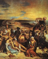
In antiquity the island was very prosperous and after the Persian wars it was an ally of Athens and then Sparta. In the 11th century AD it was taken from the Byzantines, then by the Venetians, who were succeeded by the Genoese, who formed a special company in the 14th century just for the trade of the mastich. In 1566 the Ottomans took the island from the Genoese and held it until 1922 when it joined Greece. During the Ottoman period Chios was granted many special privileges and joined the Greek revolution very reluctantly under the coercion of the Samians in 1822. The Ottoman reaction was devastating. After beheading three Chians who were hostages in Istanbul they send the Turkish armada to invade the island. On March 30, 1822 they landed on the island. Within 24 hours they massacred over 8,000 unarmed inhabitants. The horror lasted for months. Over 25,000 were killed and 47,000, mostly women, were sold into slavery. Within 6 months from the original 120,000 inhabitants only 18,000 were left. The repercussions of this tragedy were felt all over Europe. Intellectuals like Lebrun, Müller, and especially Victor Hugo with The Child of Chios and the painter Delacroix with his Massacre of Chios painting publicized the event which proved crucial for mustering support in Europe for the Greek revolution.
The production of mastich (μαστίχα- masticha) gum (Pistacia lentiscus) is a tradition particular to Chios. It is the resin of a bush that is said to grow only in this SW corner of the island. The bush does not grow very big, and at the appropriate time the growers make tiny slits on its trunk. From these slits, the gum oozes out, and it is collected. Tiny droplets are also collected from the ground, hence the sieves. The gum then is taken home, and over long hours during the winter, it is sorted according to quality and size. Families own individual bushes scattered over a wide area. The mastich gum is used as a particularly flavorful chewing gum, as a flavoring for ouzo, in a toothpaste, for a very sweet and sticky favorite of Greek children served in a spoon submerged in a glass of water and called appropriately a submarine, for folk medicines, etc. This information was given to me by one of the women I met on my way near Salagonas. During the Ottoman years, the production of mastich reached its highest point, it being the favorite chewing gum of the ladies in the seraglio because it gave them a sweet smelling mouth.
Charts
BA 1645 Nísos Khíos and Izmir Körfezi
Imray-Tetra G28 Nísos Khíos & the Coast of Turkey
NIMA 54380 Tuzla Burnu to Samos
NIMA 54386 Khios Strait Greece and Turkey
Greek 334 Chios Island & Opposite Coast of Asia Minor
Radio Nets
Also see World Cruiser's Nets
- Coast Guard - VHF channel 12 & telephone +30 22710 44 432 (Chios), +30 22720 76 239 (Limenas)
- Olympia Radio - VHF channels 85, 25, or 28
- GSM/GPRS - Very marginal coverage in the Salagonas Area
The approaches to Chios are straightforward, however,
Danger: With a strong meltemi (northerly winds) the seas on the channel, with its north going current, between Chios and the Turkish mainland can built up to dangerous levels.
Ports and Popular Stops
There are 5 harbors in Chios, 1 marina, and several coves. Also, nearby in the NE is the very attractive small island group of Oinouses.
Chios Harbor (Port of Entry)
GPS: 38°22.2′N, 26°08.7′E
This is a large and bustling harbor of a very vibrant town.
Limniá
| GPS: 38°28.1′N, 25°55.1′E Limniá (Λιμνιά) located on NW side of the island is the harbor of Volissós (Βολισσός) a picturesque town about 4 km up the hill from the harbor. It is a safe harbor providing all-weather shelter. Go stern-to on the new quay NE of the old dock used by local fishermen. There are water outlets on the quay also there are two inoperative water/electricity posts (2006). The nearest fuel station is outside of Volissós but they will deliver except on Sundays. Call VHF channel 21. Just SW of the fishing dock there is the friendly restaurant Ta Limnia (tel. +30 22710 21 014) which not only provides good food but the owner, Mr. Tsikalas, can assist you with getting fuel or renting a car. The convent of Ayia Markella is but a few km to the E of Limniá. In the village of Volissós there is wonderful wood-fired bakery. Last Visited & Details Checked (and updated here)Date of member's visit to this Port/Stop & this page's details validated:
|
Marmaro
| GPS: 38°32.7′N, 26°06.7′E
Marmaro (Μάρμαρο- marble) or Kardamyla is located on the E of N coast of Chios. It is small man-made harbor which while being protected from the meltemi allows uncomfortable swell to enter from the N and spray on jetty. Moor alongside on the S side of jetty. Fuel can be obtained from a BP station (tel. +30 22710 23 565 or 22 955) located approximately 1 km uphill from harbor. They sometimes deliver. A second BP is another km further up the road from the first. Marmaro is not a particularly interesting place but there are some nice beaches nearby. Last Visited & Details Checked (and updated here)Date of member's visit to this Port/Stop & this page's details validated:
|
Limenas
| GPS: 38°17.3′N, 25°55.8′E
The harbor of Mestá (Μεστά) or Limenas (Λιμένας) is on the S side of the W coast of Chios. While there is protection from the meltemi behind the mole, the swell can be uncomfortable. Excellent protection from the southerlies.There is plenty of docking space. Come side-to, there is at least 3 m depth. Be aware of the large car tires on the quay, they leave hard to remove black marks on the hull and fenders. There are some ugly buildings near the dock, two restaurants but no provisions. The bay looks attractive. Short (about 4 km) distance to the picturesque town of Mesta. There are regular buses to Chios. The Limenarchio (Coast Guard) here always comes to ask for the harbor dues. There is a taxi in Mesta, tel +30 6972 543 543 and one in Olympoi, tel. +30 2710 76 357 or +30 6937 937 758. Also in Pyrgi Konstantinos Tomazos (+30 22710 722 190) rents scooters. Last Visited & Details Checked (and updated here)Date of member's visit to this Port/Stop & this page's details validated:
|
Líthi
| GPS: 38°20.5′N, 25°59.5′E
Líthi (Λίθι) has a small harbor which provides good shelter from the meltemi. Dock side-to on the mole. There is room for 2-3 yachts. Alternatively you can anchor off in 5-6 m, good holding in sand but you are more exposed to the N wind. There are 3 tavernas ashore of which Kyra Despina and the 3 Adelphia have good fish. Last Visited & Details Checked (and updated here)Date of member's visit to this Port/Stop & this page's details validated:
|
Marinas & Yacht Clubs
Anchorages
Vrondaros
GPS: 38°25.2′N, 26°08.1′E
This is a very small harbor N of the town of Chios. It provides good shelter but room is very limited.
Emborio
| GPS: 38°11.2′N, 26°01.9′E
Emborio (Εμπορειό- commerce) is lovely little natural on the SE coast of Chios. It provides good shelter from the meltemi but because it is so small it good be difficult to find where to anchor. Good holding. There are a couple of tavernas ashore, telephone, and a small store with limited supplies. On the NE of the cove, and up the hill there is a Bronze Age (3rd millennium BC) excavation but there is not too much to see. If you continue along this road you come to Mavra Volia, a beautiful black pebble beach, totally deserted.
Last Visited & Details Checked (and updated here)Date of member's visit to this Port/Stop & this page's details validated:
|
Angelia, Salagonas, Trachilia, and Kato Faná
West of Cape Masticho and just before reaching Cape Mesta on the S coast of Chios there are 5 wonderful coves. All of them are well protected from the meltemi but exposed to the SW.
The easternmost cove is Kato Faná Bay (Κάτω Φανά) (GPS: 38°12.2′N, 25°55.4′E). There only here some abandoned campers. Nearby there are the ruins of a temple of Apollon and a small church. The road from here leads you to the medieval village of Olýmpoi (Ολύμποι), about 8 km away, a good walk.
Next going W is the small cove of Ayia Dynamis (Αγία Δύναμις) (GPS: 38°12.9′N, 25°54.7′E). There are a few buildings associated with a church. The road from here leads you to the medieval village of Olýmpoi, about 8 km away, a good walk. About 1.5 km from Ayia Dynamis there is the cave of Olýmpi, open every day except Mondays, 9:00-19:30 with guided tours, well worth the visit.
To the E of a promontory there is the larger Salagonas (Σαλάγωνας) (GPS: 38°13.2′N, 25°54.8′E), totally deserted, save for few people during the day harvesting the mastich.
Next, to the W of the promontory is Angelia (Αγγέλια) (GPS: 38°13.2′N, 25°54′E) with a small hamlet.
Finally the westernmost cove is the narrow inlet of Trachilia (Τραχείλια) (GPS: 38°13.2′N, 25°53.6′E), totally deserted. Anchoring is easy in all of these cove. In Trachilia it is best to take a shore line to the W shore.
About one hour walk from here, up the dirt road, there is the medieval village of Olýmpoi, well worth a visit. Turn left when you reach the paved road. The other medieval village, Mestá is about a two hour walk, turn right when you reach the paved road.
You can call for a taxi either from Mestá, tel +30 6972 543 543 or from Olýmpoi, tel. +30 2710 76 357 or +30 6937 937 758.
Last Visited & Details Checked (and updated here)
Date of member's visit to this Port/Stop & this page's details validated:
- August 2007 --Istioploos 08:37, 6 June 2008 (MDT)
Elyndas
GPS: 38°23.4′N, 25°59.4′E
Elyndas (Ελύντας) or Alindas (Αλύντας) is lovely cove on the W coast of Chios. It has a wonderful beach which when I visited it was occupied by a few campers, all local, out for the Sunday. Anchor at 10 m depth, very close to the beach. The cove looks well protected from the NW wind and it could be a good anchorage, although it is not mentioned by the pilot books. The only fault that I can find with this cove is that its water is not crystal clear but somewhat murky and greenish.
Last Visited & Details Checked (and updated here)
Date of member's visit to this Port/Stop & this page's details validated:
- June 2006 --Istioploos 08:37, 6 June 2008 (MDT)
Avloniá
GPS: 38°09.8′N, 25°59.6′E
Avloniá is a small cove about 1 M west of Cape Masticho. It is surrounded by steep cliffs and offers good protection from the meltemi. Anchor in 4 m on sand, good holding.
Last Visited & Details Checked (and updated here)
Date of member's visit to this Port/Stop & this page's details validated:
- July 2004 --Istioploos 08:37, 6 June 2008 (MDT)
Langadas
GPS: 38°28.7′N, 26°07.7′E - Chartlet
Langadas or Kolokithia is a small picturesque harbor. It is not very good with the meltemi.
Last Visited & Details Checked (and updated here)
Date of member's visit to this Port/Stop & this page's details validated:
- 1997 --Istioploos 08:37, 6 June 2008 (MDT)
Ayios Ioannis Tholis
GPS: 38°28′N, 26°08.8′E - Chartlet
Well protected from the meltemi but it is occupied by a fish farm which pollutes the water and makes this cove unattractive.
Last Visited & Details Checked (and updated here)
Date of member's visit to this Port/Stop & this page's details validated:
- 1997 --Istioploos 08:37, 6 June 2008 (MDT)
Offshore Islands
Oinousses
| GPS: 38°30.8′N, 26°13.1′E
While Oinoussa, the main island of the Oinousses (Οινούσσες) group, is the birthplace of some of Greece's wealthiest shipowners who have large villas there, it still retains the old village feeling. It is clean, quiet, non commercial, with pure island architecture. |
Oinoussa
| GPS: 38°30.8′N, 26°13.1′E
The main harbor is Oinoussa or Mandraki (Μανδράκι). It provides good all-round shelter. You can either moor at the NE quay or anchor offshore. Good holding on mud and weed bottom. Caution: Always enter the harbor from the W, the water between the little islands is too shallow and full of reefs. The town of Oinoussa is a short walk uphill from the harbor with many old houses and magnificent villas. You can also anchor on a cove Ayios Ioannis (GPS: 38°30.8′N, 26°13.8′E) just E of the harbor. Good holding and well protected from the meltemi. Last Visited & Details Checked (and updated here)Date of member's visit to this Port/Stop & this page's details validated:
|
West Cove
GPS: 38°31′N, 26°12.5′E
This an lovely cove, not very secure but good for lunch and a refreshing swim.
Last Visited & Details Checked (and updated here)
Date of member's visit to this Port/Stop & this page's details validated:
- 1997 --Istioploos 08:37, 6 June 2008 (MDT)
East Cove
GPS: 38°30.3′N, 26°14.6′E
Good shelter here and good holding on sand and light weed. Isolated.
Last Visited & Details Checked (and updated here)
Date of member's visit to this Port/Stop & this page's details validated:
- July 2002 --Istioploos 08:37, 6 June 2008 (MDT)
Pasha Island
GPS: 38°30.1′N, 26°16.5′E
There are several coves here which offer good shelter.
Routes/Passages To/From
Popular passages/routes, timing, etc.
Tourism & things to do ashore
Chios has many places worth visiting, including some particularly picturesque villages.
Town of Chios
In the town of Chios there is a new Museum with archaeological exhibits, a Byzantine Museum and an ethnological museum. The Genoese Castle of Chios is an easy walk from the harbor.
Nea Moni
About 15 km from the town there is the famous Byzantine monastery of Nea Moni, established in 1042 by the emperor Constantine the Monomachos. It has many 11 century frescoes and mosaics.
Pyrgí
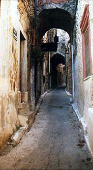
| This is a very picturesque medieval village with narrow streets and old houses whose outer walls are decorated with geometric shapes. This style of decoration is unique to Chios and is called xisti (scratched). Also in Pyrgí there the jewel of a Byzantine, 12 century AD, church dedicated to the Apostles. About 8 km from Pyrgi near the village of Ayii Pente, there are the ruins of a 6 century BC temple of Apollo. |
Mestá
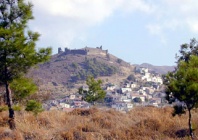
| The town of Mestá is another unspoiled medieval town with windy narrow streets built inside a Genoese castle.
There is a good restaurant O Meseonas and a taxi in Mesta, tel +30 6972 543 543. |
Olýmpoi
| The medieval walled village of Olýmpoi (Ολύμποι), although less known than Pyrgí and Mestá, has some good examples of houses decorated in the xisti style. Several of the original Genoese buildings are still standing.
About 6.5 km along the road to Ayia Dynamis there is the cave of Olýmpoi, open every day except Mondays, 9:00-19:30 with guided tours, well worth the visit. There is a taxi, tel. +30 2720 76 357 or 6937 937 758. |
Volissós
Volissós is beautiful village built on top of a steep hill has stone houses and a magnificent view. It is believed to be the birthplace of Homer. They will even show you the house tat he was born!
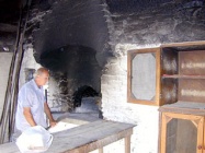
There is a wood burning bakery in Volissós that makes fantastic bread.
The Convent of Ayia Markella
Ayia Markella is the patron saint of Chios. I was told her story when I visited the convent in 1992, by an ancient nun as she was explaining a particularly vividly illustrated icon depicting the Saint's life. It is a particularly gruesome story. It happened some time in the "distant past." She grew up in a wealthy family somewhere near here. When she was maiden, "very devout," her father attacked her sexually. She took flight and hid in some bushes, her father in pursuit. In order to flush her out, he set the bushes on fire and she ran away toward the safety of the sea. He ran after her. She came upon the rocks and kept on running along the rocky shore, until finally her father caught up with her. As he was getting ready to ravish her she prayed for deliverance. The miracle happened: the rock where she was standing was opened and she sank to her waist and the rock solidified around her, thus covering the part of her anatomy her father was after. Frustrated and furious he took off his sword and cut off her breasts, blood gashing out in great streams, and she died a virgin. In the place of her martyrdom, there is today a spring of fresh water, springing from the rocks. This water is considered holy, and every year at her festival there is a great pilgrimage of the devout from the monastery to the spring to collect the holy water in all sorts of bottles which they take home for protection until the next festival. The name "Markella" is one of the most popular names in Chios.
These are very attractive fortified villages built by the Genoese, perched high on rocks. Avgonima has many renovated houses and several tavernas. Anavatos was sieged after the Massacre by the Ottomans. The inhabitants rather then by slaughtered or sold as slaves jumped off the cliff. Ever since the village has been abandoned. Now it is being restored and can be visited every day except on Mondays.
Fuel, Water, & Electricity
- Fuel: Unclear if available in the harbor of Chios Harbor. In Limniá the nearest fuel station is outside of Volissós but they will deliver except on Sundays. Call +30 22710 21 001. In Limenas there is a gas station outside Olýmpoi
- Water: Outlets on the quay in Limniá, at the shore in Chios Harbor
- Electricity: N/A
Laundry
?
Grocery Stores
- Excellent grocery shopping in the town of Chios.
- Some shopping in Volissós (excellent bread)
- Some supplies in Oinoussa
- Limited supplies in Emborio
- Limited supplies in Limniá
- No stores in Limenas
Eateries
- There are many restaurants in the town of Chios
- The Hodzas (in the town of Chios) is the oldest and famous taverna in the island
- The Petrino, along the waterfront of Chios Harbor, serves good food
- There are many restaurants in the town of Marmaro
- In Mestá try the Mesaionnas
- In Líthi Kyra Despina and the 3 Adelphia have good fish
- In Limniá there is good food in the friendly restaurant Ta Limnia (tel. 22710 21 014)
Motorbike & Car Rentals
- In the town of Chios Yiorgos Psoras (+30 22710 41 361 or 6978 775 595) will deliver a car to the marina
- In Limniá, the owner of the Ta Limnia restaurant, Mr. Tsikalas (tel. +30 22710 21 014), can assist you with renting a car
- In Limenas Konstantinos Tomazos (+30 22710 722 190) rents scooters from Pyrgí and will pick you up
Marine Stores & Facilities
In the town of Chios.
Repairs
Very limited.
Transportation
There are daily flights to Athens and many ferries. Ferry to Psara and Samos.
References & Publications
See Greece.
Cruiser's Friends
Contact details of "Cruiser's Friends" that can be contacted for local information or assistance.
Forum Discussions
List links to discussion threads on the Cruiser Log Forum
External Links
- Chios (Wikipedia)
Personal Notes
Personal experiences?
Last Visited & Details Checked (and updated here)
See individual ports in this page.
| |
|---|
| | HOMEPAGE | Wiki Contents | Mediterranean | Aegean Sea | Greece | Chios | |
.
