Cook Islands
From CruisersWiki
Lighthouse (Talk | contribs) |
Lighthouse (Talk | contribs) |
||
| Line 34: | Line 34: | ||
===Climate & Weather=== | ===Climate & Weather=== | ||
| - | + | The climate is generally warm (not too hot). The rainy season (and cyclone season) is from December to March. April to November are the winter months and the SE trade winds prevail - sudden squalls from various directions can occur during this period. | |
Sources of weather forecasting here. | Sources of weather forecasting here. | ||
| Line 62: | Line 62: | ||
===Ports & Popular Stops=== | ===Ports & Popular Stops=== | ||
| - | + | * Northern Group: | |
| + | ** [[Manihiki]] (Port of entry) | ||
| + | ** [[Penrhyn]] (Port of entry) | ||
| + | ** [[Pukapuka]] (Port of entry) | ||
| + | ** [[Suwarrow]] (Suvorov) | ||
| + | ** | ||
| - | === | + | * Southern Group: |
| - | + | ** [[Aitutaki]] (Port of entry) | |
| - | + | ** [[Atiu Island]] (Port of entry) | |
| + | ** [[Palmerston]] | ||
| + | ** [[Rarotonga]] (Port of entry) | ||
| + | ** | ||
| + | |||
| + | ===Suggested Circuit/Route Through the Group=== | ||
| + | Describe | ||
===Health=== | ===Health=== | ||
Revision as of 10:43, 12 October 2008
Cook Islands Cruising Guide
An online cruising guide for sailing around the Cook Islands.
| Cook Islands | |
 Cook Islands | |
 Flag | |
| Capital: | Avarua |
|---|---|
| Language: | English, Cook Islands Māori |
| Currency: | New Zealand dollar & Cook Islands dollar |
| Time Zone | UTC -10 |
| More notes about the country | |
Background
The Cook Islands are a self-governing parliamentary democracy in free association with New Zealand. The fifteen small islands in this South Pacific Ocean country have a total land area of 240 square kilometres (92.7 sq mi), but the Cook Islands Exclusive Economic Zone (EEZ) covers 1.8 million square kilometres (0.7 million sq mi) of ocean.
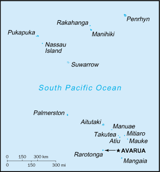
The Cook Islands are in the South Pacific Ocean, north-east of New Zealand, between French Polynesia and Fiji. There are fifteen major islands, spread over 2.2 million square kilometres of ocean, divided into two distinct groups: the Southern Cook Islands, and the Northern Cook Islands of coral atolls.
The islands were formed by volcanic activity; the northern group is older and consists of six atolls (sunken volcanoes topped by coral growth).
Describe the cruising/sailing in the region.
Climate & Weather
The climate is generally warm (not too hot). The rainy season (and cyclone season) is from December to March. April to November are the winter months and the SE trade winds prevail - sudden squalls from various directions can occur during this period.
Sources of weather forecasting here.
Charts
Submit details of the charts required for safe navigation of the area.
Any navigation notes here.
Local Radio Nets
Also see Cruiser's Nets
Arrival/Departure procedures
Submit any details about advance notification of arrival, etc.
Immigration
Details?
Customs
Details?
Ports & Popular Stops
- Northern Group:
- Southern Group:
- Aitutaki (Port of entry)
- Atiu Island (Port of entry)
- Palmerston
- Rarotonga (Port of entry)
Suggested Circuit/Route Through the Group
Describe
Health
Submit any health warnings/information and any security details here.
Security
Details?
Transportation
Transportation to mainland or other countries, etc.
References & Publications
Books, Guides, etc.
References & Publications
Publications, Guides, etc.
Cruiser's Friends
Contact details of "Cruiser's Friends" that can be contacted for local information or assistance.
Forum Discussions
List links to discussion threads on the Cruiser Log Forum
External Links
Personal Notes
Personal experiences?
| |
|---|
| | HOMEPAGE | Wiki Contents | South Pacific | Cook Islands | |
.