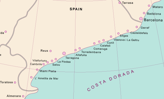
Costa Dorada
From CruisersWiki
(Difference between revisions)
Istioploos (Talk | contribs) (→Ports, Anchorages, and Islands: Marinas) |
Istioploos (Talk | contribs) (New Material) |
||
| Line 5: | Line 5: | ||
==Navigation Charts== | ==Navigation Charts== | ||
| - | ; | + | ; British Admiralty (BA) |
| - | : | + | : 518 Approaches to Puerto de Valencia |
| - | : | + | : 1195 Approaches to Puerto de Barcelona |
| - | ; | + | : 1701 Cabo de San Antonio to Villanueva y Geltrú including Islas de Ibiza and Formentera |
| - | : | + | : 2717 Cadiz to Barcelona |
| - | : | + | ; National Imagery and Mapping Agency (NIMA) |
| + | : 52080 Cabo de Palos to Vinaroz | ||
| + | : 52085 Approaches to Valencia | ||
| + | : 52120 Vilaroz to Cabo Creus | ||
| + | : 52121 Tarragona and Approaches | ||
| + | : 52122 Barcelona and Approaches | ||
| - | =Weather and Winds== | + | ==Weather and Winds== |
{{GreenText|Give weather conditions in the region or refer to another page (a country?) that covers these conditions.}} | {{GreenText|Give weather conditions in the region or refer to another page (a country?) that covers these conditions.}} | ||
| Line 85: | Line 90: | ||
|} | |} | ||
| - | |||
[[Category:Regions - Spain]] | [[Category:Regions - Spain]] | ||
Revision as of 19:58, 29 April 2013
Costa Dorada
Costa Daurada (Catalan pronunciation: [ˈkɔstə ðəwˈɾaðə], Spanish: Costa Dorada, meaning in English "Golden Coast") is an area on the coast of Catalonia, Spain, between Cunit and Alcanar on the Mediterranean Sea.- British Admiralty (BA)
- 518 Approaches to Puerto de Valencia
- 1195 Approaches to Puerto de Barcelona
- 1701 Cabo de San Antonio to Villanueva y Geltrú including Islas de Ibiza and Formentera
- 2717 Cadiz to Barcelona
- National Imagery and Mapping Agency (NIMA)
- 52080 Cabo de Palos to Vinaroz
- 52085 Approaches to Valencia
- 52120 Vilaroz to Cabo Creus
- 52121 Tarragona and Approaches
- 52122 Barcelona and Approaches
Weather and Winds
Give weather conditions in the region or refer to another page (a country?) that covers these conditions.
Sources for weather information:
Currents & Tides
Any navigation notes here. If this section does not apply remove it.
Regional Radio Nets
Also see World Cruiser's Nets.
Ports, Anchorages, and Islands
![]() = Port of Entry,
= Port of Entry, ![]() = Island,
= Island, ![]() = Marina,
= Marina, ![]() = Harbor,
= Harbor, ![]() = Anchorage,
= Anchorage, ![]() = Needs data.
= Needs data.
- Valencia


- Reial Club Maritim de Barcelona (RCMB)

- Port Vell Marina

- Orpesa


- Sant Charles de la Rapita


- Tarragona


- Barcelona


Routes/Passages To/From
See Aegean to West Mediterranean Passages.
Cruiser's Friends
Contact details of "Cruiser's Friends" that can be contacted for local information or assistance.
Forum Discussions
List links to discussion threads on partnering forums. (see link for requirements)
External Links
Personal Notes
Personal experiences?
Last Visited & Details Checked (and updated here)
Date of member's visit to this Port/Stop & this page's details validated:
|
|---|
|
Names: Lighthouse |
| |
|---|
| | HOMEPAGE | Wiki Contents | Mediterranean | Spain | MedSpain | Costa Dorada | |
