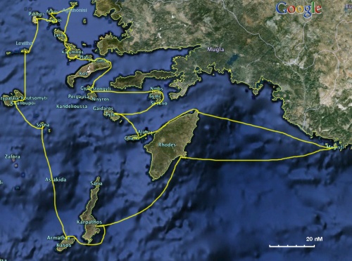
Cruising the Dodecanese Islands
From CruisersWiki
Istioploos (Talk | contribs) (New (not done yet)) |
Lighthouse (Talk | contribs) (Added links to Nav Bar) |
||
| Line 75: | Line 75: | ||
! <h2 id="mp-itn-h2" style="margin:0; background:#cedff2; font-size:120%; font-weight:bold; border:1px solid #a3b0bf; text-align:left; color:#000; padding:0.2em 0.4em;">Cruising Wiki Navigation</h2> | ! <h2 id="mp-itn-h2" style="margin:0; background:#cedff2; font-size:120%; font-weight:bold; border:1px solid #a3b0bf; text-align:left; color:#000; padding:0.2em 0.4em;">Cruising Wiki Navigation</h2> | ||
|- | |- | ||
| - | |style="color:#000;"| | [[Cruising_and_Sailing_Wiki_by_CruiserLog|HOMEPAGE]] | [[ | + | |style="color:#000;"| | [[Cruising_and_Sailing_Wiki_by_CruiserLog|HOMEPAGE]] | [[Cruising|Wiki Contents]] | [[Med|Mediterranean]] | [[Greece]] | [[Turkey]] | [[Aegean Sea]] | [[Cruising the Dodechanese Islands]] | |
|} | |} | ||
Revision as of 05:51, 19 November 2009
Cruise of the Dodechanese Islands
| Cruise of the Dodechanese | |
| MORE notes about the passage |
Introduction
?
Climate & Weather Information
In the summer months the weather is dominated by the meltemi which comes from the NW.
For details see Aegean Weather.
Weather Windows
The best times to tour the Dodechanese are in the Spring, May to June, and in the autumn, September to October. You are less likely to encounter strong meltemi winds and also all the anchorages are less crowded. Other than the weather-wise unpredictable winter months, the worse time to be cruising the Sea of Samos is during the month of August. In August not only will you encounter a number of "meltemi" gales but all harbors and anchorages, even the most remote, will be crowded as this is the prime vacation time in Greece and the rest of the EU.
In October, especially late in the month there can be southerly winds and occasionally thunderstorms, some of which can be severe. If you are cruising during that time you should always have two possible anchorages in mind: one protected from N winds and one from the S winds.
Radio Nets
See Aegean Sea
- Chart Source
- Chart Number
Passage Description
FULL description of this passage.
Distance & Duration
- Distance =
- Duration =
Possible Departure Points
Route/Suggested Stopovers
(In sequence)
Possible Arrival Ports
CruiserLog Forum discussions
Links to discussions on the CruiserLog Forum
External Links
See Aegean Sea.
References
See Aegean Sea.
Personal Notes
- I have sailed almost all of the above passages. --Istioploos

| |
|---|
| | HOMEPAGE | Wiki Contents | Mediterranean | Greece | Turkey | Aegean Sea | Cruising the Dodechanese Islands | |
.
