Datca
From CruisersWiki
m (→Background) |
Istioploos (Talk | contribs) (Reformated) |
||
| Line 1: | Line 1: | ||
==Datça (Port of entry)== | ==Datça (Port of entry)== | ||
| - | {| | + | {| class="infobox bordered" style="width: 33em; text-align: left; font-size: 85%;" |
|- | |- | ||
| - | | | + | | colspan="2" style="text-align:center; font-size: smaller;" | {{Small info}} (''Click links for more information'') |
| - | + | |- | |
| - | |} | + | ! <center>[[image:World_icon.png]]</center> |
| - | + | | {{Coord|36|43.3|N|27|41.5|E|}} | |
| - | + | |- | |
| + | ! <center>[[image:Photo_icon.png]]</center> | ||
| + | | [http://www.panoramio.com/map/#lt=36.722805&ln=27.688358&z=0&k=0&a=1&tab=2 Photo gallery] | ||
| + | |- | ||
| + | ! <center>[[image:Chart_icon.png]]</center> | ||
| + | | [http://mapserver.mytopo.com/homepage/index.cfm?lat=36.721667&lon=27.691667&scale=100000&zoom=50&type=0&icon=0&searchscope=dom&CFID=17583484&CFTOKEN=79232580&scriptfile=http://mapserver.mytopo.com/homepage/index.cfm&latlontype=DMS Local chartlet] | ||
| + | |} | ||
| - | |||
[http://en.wikipedia.org/wiki/Datca Datça] used to be a pleasant harbor of a sleepy provincial town. In the last few years it has grown to a booming resort with high-rise buildings, bars, and extremely noisy discos. Sleeping in the harbor is problematical due to the cacophony of many competing discos and bars. Still it is a fairly convenient port of entry and exit. | [http://en.wikipedia.org/wiki/Datca Datça] used to be a pleasant harbor of a sleepy provincial town. In the last few years it has grown to a booming resort with high-rise buildings, bars, and extremely noisy discos. Sleeping in the harbor is problematical due to the cacophony of many competing discos and bars. Still it is a fairly convenient port of entry and exit. | ||
| Line 16: | Line 21: | ||
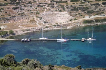
[[Image:Datca.jpeg|center|thumb|250px|Datca waterfront]] | [[Image:Datca.jpeg|center|thumb|250px|Datca waterfront]] | ||
| - | + | ==Charts== | |
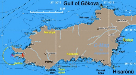
| + | [[Image:Turkey_Datca_r.jpg|450px|thumb|right|The Region of Datça & Cape Krio<br/>''Click for larger view'']] | ||
| + | |||
;BA | ;BA | ||
:1055 Rhodes Channel and Gökova Körfezi | :1055 Rhodes Channel and Gökova Körfezi | ||
| Line 29: | Line 36: | ||
:451 Leros to Rhodos | :451 Leros to Rhodos | ||
| - | + | ==Radio Nets== | |
''Also see [[HF_Radio|Cruiser's Nets]]'' | ''Also see [[HF_Radio|Cruiser's Nets]]'' | ||
* No GSM/GPRS in [[#Cove_East_of_Kalaboshi|Kalaboshi Cove]] | * No GSM/GPRS in [[#Cove_East_of_Kalaboshi|Kalaboshi Cove]] | ||
| - | ===Approach and Navigation | + | ==Local Weather== |
| + | ''See [[Turkey#Turkey_Climate_&_Weather|Turkey]]'' | ||
| + | |||
| + | ==Approach and Navigation== | ||
Approaches to the region are straightforward but, | Approaches to the region are straightforward but, | ||
<font color="red">Danger:</font> There are fierce gusts of Cape Krio and along the steep slopes to Datça. | <font color="red">Danger:</font> There are fierce gusts of Cape Krio and along the steep slopes to Datça. | ||
| - | + | ==Check-in facilities== | |
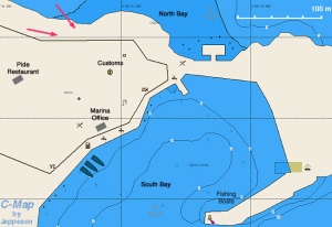
| - | + | [[Image:Turkey_Datca_h.jpg|300px|thumb|right|Chart of Datça Harbor - [http://mapserver.maptech.com/homepage/index.cfm?lat=36.721667&lon=27.691667&scale=100000&zoom=100&type=0&icon=0&searchscope=dom&CFID=2448100&CFTOKEN=51416738&scriptfile=http://mapserver.maptech.com/homepage/index.cfm&latlontype=DMS Chartlet]<br/>''Click for larger view'']] | |
| - | | | + | |
| - | + | It is possible to anchor off-shore in either the South or North Bay which would provide some protection from the noise. The marina in the South Bay is well attended and the attendant will show you where to dock. You have to drop an anchor and come stern-to. | |
| - | + | ||
| - | + | <div style="clear: both;"></div> | |
| - | + | ==Offshore Islands== | |
| + | ====Baba Adasi==== | ||
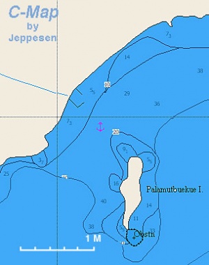
| + | [[Image:Turkey_Datca_Baba_m.jpg|300px|thumb|right|Chart of Baba Adasi<br/>''Click for larger view'']] | ||
| - | + | GPS: {{Coord|36|39.7|N|27|30.4|E|}} - [http://mapserver.maptech.com/homepage/index.cfm?lat=36.661667&lon=27.506667&scale=100000&zoom=100&type=0&icon=0&searchscope=dom&CFID=2448100&CFTOKEN=51416738&scriptfile=http://mapserver.maptech.com/homepage/index.cfm&latlontype=DMS Chartlet]<br /> | |
| - | + | ||
| - | GPS: {{Coord|36| | + | A pleasant enough anchorage. Anchor in 7 m, good holding. It is safe from the ''meltemi''. |
| - | A pleasant enough | + | |
<font color="red">Warning:</font> There are many bees here, and they bite. | <font color="red">Warning:</font> There are many bees here, and they bite. | ||
| Line 57: | Line 66: | ||
=====Last Visited & Details Checked (and updated here)===== | =====Last Visited & Details Checked (and updated here)===== | ||
''Date of member's visit to this Port/Stop & this page's details validated'': | ''Date of member's visit to this Port/Stop & this page's details validated'': | ||
| - | * | + | * 1985 --[[User:Istioploos|Istioploos]] [[Image:Greece_Icon.png]] |
* | * | ||
| - | == | + | ==Marinas & Yacht Clubs== |
| - | + | * [[Datca Marina]] | |
| - | + | ||
| - | [ | + | |
| - | + | ||
| - | + | ||
| - | + | ||
| - | + | ||
| - | + | ||
| - | + | ||
| - | + | ||
| - | + | ||
| - | + | ||
| - | + | ||
| - | + | ||
| + | ==Anchorages== | ||
| + | ====Cove East of Kalaboshi==== | ||
| + | GPS: {{Coord|36|40.7|N|27|36.7|E|}} - [http://mapserver.maptech.com/homepage/index.cfm?lat=36.678333&lon=27.611667&scale=100000&zoom=100&type=0&icon=0&searchscope=dom&CFID=2448100&CFTOKEN=51416738&scriptfile=http://mapserver.maptech.com/homepage/index.cfm&latlontype=DMS Chartlet]<br /> | ||
| + | A pleasant enough cove about 2 nM E of Kalaboshi. Anchor in 7 m, good holding. It is safe from the ''meltemi'' but a strong and possibly uncomfortable swell enters the cove. | ||
| + | <font color="red">Warning:</font> There are many bees here, and they bite. | ||
| + | =====Last Visited & Details Checked (and updated here)===== | ||
| + | ''Date of member's visit to this Port/Stop & this page's details validated'': | ||
| + | * August 2002 --[[User:Istioploos|Istioploos]] [[Image:Greece_Icon.png]] | ||
| + | * | ||
| + | <div style="clear: both;"></div> | ||
| + | ====Knidos==== | ||
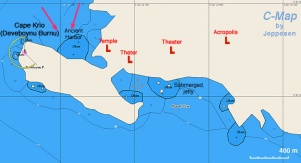
| + | [[Image:Turkey_Knidos_m.jpg|301px|thumb|right|Chart of the Knidos Anchorage - [http://mapserver.maptech.com/homepage/index.cfm?lat=36.683333&lon=27.383333&scale=100000&zoom=100&type=0&icon=0&searchscope=dom&CFID=2448100&CFTOKEN=51416738&scriptfile=http://mapserver.maptech.com/homepage/index.cfm&latlontype=DMS Chartlet]<br/>''Click for larger view'']] | ||
| + | GPS: {{Coord|36|41|N|27|23|E|}}<br /> | ||
| + | [http://en.wikipedia.org/wiki/Knidos Knidos] or Büyük Liman is a nice anchorage off Cape Krio. It is usually crowded but the extensive archaeological site is a "must see" place. This was a place sacred to [http://www.maicar.com/GML/Aphrodite.html Aphrodite], the goddess of love and beauty. Here was the [http://en.wikipedia.org/wiki/Aphrodite_of_Cnidus statue of Aphrodite] by [http://en.wikipedia.org/wiki/Praxiteles Praxiteles] that was famous throughout the ancient world. It was not been found. | ||
| + | Anchor on either side of the bay wherever there is space. The holding is uncertain in some areas because of rocks and weed on the bottom, so be prepared to make several attempts. Make sure the anchor is well set before opening the Efes since the gusts can be strong even in moderate winds. Alternatively, go alongside either side of the refurbished restaurant pontoon, where there is space for around eight yachts (more when rafted up). You will be expected to eat in the restaurant ashore if you moor here. | ||
=====Last Visited & Details Checked (and updated here)===== | =====Last Visited & Details Checked (and updated here)===== | ||
''Date of member's visit to this Port/Stop & this page's details validated'': | ''Date of member's visit to this Port/Stop & this page's details validated'': | ||
| - | * 1985 --[[User:Istioploos|Istioploos]] | + | * 1985 --[[User:Istioploos|Istioploos]] [[Image:Greece_Icon.png]] |
* July 2009 --[[User:Atheneoflymington|Atheneoflymington]] 11:42, 11 July 2009 (UTC) | * July 2009 --[[User:Atheneoflymington|Atheneoflymington]] 11:42, 11 July 2009 (UTC) | ||
| - | + | [[Image:Knidos.jpeg|350px|thumb|center|Knidos]] | |
| - | + | ||
====Mersinçik==== | ====Mersinçik==== | ||
| - | + | [[Image:Datca_Mersincik.jpg|250px|thumb|right|The Mersinçik Anchorage<br/>''Click for larger view'']] | |
| - | | | + | |
| + | GPS: {{Coord|36|45.2|N|27|28.8|E|}} - [http://mapserver.maptech.com/homepage/index.cfm?lat=36.753333&lon=27.48&scale=100000&zoom=100&type=0&icon=0&searchscope=dom&CFID=2448100&CFTOKEN=51416738&scriptfile=http://mapserver.maptech.com/homepage/index.cfm&latlontype=DMS Chartlet]<br /> | ||
Mersinçik has two possible anchorages: a narrow cove NW and a larger bay to the S. Both are very attractive and secure but the NW cove is very popular with ''gulets''. Anchor in 8 m, good holding. It is best to take a stern line to a tree. | Mersinçik has two possible anchorages: a narrow cove NW and a larger bay to the S. Both are very attractive and secure but the NW cove is very popular with ''gulets''. Anchor in 8 m, good holding. It is best to take a stern line to a tree. | ||
=====Last Visited & Details Checked (and updated here)===== | =====Last Visited & Details Checked (and updated here)===== | ||
''Date of member's visit to this Port/Stop & this page's details validated'': | ''Date of member's visit to this Port/Stop & this page's details validated'': | ||
| - | * August 2004 --[[User:Istioploos|Istioploos]] | + | * August 2004 --[[User:Istioploos|Istioploos]] [[Image:Greece_Icon.png]] |
* | * | ||
| - | + | ==Yacht Repairs and Services== | |
| - | + | ====Marine Stores==== | |
| + | None. | ||
| - | === | + | ====Repairs/Yards==== |
| - | + | None. | |
| - | + | ||
| - | + | ||
| - | + | ||
| - | + | ====Fuel, Water, & Electricity==== | |
| + | ; Fuel | ||
| + | : At the [[Datca_Marina|marina]]. | ||
| + | ; Water | ||
| + | : At the [[Datca_Marina|marina]]. | ||
| + | ; Electricity | ||
| + | : At the [[Datca_Marina|marina]]. | ||
| - | == | + | ==Tourism and Things to do Ashore== |
| - | + | ===Tourism=== | |
| - | + | ||
| - | + | ||
| - | + | ||
| - | + | ||
| - | + | ||
| - | + | ||
| - | + | ||
| - | + | ||
| - | + | ||
| - | ===Tourism | + | |
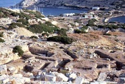
[[Image:Knidos2.jpg|250px|thumb|right|center|The Antiquities in Knidos<br/>''Click for larger view'']] | [[Image:Knidos2.jpg|250px|thumb|right|center|The Antiquities in Knidos<br/>''Click for larger view'']] | ||
Visit the ancient site of Knidos. | Visit the ancient site of Knidos. | ||
| - | + | ===Grocery & Supply Stores=== | |
| - | + | ||
| - | + | ||
| - | + | ||
| - | + | ||
| - | + | ||
| - | ===Grocery Stores=== | + | |
Several stores in the town of Datça. | Several stores in the town of Datça. | ||
| Line 139: | Line 138: | ||
* In the town of Datça there are many restaurants. Some very reasonably priced specializing in ''pide'' (a Turkish pizza) to the right of the main road leading inland | * In the town of Datça there are many restaurants. Some very reasonably priced specializing in ''pide'' (a Turkish pizza) to the right of the main road leading inland | ||
* There are several overpriced restaurants in [[#Knidos|Knidos]] | * There are several overpriced restaurants in [[#Knidos|Knidos]] | ||
| + | |||
| + | ===Internet/WiFi=== | ||
| + | ? | ||
| + | |||
| + | ===Laundry=== | ||
| + | ? | ||
===Motorbike & Car Rentals=== | ===Motorbike & Car Rentals=== | ||
In the town of Datça. | In the town of Datça. | ||
| - | === | + | ===Garbage Disposal=== |
| - | + | There are bins around the harbor. | |
| - | + | ||
| - | + | ||
| - | + | ||
===Transportation=== | ===Transportation=== | ||
Only by car. | Only by car. | ||
| - | == | + | ==Routes/Passages To/From== |
| - | See [[ | + | See [[Aegean_Sea#Passages|Aegean]]. |
| - | + | ==Cruiser's Friends== | |
Contact details of "Cruiser's Friends" that can be contacted for local information or assistance. | Contact details of "Cruiser's Friends" that can be contacted for local information or assistance. | ||
| - | + | ==Forum Discussions== | |
List links to discussion threads on the Cruiser Log Forum | List links to discussion threads on the Cruiser Log Forum | ||
* | * | ||
| Line 164: | Line 166: | ||
* | * | ||
| - | + | ==External Links== | |
* [http://en.wikipedia.org/wiki/Datca Datça] (Wikipedia) | * [http://en.wikipedia.org/wiki/Datca Datça] (Wikipedia) | ||
* [http://en.wikipedia.org/wiki/Knidos Knidos] (Wikipedia) | * [http://en.wikipedia.org/wiki/Knidos Knidos] (Wikipedia) | ||
* | * | ||
| - | == | + | ==References & Publications== |
| - | + | See [[Turkey#References_&_Publications| Turkey]]. | |
| - | + | ==Last Visited & Details Checked (and updated here)== | |
See individual ports in this page. | See individual ports in this page. | ||
| + | ==Personal Notes== | ||
| + | Personal experiences? | ||
{{Guide2}} | {{Guide2}} | ||
| Line 184: | Line 188: | ||
|style="color:#000;"| | [[Cruising_and_Sailing_Wiki_by_CruiserLog|HOMEPAGE]] | [[Cruising|Wiki Contents]] | [[Med|Mediterranean]] | [[Aegean Sea]] | [[Turkey]] | [[Datca]] | | |style="color:#000;"| | [[Cruising_and_Sailing_Wiki_by_CruiserLog|HOMEPAGE]] | [[Cruising|Wiki Contents]] | [[Med|Mediterranean]] | [[Aegean Sea]] | [[Turkey]] | [[Datca]] | | ||
|} | |} | ||
| + | |||
| + | |||
| + | [[Category:Ports - Turkey]] | ||
| + | |||
. | . | ||
Revision as of 06:15, 10 May 2010
Datça (Port of entry)
| | |
| | 36°43.3′N, 27°41.5′E |
|---|---|
| | Photo gallery |
| | Local chartlet |
Datça used to be a pleasant harbor of a sleepy provincial town. In the last few years it has grown to a booming resort with high-rise buildings, bars, and extremely noisy discos. Sleeping in the harbor is problematical due to the cacophony of many competing discos and bars. Still it is a fairly convenient port of entry and exit.
Yachts anchor moor to the quay with the help of harbour staff. Water and electricity are available on the quay.
There are several anchorages along the way from Datça to Cape Krio.
Charts
- BA
- 1055 Rhodes Channel and Gökova Körfezi
- Imray-Tetra
- G35 Dodecanese and Coast of Turkey
- NIMA
- 54400 Samos to Rodhos
- Turkey
- 311 Marmaris - Fethiye
- 3112 E) Datça Limanı
- Greek
- 451 Leros to Rhodos
Radio Nets
Also see Cruiser's Nets
- No GSM/GPRS in Kalaboshi Cove
Local Weather
See Turkey
Approaches to the region are straightforward but,
Danger: There are fierce gusts of Cape Krio and along the steep slopes to Datça.
Check-in facilities
It is possible to anchor off-shore in either the South or North Bay which would provide some protection from the noise. The marina in the South Bay is well attended and the attendant will show you where to dock. You have to drop an anchor and come stern-to.
Offshore Islands
Baba Adasi
GPS: 36°39.7′N, 27°30.4′E - Chartlet
A pleasant enough anchorage. Anchor in 7 m, good holding. It is safe from the meltemi.
Warning: There are many bees here, and they bite.
Last Visited & Details Checked (and updated here)
Date of member's visit to this Port/Stop & this page's details validated:
- 1985 --Istioploos

Marinas & Yacht Clubs
Anchorages
Cove East of Kalaboshi
GPS: 36°40.7′N, 27°36.7′E - Chartlet
A pleasant enough cove about 2 nM E of Kalaboshi. Anchor in 7 m, good holding. It is safe from the meltemi but a strong and possibly uncomfortable swell enters the cove.
Warning: There are many bees here, and they bite.
Last Visited & Details Checked (and updated here)
Date of member's visit to this Port/Stop & this page's details validated:
- August 2002 --Istioploos

Knidos
GPS: 36°41′N, 27°23′E
Knidos or Büyük Liman is a nice anchorage off Cape Krio. It is usually crowded but the extensive archaeological site is a "must see" place. This was a place sacred to Aphrodite, the goddess of love and beauty. Here was the statue of Aphrodite by Praxiteles that was famous throughout the ancient world. It was not been found.
Anchor on either side of the bay wherever there is space. The holding is uncertain in some areas because of rocks and weed on the bottom, so be prepared to make several attempts. Make sure the anchor is well set before opening the Efes since the gusts can be strong even in moderate winds. Alternatively, go alongside either side of the refurbished restaurant pontoon, where there is space for around eight yachts (more when rafted up). You will be expected to eat in the restaurant ashore if you moor here.
Last Visited & Details Checked (and updated here)
Date of member's visit to this Port/Stop & this page's details validated:
- 1985 --Istioploos

- July 2009 --Atheneoflymington 11:42, 11 July 2009 (UTC)
Mersinçik
GPS: 36°45.2′N, 27°28.8′E - Chartlet
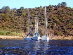
Mersinçik has two possible anchorages: a narrow cove NW and a larger bay to the S. Both are very attractive and secure but the NW cove is very popular with gulets. Anchor in 8 m, good holding. It is best to take a stern line to a tree.
Last Visited & Details Checked (and updated here)
Date of member's visit to this Port/Stop & this page's details validated:
- August 2004 --Istioploos

Yacht Repairs and Services
Marine Stores
None.
Repairs/Yards
None.
Fuel, Water, & Electricity
Tourism and Things to do Ashore
Tourism
Visit the ancient site of Knidos.
Grocery & Supply Stores
Several stores in the town of Datça.
Eateries
- In the town of Datça there are many restaurants. Some very reasonably priced specializing in pide (a Turkish pizza) to the right of the main road leading inland
- There are several overpriced restaurants in Knidos
Internet/WiFi
?
Laundry
?
Motorbike & Car Rentals
In the town of Datça.
Garbage Disposal
There are bins around the harbor.
Transportation
Only by car.
Routes/Passages To/From
See Aegean.
Cruiser's Friends
Contact details of "Cruiser's Friends" that can be contacted for local information or assistance.
Forum Discussions
List links to discussion threads on the Cruiser Log Forum
External Links
References & Publications
See Turkey.
Last Visited & Details Checked (and updated here)
See individual ports in this page.
Personal Notes
Personal experiences?
| |
|---|
| | HOMEPAGE | Wiki Contents | Mediterranean | Aegean Sea | Turkey | Datca | |
.

