Faro
From CruisersWiki
m (Text replace - "{{Guide2" to "{{page useable") |
Istioploos (Talk | contribs) (Chartlet) |
||
| Line 1: | Line 1: | ||
| - | ==Faro, Portugal== | + | ==Faro, Portugal (Port of Entry)== |
| - | { | + | {{Infobox |36|58.49|N|07|52.36|W| |
| - | + | | mapzoom= 13 | |
| - | + | | image= RiaFormosa.jpg | |
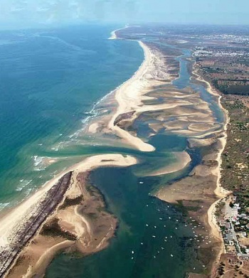
| - | + | | imagetext= View of Parque Natural da Ria Formosa(Faro is at top of picture)<br/>''Click for larger view'' | |
| - | + | }} {{TOCleft}} | |
| - | + | ||
| - | | | + | |
| - | + | ||
| - | + | ||
| - | | | + | |
| - | + | ||
| - | + | ||
| - | | | + | |
| - | + | ||
| - | + | ||
Faro, the capital of the Algarve region of [[Portugal]], is situated at the southern end of the beautiful Parque Natural da Ria Formosa between [[Vilamoura]] 15 miles to the west and [[Vila Real de Santo Antonio]] on the Portuguese-Spanish border 30 miles to the east. There was already an important settlement here during the Roman era, when it was known as Ossonoba. From the 8th to the 13th centuries it was under Moorish rule, which only ended with the defeat of the Moors at the hands of King Alfonso III in 1249. The town’s position - at the head of a tidal channel protected by the natural breakwater of Ilha da Barreta - saved it from the worst effects of the 1755 earthquake and tsunami and the administrative centre of the Algarve was consequently transferred here from Lagos. The old town has some attractive squares and buildings, although most land-based visitors here pass quickly through the town’s airport on the way to their Algarve holiday hotels. Cruising visitors, however, have ample opportunity to appreciate the beauties of the natural lagoon of the Ria Formosa nature park with its sheltered anchorages and spectacular bird life. | Faro, the capital of the Algarve region of [[Portugal]], is situated at the southern end of the beautiful Parque Natural da Ria Formosa between [[Vilamoura]] 15 miles to the west and [[Vila Real de Santo Antonio]] on the Portuguese-Spanish border 30 miles to the east. There was already an important settlement here during the Roman era, when it was known as Ossonoba. From the 8th to the 13th centuries it was under Moorish rule, which only ended with the defeat of the Moors at the hands of King Alfonso III in 1249. The town’s position - at the head of a tidal channel protected by the natural breakwater of Ilha da Barreta - saved it from the worst effects of the 1755 earthquake and tsunami and the administrative centre of the Algarve was consequently transferred here from Lagos. The old town has some attractive squares and buildings, although most land-based visitors here pass quickly through the town’s airport on the way to their Algarve holiday hotels. Cruising visitors, however, have ample opportunity to appreciate the beauties of the natural lagoon of the Ria Formosa nature park with its sheltered anchorages and spectacular bird life. | ||
| + | |||
| + | ==Local Weather== | ||
| + | {{GreenText|Give local weather conditions or refer to another page (a region or island group) that covers these conditions.}} | ||
| + | |||
| + | Sources for Weather forecasts: | ||
| + | * ''See also [[Portugal#Climate_.26_Weather|Portugal]]''. | ||
| + | * | ||
==Charts== | ==Charts== | ||
{{GreenText|Please provide a good map or chart that clearly shows details (depths, where to dock, scale etc.) of the harbor.}} | {{GreenText|Please provide a good map or chart that clearly shows details (depths, where to dock, scale etc.) of the harbor.}} | ||
| - | |||
{{GreenText|Give charts applicable to this port or refer to a Chart section of another page (Country or Region) that lists the charts.}} | {{GreenText|Give charts applicable to this port or refer to a Chart section of another page (Country or Region) that lists the charts.}} | ||
| Line 33: | Line 29: | ||
* | * | ||
| - | ''Also see [[World MM Nets|World Cruiser's Nets]]''. | + | ''Also see [[World MM Nets|World Cruiser's Nets]]''. |
| - | == | + | ==Approach and Navigation== |
| - | + | The channel up to Faro is entered via a 200-metre wide gap through two training walls ([[image:World_icon.png]] {{Coord|36|57.44|N|07|52.12|W|}}). Although it is possible for all but deep-draught yachts to navigate the channel up to Faro at any state of tide, it is best to arrive at half tide and enter with the flow. While the channel up to Faro is buoyed (except for the last 500 metres up to the anchorage) it is easy to run aground and therefore it is less frustrating to enter on a rising tide. If arriving on the ebb, be aware that the tidal current can run at 3-4 knots at springs. | |
| - | + | ==Check-in facilities (Customs and Immigration)== | |
| - | + | [[Faro]] iis a port of entry/exit to [[Portugal]]. | |
| - | + | {{GreenText|Please submit details about facilities for checking-in, location of immigration & customs, etc.}} | |
| - | + | ||
| - | ==Berthing | + | ==Berthing Options== |
===Marinas & Yacht Clubs=== | ===Marinas & Yacht Clubs=== | ||
None (the marina at Faro is suitable for small motor boats only). | None (the marina at Faro is suitable for small motor boats only). | ||
| Line 58: | Line 53: | ||
==Yacht Repairs and Services== | ==Yacht Repairs and Services== | ||
====Marine Stores==== | ====Marine Stores==== | ||
| - | Submit addresses and contact details of marine related businesses that are of interest to cruisers. | + | {{GreenText|Submit addresses and contact details of marine related businesses that are of interest to cruisers.}} |
| + | * | ||
* | * | ||
====Repairs/Yards==== | ====Repairs/Yards==== | ||
| - | Quinta do Progresso Boatyard north of the anchorage (details needed). | + | Quinta do Progresso Boatyard north of the anchorage {{GreenText|(details needed)}}. |
====Fuel, Water, & Electricity==== | ====Fuel, Water, & Electricity==== | ||
| Line 79: | Line 75: | ||
====Grocery & Supply Stores==== | ====Grocery & Supply Stores==== | ||
| - | Provisions shops in old town | + | Provisions shops in old town. |
| - | + | ||
====Eateries==== | ====Eateries==== | ||
| Line 97: | Line 92: | ||
====Transportation==== | ====Transportation==== | ||
| - | + | {{GreenText|List transportation (local and/or international.)}} | |
* | * | ||
==Routes/Passages To/From== | ==Routes/Passages To/From== | ||
| - | + | ''See [[Portugal#References_.26_Publications|Portugal]]''. | |
| - | + | ||
==Cruiser's Friends== | ==Cruiser's Friends== | ||
| Line 113: | Line 107: | ||
==External Links== | ==External Links== | ||
| - | + | * {{wikipedia|Faro,_Portugal}} | |
* | * | ||
| Line 129: | Line 123: | ||
| - | {{ | + | {{Page useable}} |
| - | + | ||
| - | |||
| - | |||
| - | |||
| - | |||
| - | |||
| - | |||
| - | |||
| - | |||
| - | + | {{Contributors|[[User:Lighthouse|Lighthouse]], [[User:Atheneoflymington|Athene of Lymington]]}} | |
| - | { | + | |
| - | + | ||
| - | + | ||
| - | + | ||
| - | + | ||
| + | {{Navbar| [[North Atlantic]] | [[Portugal]] | [[Faro]] }} | ||
[[Category:Anchorages - Portugal]] | [[Category:Anchorages - Portugal]] | ||
Revision as of 14:32, 5 February 2016
Faro, Portugal (Port of Entry)
| Faro
| |
Faro, the capital of the Algarve region of Portugal, is situated at the southern end of the beautiful Parque Natural da Ria Formosa between Vilamoura 15 miles to the west and Vila Real de Santo Antonio on the Portuguese-Spanish border 30 miles to the east. There was already an important settlement here during the Roman era, when it was known as Ossonoba. From the 8th to the 13th centuries it was under Moorish rule, which only ended with the defeat of the Moors at the hands of King Alfonso III in 1249. The town’s position - at the head of a tidal channel protected by the natural breakwater of Ilha da Barreta - saved it from the worst effects of the 1755 earthquake and tsunami and the administrative centre of the Algarve was consequently transferred here from Lagos. The old town has some attractive squares and buildings, although most land-based visitors here pass quickly through the town’s airport on the way to their Algarve holiday hotels. Cruising visitors, however, have ample opportunity to appreciate the beauties of the natural lagoon of the Ria Formosa nature park with its sheltered anchorages and spectacular bird life.
Local Weather
Give local weather conditions or refer to another page (a region or island group) that covers these conditions.
Sources for Weather forecasts:
- See also Portugal.
Charts
Please provide a good map or chart that clearly shows details (depths, where to dock, scale etc.) of the harbor.
Give charts applicable to this port or refer to a Chart section of another page (Country or Region) that lists the charts.
- Source
- Chart Number - Chart Name
- Chart Number - Chart Name
- Source
- Chart Number - Chart Name
Radio Nets
Also see World Cruiser's Nets.
The channel up to Faro is entered via a 200-metre wide gap through two training walls (![]() 36°57.44′N, 07°52.12′W). Although it is possible for all but deep-draught yachts to navigate the channel up to Faro at any state of tide, it is best to arrive at half tide and enter with the flow. While the channel up to Faro is buoyed (except for the last 500 metres up to the anchorage) it is easy to run aground and therefore it is less frustrating to enter on a rising tide. If arriving on the ebb, be aware that the tidal current can run at 3-4 knots at springs.
36°57.44′N, 07°52.12′W). Although it is possible for all but deep-draught yachts to navigate the channel up to Faro at any state of tide, it is best to arrive at half tide and enter with the flow. While the channel up to Faro is buoyed (except for the last 500 metres up to the anchorage) it is easy to run aground and therefore it is less frustrating to enter on a rising tide. If arriving on the ebb, be aware that the tidal current can run at 3-4 knots at springs.
Check-in facilities (Customs and Immigration)
Faro iis a port of entry/exit to Portugal.
Please submit details about facilities for checking-in, location of immigration & customs, etc.
Berthing Options
Marinas & Yacht Clubs
None (the marina at Faro is suitable for small motor boats only).
Anchorages
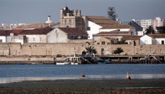
The anchorage at Faro is identifiable by the boats on moorings in the pool. Anchor in the channel clear of the moorings in 4.0 - 5.0 metres. The holding is excellent in heavy mud. There is a wooden jetty on the waterfont under the old town walls where dinghies can be left during a trip ashore.
There are also numerous well-protected anchorages inside Barreta and Culatra islands, which lie to seaward of the channels up to Faro and Olhao respectively. Other anchorages lie inside the islands of Tavira, Armona and Cabanas. For more details of anchoring in the Parque Natural da Ria Formosa follow this link: Ria Formosa in the Algarve - Portugal.
Offshore Islands and Groups
The islands of Faro, Barreta, Culatra, Armona, Tavira and Cabanas lie off the towns of Faro, Olhao and Tavira, protecting the channels leading up to them from the open sea. Depending on draft, yachts can anchor in idyllic and peaceful surroundings inside several of the islands (see below).
Yacht Repairs and Services
Marine Stores
Submit addresses and contact details of marine related businesses that are of interest to cruisers.
Repairs/Yards
Quinta do Progresso Boatyard north of the anchorage (details needed).
Fuel, Water, & Electricity
None. Bring your own.
Things to do Ashore
Tourism
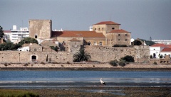
The old town of Faro is still protected on the seaward side by the 9th century Moorish walls, constructed on Roman foundations. The main square of the old town, once the Roman forum, is dominated by Faro’s 13th century cathedral (not especially interesting unless for the storks nesting in the belltower). The archaeological museum in the nearby former 16th century convent is worth a visit. The church of Nossa Senhora do Carmo contains some wonderful gilded wood carving and a chapel lined with the bones of over 1,200 monks. Near the small marina of Faro is a modest maritime museum which displays a number of interesting relics of the town’s maritime history. For lovers of the natural world, however, perhaps the area’s most enduring appeal is the Ria Formosa lagoon, a nature reserve extending to over 17,000 hectares and a haven for dozens of breeding and migratory bird species including black storks, flamingoes, little egrets and even the occasional kestrel and osprey. Otters are also regularly spotted here at quieter periods.
Grocery & Supply Stores
Provisions shops in old town.
Eateries
Internet/WiFi
No.
Laundry
Motorbike & Car Rentals
Garbage Disposal
Take it with you.
Transportation
List transportation (local and/or international.)
Routes/Passages To/From
See Portugal.
Cruiser's Friends
Contact details of "Cruiser's Friends" that can be contacted for local information or assistance.
Forum Discussions
List links to discussion threads on partnering forums. (see link for requirements)
External Links
- Faro at the Wikipedia
References & Publications
See Portugal.
Personal Notes
Personal experiences?
Last Visited & Details Checked (and updated here)
Date of member's visit to this Port/Stop & this page's details validated:
- May 2001 --Athene of Lymington 20:02, 22 March 2010 (UTC)
| This is a usable page of the cruising guide. However, please contribute if you can to help it grow further. Click on Comments to add your personal notes on this page or to discuss its contents. Alternatively, if you feel confident to edit the page, click on the edit tab at the top and enter your changes directly. |
| |
|---|
|
Names: Lighthouse, Athene of Lymington |
| Cruising Wiki Navigation
|
|---|
| | HOMEPAGE | Wiki Contents | North Atlantic | Portugal | Faro | |


