Fourni
From CruisersWiki
Istioploos (Talk | contribs) m ({{Guide2}}) |
Istioploos (Talk | contribs) (→Vitsiliá: Format) |
||
| Line 124: | Line 124: | ||
====Vitsiliá==== | ====Vitsiliá==== | ||
| - | + | {| | |
| - | Vitsiliá (Βιτσιλιά) [37° 32.6' N 26° 30.5' E] is lovely cove about 2.5 nM NE of Agridi. It affords good protection from the ''meltemi'' and the SW wind. On its head there is a small sandy beach and it is enclosed by cliffs. | + | |valign="top"|Vitsiliá (Βιτσιλιά) [37° 32.6' N 26° 30.5' E] is lovely cove about 2.5 nM NE of Agridi. It affords good protection from the ''meltemi'' and the SW wind. On its head there is a small sandy beach and it is enclosed by cliffs. |
Anchor in 5 m over sand, good holding. | Anchor in 5 m over sand, good holding. | ||
| Line 134: | Line 134: | ||
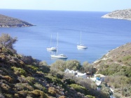
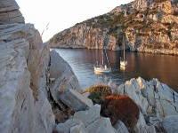
[[Image:Fourni_Vitsilia.jpg|200px|thumb|center|Anchored in Vitsiliá<br/><span style="font-size: 64%;">Curtesy Andrew & Karin Gerswell S/Y Gerswell Jenny</span><br/>''Click for larger view'']] | [[Image:Fourni_Vitsilia.jpg|200px|thumb|center|Anchored in Vitsiliá<br/><span style="font-size: 64%;">Curtesy Andrew & Karin Gerswell S/Y Gerswell Jenny</span><br/>''Click for larger view'']] | ||
| + | |||
| + | |[[Image:Fourni_Vitsilia_h_S.jpg|300px|thumb|right|Satellite view of Vitsiliá<br/>''Click for larger view'']] | ||
| + | |} | ||
====Maneta==== | ====Maneta==== | ||
Revision as of 20:38, 23 August 2008
Fourni
Click for larger view
Background
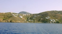
Fourni (Φούρνοι) located SW of Samos and SE of Ikaria actually consist of three islands: Fourni, Thymaina (Θύμαινα) or Fimaina, and Ayios Miνnas (Άγιος Μηνάς). They are part of the Samos prefecture.
During the 19th century and earlier they were infamous for their pirates. Today, they are inhabited by fishermen and collectively they own the largest fishing fleet in the Aegean. In the town (also called Fournoi), there are several restaurants serving seafood and lobsters at a very reasonable, by Greek standards. price.
The Fourni islands are off the beaten track and not too many cruisers visit them. Maybe the violent gusts deter them. This is a shame because these island are very indented and have many attractive coves where a yacht can anchor and enjoy the solitude.
Charts
BA 2682 Kólpos Patalion to Nísos Nísiros
BA 1537 Nisídhes Foúrnoi with the straits between Nísos Sámos and Nísos Ikaría
Imray-Tetra G32 Eastern Sporades, Dodecanese & the Coast of Turkey
NIMA 54402 Island of the Aegean - Fournoi
Greek 42 Andros to Chalki Island
Greek 422 Naxos to Samos & Opposite Coast of Asia Minor
Radio Nets
Also see World Cruiser's Nets
- Coast Guard - VHF channel 12 & Tel. +30 22750 51 207
- Olympia Radio - VHF (No signal)
- GSM/GPRS - There is no signal in Perokopió
Approaching Fourni is not hard but if you want to transit the channel between the island of Fourni and Thymaina there is Danger: With a strong meltemi the wind not only is accelerated (Venturi effect) but it is fighting the north setting current and creates rather confused seas. Under no circumstances you should transit the channel by night. Also, the very narrow channel between the small island of Diapori and Fourni is too shallow for most yachts.
Warning: The channel between Fourni and Samos is subject to very strong gusts. Usually the wind in the channel is on force point stronger than elsewhere in the neighborhood. When you transit this channel stay as far as possible from Samos with its very strong katabatic winds down Mt. Kerkis.
Ports and Popular Stops
The main harbor is in the town of Fourni and it is not a very comfortable anchorage. Near-by is the small but secure anchorage of Kampí, and there are many other attractive coves. All of Fourni, however, are subject to very violent gusts.
Fourni
Click for larger view
The harbor of Fourni (Φούρνοι) [37° 34.7' N 26° 28.8' E] or Korséi (Κορσέοι) gets a fair amount of swell with the meltemi and to compound the problem its rocky bottom with a thin layer of mud provides poor holding.
It is an attractive town and a "must see place" for anyone interested in traditional Greek wooden boats (caiques). Unfortunately an ill-conceived EU program sponsored by the EU that is aimed at reducing over fishing is destroying a centuries old maritime heritage. The program pays a substantial sum to a fisherman who retires his fishing boat, provided that the boat is destroyed. Here, in Fourni where there are many traditional caiques, the effect of this well-meaning program is to destroy many irreplaceable traditional wooden boats. Last winter, we were told by the locals, with tears in their eyes, that two beautiful trechandiria, in very good condition, were broken with a bulldozer.
Last Visited & Details Checked (and updated here)
Date of member's visit to this Port/Stop & this page's details validated:
- July 2004 --Istioploos 14:26, 26 June 2008 (MDT)
Click for larger view
Anchorages
Kampí
Click for larger view
Kampí (Καμπί) [37° 34.2' N 26° 28.6' E] is a small cove just south of the Fourni harbor. It is well protected from the meltemi. We have weathered here a force 9 gale blowing for several days. The bottom provides much better holding than Fourni harbor but it is fairly deep and care must be taken during anchoring. Allow at least 45 m of chain.
On the W shore, the proprietor of the local taverna To Kampí, has made concrete columns on the rocks for tieing a shore line. It is best to use two lines. He also (2001) has placed 3 laid moorings but in May of 2007 only one was there. These are much easier and more secure than anchoring. Please do keep in mind, however, that if you do use them you are morally obligated to eat at least one meal at his restaurant.
Care must be taken approaching the rocks with an inflatable. They are very sharp and full of sea urchins. The wind here, as in most of Fourni, has violent gusts and seems to come from every direction.
Ashore, there is a small restaurant (the owner of the moorings and columns) with wholesome home cooking and very fresh fish. There is an uphill path that connects with the road leading to the town about 30 minutes on foot.
Last Visited & Details Checked (and updated here)
Date of member's visit to this Port/Stop & this page's details validated:
- May 2007 --Istioploos 14:26, 26 June 2008 (MDT)
Pelekaniá & Elidaki
Click for larger view
Pelekaniá (Πελεκανιά) [37° 32.8' N 26° 28.7' E] to the north and Elidaki (Ελιδάκι) to the south is the first cove going south from Kampí it is also referred to in several charts as Kladharidi.
It is attractive and remote, only some nudist bathers make it here. It provides reasonable shelter from the meltemi but not as good as in Kampí.
Last Visited & Details Checked (and updated here)
Date of member's visit to this Port/Stop & this page's details validated:
- September 2001 --Istioploos 15:04, 26 June 2008 (MDT)
Perokopió
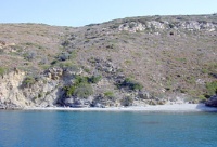
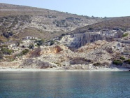
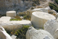
| Perokopió (Πετροκοπιό) or Marmaro (Μάρμαρο) [37° 33.6' N 26° 29.2' E] is a large and pleasant cove located 2.1 nM SE of Kampí. It provides reasonable shelter (but not as good as Kampí). On the shore there is an ancient marble quarry. Anchor in 3-6 m. Good holding.
Warning: Be careful of the submerged foundations of the ancient harbor on NW side of the cove. It is easy to visit the ancient quarry where there are a number of unfinished column drums. There is no GSM/GPRS) signal here. To make a call you must climb up the hill. Last Visited & Details Checked (and updated here)Date of member's visit to this Port/Stop & this page's details validated:
| File:Fourni Petrokopio h S.jpg Satellite view of Perokopió Click for larger view |
Ayios Ioannis
The next cove S of Perokopió is Ayios Ioannis (Άγιος Ιωάννης). There is a small village above the cove and a monastery. It looks attractive.
Kasídi
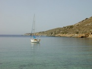
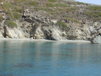
Kasídi (Κασίδι) is an isolated cove [37° 32.1' N 26° 30.1' E] is just NW of Cape Agridió and about 6 nM from Kambí. It is a lovely place with clear emerald-colored waters. It gives good protection from the meltemi but with southerlies an unpleasant swell develops.
Anchor in 4-6 m over sand. Good holding.
Last Visited & Details Checked (and updated here)
Date of member's visit to this Port/Stop & this page's details validated:
- July 2003 --Istioploos 15:04, 26 June 2008 (MDT)
Vlichada
Vlichada (Βλυχάδα) [37° 31.9' N 26° 30.3' E] is the southernmost cove in Fourni just W of Cape Agridió. It provides good shelter from the meltemi but is completely exposed to the S.
Last Visited & Details Checked (and updated here)
Date of member's visit to this Port/Stop & this page's details validated:
- July 2003 --Istioploos 15:04, 26 June 2008 (MDT)
Vitsiliá
| Vitsiliá (Βιτσιλιά) [37° 32.6' N 26° 30.5' E] is lovely cove about 2.5 nM NE of Agridi. It affords good protection from the meltemi and the SW wind. On its head there is a small sandy beach and it is enclosed by cliffs.
Anchor in 5 m over sand, good holding. Last Visited & Details Checked (and updated here)Date of member's visit to this Port/Stop & this page's details validated:
| File:Fourni Vitsilia h S.jpg Satellite view of Vitsiliá Click for larger view |
Maneta
This is a cove a few miles N of Vitsiliá. According to the locals it provides good all around shelter but it is not look very attractive and the bottom is weed. Bad holding.
Last Visited & Details Checked (and updated here)
Date of member's visit to this Port/Stop & this page's details validated:
- September 2007 --Istioploos 15:29, 26 June 2008 (MDT)
Other Coves
There are many other coves, as indicated on the map, in Thymaina or Fimaina and Ayia Triáda NE of the harbor.
Use depending on the weather.
Routes/Passages To/From
Popular passages/routes, timing, etc.
Tourism & things to do ashore
Fourni are not a "tourist's" islands. There are no major antiquities or other sites. There is the quarry in Perokopió, of course, and the town of Fourni or Korséi. It has some attractive houses, and for someone interested in traditional boats there are there although they too are getting fewer and fewer.
But, there are wonderful, isolated beeches and lovely walks early in the morning or late in the evening.
Fuel, Water, & Electricity
None of these are available.
Laundry
N/A.
Grocery & Supply Stores
- There are stores with limited supplies
- A store next to the bakery in the town of Fourni sells a very good local fresh goat cheese
Eateries
- In the Fourni there are many restaurants serving fresh seafood and lobsters (not in September) at reasonable prices
- Miltos is one of the oldest and very reliable
Internet/WiFi
N/A
Motorbike & Car Rentals
- In the town of Fourni.
Marine Stores & Facilities
Only fishing supplies.
Repairs
Woodwork and Diesel engine repairs are possible.
Transportation
- There are daily ferries to Athens, and in the summer hydrofoil service to Samos and Patmos
- There is only one taxi tel. +30 22750 51223 or +30 6977 370 471
References & Publications
See Greece.
Cruiser's Friends
Contact details of "Cruiser's Friends" that can be contacted for local information or assistance.
Forum Discussions
List links to discussion threads on the Cruiser Log Forum
External Links
- Fournoi (Wikipedia)
Personal Notes
- I am in love with Fourni --Istioploos 16:08, 26 June 2008 (MDT).
Last Visited & Details Checked (and updated here)
See individual ports in this page.
.
