Giglio
From CruisersWiki
Lighthouse (Talk | contribs) m (Text replace - "Wiki Contents" to "Wiki Contents") |
m (Text replace - "#References & Publications|" to "#References|") |
||
| (39 intermediate revisions not shown) | |||
| Line 1: | Line 1: | ||
| - | + | {{IsPartOf|Mediterranean|Italy|Tuscan Coast }} | |
| - | {| | + | {{TOC block}} |
| - | | | + | |
| - | | | + | |
| - | + | ||
| - | + | ||
| - | + | ||
| - | + | ||
| - | + | ||
| - | + | ||
| - | + | ||
| - | + | ||
| - | + | ||
| - | + | ||
| - | + | ||
| - | '''Giglio''' is a mountainous island lying 28 miles SE of [[Elba]] and just eight miles off the Argentario peninsula on the Italian mainland. Composed almost entirely of granite, it was an important source of this building material from Roman times right up to the twentieth century, and many of Rome’s most famous basilicas are constructed partly with Giglio granite. The island has one small harbour, Porto Giglio, on the eastern side of the island and a lovely old pirate-proof settlement, Castello, on its highest point. | + | {{infobox |
| + | |lat=42.354485| lon=10.901184 | ||
| + | |zoom=12 | ||
| + | |chartlet=y | ||
| + | | image= GiglioPort.jpg | ||
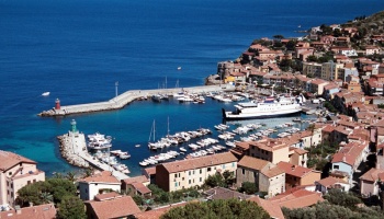
| + | | imagetext= The harbour of Porto Giglio | ||
| + | |summary='''Giglio''' is a mountainous island lying 28 miles SE of [[Elba]] and just eight miles off the Argentario peninsula on the Italian mainland. Composed almost entirely of granite, it was an important source of this building material from Roman times right up to the twentieth century, and many of Rome’s most famous basilicas are constructed partly with Giglio granite. The island has one small harbour, Porto Giglio, on the eastern side of the island and a lovely old pirate-proof settlement, Castello, on its highest point. | ||
| + | | notes= | ||
| + | | news= | ||
| + | }} | ||
==Charts== | ==Charts== | ||
| - | British Admiralty 1999 - Livorno to Civitavecchia | + | ; British Admiralty |
| - | + | : 1999 - Livorno to Civitavecchia | |
| - | + | ; Italian | |
| - | + | : 913 | |
| - | + | ||
| - | + | ||
| - | + | ||
==Weather== | ==Weather== | ||
| Line 30: | Line 23: | ||
Sources for weather forecasts: | Sources for weather forecasts: | ||
| - | * There is a continuous ( | + | * There is a continuous (computerized voice) weather forecast on VHF 68 - first in Italian and then followed with an English translation |
| - | * The same forecast is given in Italian and English on VHF coastal stations following a notification on channel 16 | + | * The same forecast is given in Italian and English on VHF coastal stations following a notification on channel 16 |
| - | * Navtex weather forecasts are broadcast from stations at Roma, Cagliari (Sardinia) and Augusta (Sicily) | + | * Navtex weather forecasts are broadcast from stations at Roma, Cagliari (Sardinia) and Augusta (Sicily) |
| - | == | + | ==Passages== |
| - | + | {{Green|List popular passages/routes, timing, etc.}} | |
| + | * | ||
| + | * | ||
| + | ==Islands== | ||
| + | [[Giannutri]] | ||
| - | == | + | ==Passages== |
| - | + | ''See [[Mediterranean#Mediterranean_Passages|Mediterranean]]''. | |
| - | == | + | ==Communication== |
| - | + | {{Green|Add here VHF channel for coastguard, harbor masters. etc.}} | |
| - | + | * | |
| + | * | ||
| - | + | ''Also see [[World MM Nets|World Cruiser's Nets]]''. | |
| - | + | ||
| - | == | + | ==Navigation== |
| - | + | The small harbour is difficult to identify when cruising along the east coast of the island. However, the settlement of Castello directly above is a good landmark. Closer in, the houses of the village and the east and west breakwaters will be seen. Beware of ferries leaving the harbour at speed. | |
| - | == | + | ==Berthing== |
| - | + | The harbour is very small and often full to bursting in high season. Unless you have reserved a berth, you will have to take pot luck on entering. You can try calling on +39 0564 809480 to reserve a berth. Otherwise, the local ''ormeggiator'' (mooring attendant) will soon let you know if there is no space. | |
| - | ==== | + | ===Ports=== |
| + | {{poi | lat= 42.36036| lon=10.9205 | ||
| + | | type= harbour | ||
| + | | name= Porto Gilio | ||
| + | | altname= | ||
| + | | zoom= 17 | ||
| + | | portofentry= | ||
| + | | image= | ||
| + | | imagetext= | ||
| + | | text= Porto Giglio is the only sheltered harbour on the island. It is very small, with only around 80 berths on three floating pontoons suitable for yachts (of which 20 are reserved for yachts in transit). Maximum length 13 metres. Maximum draught 2.5 metres. All the berths have laid moorings. Visiting yachts are directed by the ''ormeggiator'', assuming there is a berth available. Often in summer most of the berths are reserved. Water and electricity are available at the berths. | ||
| + | }} | ||
| + | |||
| + | ===Marinas & Yacht Clubs=== | ||
None. | None. | ||
| - | ==== | + | ==Anchorages== |
| - | + | {{poi | lat= 42.35163| lon=10.92229 | |
| + | | type= anchorage | ||
| + | | name=Cala delle Cannelle | ||
| + | | altname= | ||
| + | | zoom= 16 | ||
| + | | image= | ||
| + | | imagetext= | ||
| + | | text= Cala delle Cannelle, about one mile to the south of the harbour, offers reasonable shelter if the harbour is full. Anchor in sand and weed in 5.0 - 7.0 metres off the beach. | ||
| + | }} | ||
| - | == | + | {{poi | lat= 42.36706|lon=10.88078 |
| - | + | | type= anchorage | |
| + | | name=Campese | ||
| + | | altname= | ||
| + | | zoom= 16 | ||
| + | | image= | ||
| + | | imagetext= | ||
| + | | text= Campese is on the NE side of the island. | ||
| + | }} | ||
| + | |||
| + | ==Amenities== | ||
| + | {{tlist | ||
| - | + | |header|Facilities | |
| - | + | ||
| - | + | ||
| - | + | ||
| - | + | ||
| - | + | ||
| - | + | ||
| - | + | ||
| - | + | ||
| - | + | |Water| Water on the pontoons | |
| - | + | |Electricity| Electricity on the pontoons | |
| + | |Toilets| {{MagentaText|?}} | ||
| + | |Showers| {{MagentaText|?}} | ||
| + | |Laundry| {{MagentaText|?}} | ||
| + | |Garbage| Bins near the quay | ||
| - | + | |header|Supplies | |
| - | + | |Fuel| Fuel available on the quay in summer (0800 - 1900) | |
| + | |Bottled gas| {{MagentaText|?}} | ||
| + | |Chandlers| None | ||
| - | + | |header|Services | |
| - | ?? | + | |Repairs| Limited engine and electrical repairs |
| + | |Internet| {{MagentaText|?}} | ||
| + | |Mobile connectivity| {{MagentaText|?}} | ||
| + | |Vehicle rentals| {{MagentaText|?}} | ||
| + | }} | ||
| - | == | + | ==Provisioning== |
| - | + | Reasonable provisions around the harbour. | |
| - | == | + | ==Eating out== |
| - | + | Lots of restaurants and cafes around the [[#Porto Gilio|harbour]]. A few also in [[#Campese|Campese]]. | |
| - | == | + | ==Transportation== |
| - | + | Ferries to and from [[Porto Santo Stefano]] on the mainland. | |
| - | == | + | ==Tourism== |
| - | + | The port area is most attractive and very well kept. There is evidence of a lot of municipal pride here. The excellent trip by bus to the fortified village of Castello at the top of the island is a must. The village has intact town walls and the original mediaeval street plan survives inside – all winding alleyways and steep passages with overhead arches. At the north end is a wonderful restaurant with views over the north of the island. It is possible to walk back down to the harbour along an old mule track, with spectacular views over the port and the Italian mainland just eight miles away. | |
| - | + | {{hgallery| | |
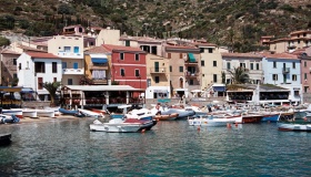
| - | + | {{himage|GiglioWaterfront.jpg|The waterfront of Porto Giglio}} | |
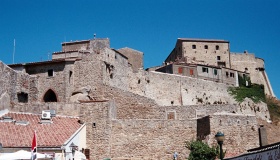
| - | + | {{himage|GiglioCastello.jpg|The fortified village of Castello}} | |
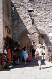
| + | {{himage|GiglioCastelloStreet.jpg|Castello street scene}} | ||
| + | {{himage|GiglioMule.jpg|The mule track from Castello}} | ||
| + | }} | ||
| - | == | + | ==Friends== |
Contact details of "Cruiser's Friends" that can be contacted for local information or assistance. | Contact details of "Cruiser's Friends" that can be contacted for local information or assistance. | ||
* | * | ||
| - | + | ==Forums== | |
| - | == | + | List links to discussion threads on [[Cruising Forums|partnering forums]]. (''see link for requirements'') |
| - | List links to | + | |
| - | + | ||
| - | + | ||
| - | + | ||
| - | + | ||
| - | + | ||
| - | + | ||
| - | + | ||
| - | + | ||
| - | + | ||
| - | + | ||
| - | + | ||
| - | '' | + | |
| - | + | ||
* | * | ||
| - | == | + | ==Links== |
| - | + | * {{wikipedia|Isola_del_Giglio}} | |
| - | * | + | * {{Wikivoyage}} |
| + | * n | ||
| + | ==References== | ||
| + | ''See [[Italy#References|Italy]]''. | ||
| - | {{ | + | {{Comments}} |
| + | * | ||
| + | |||
| + | {{Verified by}} | ||
| + | * July 2003 --[[User:Atheneoflymington|Athene of Lymington]] 16:02, 5 August 2010 (UTC) | ||
| + | * May, 2013. The salvage work on the Costa Concordia has turned the Giglio harbor into a bustling commercial port. Most of the berths available for yachts have been taken over by work boats which tie to the quay. Be aware that while this activity is going on, you will be lucky to find space on the quay, and that if you do, you will likely be mooring the old fashioned way - stern to with an anchor off the bow. | ||
| + | {{Page useable}} | ||
| - | |||
| - | |||
| - | |||
| - | |||
| - | |||
| + | {{Contributors|[[User:Atheneoflymington|Athene of Lymington]]}} | ||
| - | + | [[Category:Islands - Italy]] [[Category:Ports - Italy]] [[Category:Anchorages - Italy]] | |
Latest revision as of 07:45, 21 August 2018
| Giglio
| |
| | |
Giglio is a mountainous island lying 28 miles SE of Elba and just eight miles off the Argentario peninsula on the Italian mainland. Composed almost entirely of granite, it was an important source of this building material from Roman times right up to the twentieth century, and many of Rome’s most famous basilicas are constructed partly with Giglio granite. The island has one small harbour, Porto Giglio, on the eastern side of the island and a lovely old pirate-proof settlement, Castello, on its highest point.
Charts
- British Admiralty
- 1999 - Livorno to Civitavecchia
- Italian
- 913
Weather
Prevailing winds are from W or NW, in which conditions shelter is reasonably good in the island’s harbour. However, strong northerly winds send in a very uncomfortable swell and the harbour is only just tenable in these conditions.
Sources for weather forecasts:
- There is a continuous (computerized voice) weather forecast on VHF 68 - first in Italian and then followed with an English translation
- The same forecast is given in Italian and English on VHF coastal stations following a notification on channel 16
- Navtex weather forecasts are broadcast from stations at Roma, Cagliari (Sardinia) and Augusta (Sicily)
Passages
List popular passages/routes, timing, etc.
Islands
Passages
See Mediterranean.
Communication
Add here VHF channel for coastguard, harbor masters. etc.
Also see World Cruiser's Nets.
The small harbour is difficult to identify when cruising along the east coast of the island. However, the settlement of Castello directly above is a good landmark. Closer in, the houses of the village and the east and west breakwaters will be seen. Beware of ferries leaving the harbour at speed.
Berthing
The harbour is very small and often full to bursting in high season. Unless you have reserved a berth, you will have to take pot luck on entering. You can try calling on +39 0564 809480 to reserve a berth. Otherwise, the local ormeggiator (mooring attendant) will soon let you know if there is no space.
Ports
Porto Gilio
Marinas & Yacht Clubs
None.
Anchorages
Cala delle Cannelle
Campese
Amenities
| Facilities | |
|---|---|
| Water | Water on the pontoons |
| Electricity | Electricity on the pontoons |
| Toilets | ? |
| Showers | ? |
| Laundry | ? |
| Garbage | Bins near the quay |
| Supplies | |
| Fuel | Fuel available on the quay in summer (0800 - 1900) |
| Bottled gas | ? |
| Chandlers | None |
| Services | |
| Repairs | Limited engine and electrical repairs |
| Internet | ? |
| Mobile connectivity | ? |
| Vehicle rentals | ? |
Provisioning
Reasonable provisions around the harbour.
Eating out
Lots of restaurants and cafes around the harbour. A few also in Campese.
Transportation
Ferries to and from Porto Santo Stefano on the mainland.
Tourism
The port area is most attractive and very well kept. There is evidence of a lot of municipal pride here. The excellent trip by bus to the fortified village of Castello at the top of the island is a must. The village has intact town walls and the original mediaeval street plan survives inside – all winding alleyways and steep passages with overhead arches. At the north end is a wonderful restaurant with views over the north of the island. It is possible to walk back down to the harbour along an old mule track, with spectacular views over the port and the Italian mainland just eight miles away.
Friends
Contact details of "Cruiser's Friends" that can be contacted for local information or assistance.
Forums
List links to discussion threads on partnering forums. (see link for requirements)
Links
References
See Italy.
Comments
We welcome users' contributions to the Wiki. Please click on Comments to view other users' comments, add your own personal experiences or recommend any changes to this page following your visit.
Verified by
Date of member's last visit to Giglio and this page's details validated:
- July 2003 --Athene of Lymington 16:02, 5 August 2010 (UTC)
- May, 2013. The salvage work on the Costa Concordia has turned the Giglio harbor into a bustling commercial port. Most of the berths available for yachts have been taken over by work boats which tie to the quay. Be aware that while this activity is going on, you will be lucky to find space on the quay, and that if you do, you will likely be mooring the old fashioned way - stern to with an anchor off the bow.
| This is a usable page of the cruising guide. However, please contribute if you can to help it grow further. Click on Comments to add your personal notes on this page or to discuss its contents. Alternatively, if you feel confident to edit the page, click on the edit tab at the top and enter your changes directly. |
| |
|---|
|
Names: Athene of Lymington |
