Gulf of Evia
From CruisersWiki
m (bot: Personal Notes) |
m (Text replace - "==References & Publications==" to "==References==") |
||
| (17 intermediate revisions not shown) | |||
| Line 1: | Line 1: | ||
{{IsPartOf|Mediterranean|Aegean Sea|Greece}} | {{IsPartOf|Mediterranean|Aegean Sea|Greece}} | ||
| - | + | {{Page imagemap|clear=y}} | |
| - | + | ||
| - | + | ||
| - | + | ||
| - | + | ||
| - | + | ||
| - | + | ||
| - | + | ||
| - | + | ||
| - | + | ||
| - | + | ||
| - | + | ||
{{TOC block}} | {{TOC block}} | ||
| - | |||
| - | |||
| - | |||
| - | |||
The Gulf of [http://en.wikipedia.org/wiki/Euboea Evia], that is the gulf between the large island of Evia and mainland Greece, is not a popular cruising ground. The waters of this gulf tend to be less clear than the Aegean and there is a sizable industrial development along the southern mainland. However, many yachts choose to transit the more protected gulf on their way from the Athens region to the Sporades islands instead of braving the notorious Kafireas Stait with is strong northerly winds. | The Gulf of [http://en.wikipedia.org/wiki/Euboea Evia], that is the gulf between the large island of Evia and mainland Greece, is not a popular cruising ground. The waters of this gulf tend to be less clear than the Aegean and there is a sizable industrial development along the southern mainland. However, many yachts choose to transit the more protected gulf on their way from the Athens region to the Sporades islands instead of braving the notorious Kafireas Stait with is strong northerly winds. | ||
| Line 36: | Line 21: | ||
: 421 Karystos to Naxos | : 421 Karystos to Naxos | ||
| - | == | + | ==Weather== |
| + | ''See [[Aegean Sea#Weather and Winds|Aegean Sea]]''. | ||
| + | |||
| + | ==Passages== | ||
| + | * [[Passages between Athens Region and Samos - Kusadasi]] | ||
| + | * [[Passages between Athens Region and the North Sporades]] | ||
| + | |||
| + | ==Islands== | ||
| + | {{Poi |lat=38.00523 |lon=24.26193 | type= island |name= Petalii |altname= Πεταλιοί |zoom= 13 | ||
| + | | image= Greece_PetaliiVasiliko.jpg | ||
| + | | imagetext= The Anchorage of Vasiliko in Petalii | ||
| + | | text= There are several coves in the small islands of Petalii near [[#Karistos|Karistos]]. }} | ||
| + | |||
| + | {{Poi |37|58.9|N|24|15.2|E| | type= island |name= Vasiliko |altname= Βασιλικό |zoom= 15 | ||
| + | | text= Vasiliko is well protected from the ''meltemi'' and is very pleasant. It is at the southern side of Pelalii. Anchor in sand at about 4.5 m, good holding. }} | ||
| + | |||
| + | {{hold vertical}} | ||
| + | |||
| + | {{Poi |38|40.3|N|23|05.3|E|| type= island |name= Ormos Atalantis |zoom= 15 | ||
| + | | image= Greece_Evia_Atalanti_m.jpg | ||
| + | | imagetext= Chart of Atalanti Island | ||
| + | | text= The cove is on the SW side of the island [http://www.maicar.com/GML/Atalanta.html Atalanti], about 30 nM NW of [[#Halkis|Halkis]] and near the mainland. The island is deserted and it is used as a bird sanctuary. It is a very pleasant anchorage. | ||
| + | |||
| + | You can easily reach by dinghy the small harbor in the mainland, Skala Atalantis, less than a mile from the island. | ||
| + | |||
| + | This anchorage is in the {{mark |lat=38.67127 |lon=23.0767 | type= anchorage |name= Ormos Amirou | zoom= 16}} just off the beach. There is a cafe and tavernas ashore.}} | ||
| + | |||
| + | ==Communication== | ||
* Goast Guard - VHF channel 12 tel. +30 22210 28888 (Halkis) | * Goast Guard - VHF channel 12 tel. +30 22210 28888 (Halkis) | ||
''Also see [[World MM Nets|World Cruiser's Nets]]''. | ''Also see [[World MM Nets|World Cruiser's Nets]]''. | ||
| - | == | + | ==Navigation== |
| - | + | ||
| - | + | ||
| - | + | ||
Approached to the gulf are straightforward. The trickiest part is transiting the Euripus Channel with its low bridge and strong tidal current which can reach 6-7 knots. | Approached to the gulf are straightforward. The trickiest part is transiting the Euripus Channel with its low bridge and strong tidal current which can reach 6-7 knots. | ||
| - | ==Berthing | + | ==Berthing== |
The major port in the Gulf of Evia is Halkis. | The major port in the Gulf of Evia is Halkis. | ||
===Ports=== | ===Ports=== | ||
| - | + | {{Poi |38|27.7|N|23|35.3|E| | type= harbour |name= Halkis |altname= Χαλκίς |zoom= 15 | |
| - | {{ | + | |
| - | | name= Halkis | + | |
| - | | zoom= 15 | + | |
| image= Greece_Evia_Halkis_h.jpg | | image= Greece_Evia_Halkis_h.jpg | ||
| imagetext=Chart of Halkis Channel | | imagetext=Chart of Halkis Channel | ||
| - | + | | text= [http://en.wikipedia.org/wiki/Chalkis Halkis] or Chalkis or Khalkis is the capital of Evia. It is a bustling and fairly pleasant place. Good shopping for provisions, chandlery and gas. | |
| - | [http://en.wikipedia.org/wiki/Chalkis Halkis] | + | |
A yacht travelling north can wait for the bridge to open moored side-to (alongside) by the customs house on the SE side of the channel or in the marina 38 27.466N, 023 35.444E which is operated by the local authority and welcomes visiting yachts transiting the bridge. Alternatively anchor off in the anchorage just south-west of the bridge keeping clear of the tidal streams. | A yacht travelling north can wait for the bridge to open moored side-to (alongside) by the customs house on the SE side of the channel or in the marina 38 27.466N, 023 35.444E which is operated by the local authority and welcomes visiting yachts transiting the bridge. Alternatively anchor off in the anchorage just south-west of the bridge keeping clear of the tidal streams. | ||
| - | Travelling south yachts normally moor alongside the NE town quay (take care to allow for the tide when mooring alongside). | + | Travelling south yachts normally moor alongside the NE town quay (take care to allow for the tide when mooring alongside). }} |
=====Halkis Bridge===== | =====Halkis Bridge===== | ||
| Line 71: | Line 76: | ||
You must visit the Port Police (''Limenarchio'') at the new office (which is now on the Halkis town side (east) of the bridge) in advance to book a passage through the bridge. Then they will then contact you on VHF Channel 12 in the evening to check you are ready and again to call you to start the transit through the bridge. | You must visit the Port Police (''Limenarchio'') at the new office (which is now on the Halkis town side (east) of the bridge) in advance to book a passage through the bridge. Then they will then contact you on VHF Channel 12 in the evening to check you are ready and again to call you to start the transit through the bridge. | ||
| - | + | {{hgallery| | |
| - | + | {{himage|Khalkis_marina_1.jpg|Halkis marina}} | |
| - | + | {{himage|Khalkis_town_quay_1.jpg|Halkis town quay}} | |
| - | + | }} | |
| - | + | ||
| - | + | ||
| - | + | ||
| - | + | ||
| - | + | ||
| - | + | ||
| - | + | ||
| - | + | {{Poi |38|0.7|N|24|25|E| | type= harbour |name= Karistos |altname= Κάρυστος) |zoom= 17 | |
| - | {{ | + | |
| - | | name= Karistos | + | |
| - | | zoom= 17 | + | |
| image= Greece_Evia_Karystos_h.jpg | | image= Greece_Evia_Karystos_h.jpg | ||
| imagetext= Chart of Karistos Harbor | | imagetext= Chart of Karistos Harbor | ||
| - | + | | text= [http://en.wikipedia.org/wiki/Karystos Karistos] or Karystos is a large, mostly commercial, harbor in S Evia. While the harbor is large finding room is another mater all together. Also, the ''Limenarchio'' (Coast Guard) is very vigilant and liable to overcharge you. | |
| - | [http://en.wikipedia.org/wiki/Karystos Karistos] or Karystos | + | |
This is a good place to wait a good weather window when you are going N on the infamous Kafireas Strait. | This is a good place to wait a good weather window when you are going N on the infamous Kafireas Strait. | ||
| Line 98: | Line 92: | ||
With the prevailing during the during the summer ''meltemi'' winds you can anchor off E of the harbor in front of the small fort. Anchor in 6 m depth over sand. Good holding. | With the prevailing during the during the summer ''meltemi'' winds you can anchor off E of the harbor in front of the small fort. Anchor in 6 m depth over sand. Good holding. | ||
| - | {{Caution}}There can be violent gusts and katabatic winds into the bay, especially when the N wind is blowing hard. | + | {{Caution}}There can be violent gusts and katabatic winds into the bay, especially when the N wind is blowing hard. }} |
| - | + | {{hgallery| | |
| - | + | {{himage|Evia_Karystos.jpg|The Esplanade in Karistos}} | |
| - | + | {{himage|Greece_Karistos.jpg|The Fort of Karistos}} | |
| - | + | }} | |
| - | + | ||
| - | + | ||
| - | + | ||
| - | + | ||
| - | + | ||
==Marinas & Yacht Clubs== | ==Marinas & Yacht Clubs== | ||
[[#Halkis|Halkis]] marina is now (2013) run by the local authority. The yacht club is adjacent to it. | [[#Halkis|Halkis]] marina is now (2013) run by the local authority. The yacht club is adjacent to it. | ||
| - | + | ==Anchorages== | |
| - | + | {{Poi |38|18|N|24|07|E| | type= anchorage |name= Voufalo |altname= Βούφαλο |zoom= 16 | |
| - | {{ | + | |
| - | | name= Voufalo | + | |
| - | | zoom= 16 | + | |
| image= Greece_Evia_Voufalo_h.jpg | | image= Greece_Evia_Voufalo_h.jpg | ||
| imagetext= Chart of Voufalo | | imagetext= Chart of Voufalo | ||
| - | + | | text= There is an attractive looking cove on the SE of the island. }} | |
| - | + | ||
| - | |||
| - | |||
| - | |||
| - | |||
{{hold vertical}} | {{hold vertical}} | ||
| - | + | {{Poi |37|58.5|N|24|32.4|E| | type= anchorage |name= Kastri |altname= Καστρί |zoom= 16 | |
| - | {{ | + | |
| - | | name= Kastri | + | |
| - | | zoom= 16 | + | |
| image= Greece_KastriEvia.jpg | | image= Greece_KastriEvia.jpg | ||
| imagetext= The Anchorage of Kastri | | imagetext= The Anchorage of Kastri | ||
| - | + | | text= Kastri is a pleasant anchorage on the Evia side of the Kafireas channel. It is well protected from the ''meltemi'' but with strong winds there can develop an uncomfortable swell in the cove, there can also be some rather strong gusts. }} | |
| - | Kastri is a pleasant anchorage on the Evia side of the Kafireas channel. It is well protected from the ''meltemi'' but with strong winds there can develop an uncomfortable swell in the cove, there can also be some rather strong gusts. | + | |
| - | |||
| - | |||
| - | |||
| - | |||
| - | |||
| - | == | + | ==Amenities== |
| - | + | {{tlist | |
| - | {{ | + | |
| - | + | ||
| - | + | ||
| - | + | ||
| - | + | ||
| - | + | ||
| - | + | ||
| - | + | |header|Facilities | |
| - | + | ||
| - | + | |Water| | |
| - | + | * [[#Halkis|Halkis]]: on the N town quay and in the marina | |
| - | * | + | * [[#Karistos|Karistos]]: on the quay |
| - | + | ||
| - | + | ||
| - | + | |Electricity| | |
| - | + | * [[#Halkis|Halkis]]: on the N town quay and in the marina | |
| - | | | + | * [[#Karistos|Karistos]]: N/A (Not Available) (posts have been installed but are not operational) |
| - | + | ||
| - | + | ||
| - | + | ||
| - | + | ||
| - | + | ||
| - | + | |Toilets| {{MagentaText|?}} | |
| + | |Showers| {{MagentaText|?}} | ||
| + | |Laundry| In [[#Halkis|Halkis]] and in [[#Karistos|Karystos]] | ||
| + | |Garbage| There are bins in the ports and in some of the anchorages | ||
| - | + | |header|Supplies | |
| - | + | |Fuel| | |
| + | * [[#Halkis|Halkis]]: you can get from either a gas station or arrange for a delivery by a truck | ||
| + | * [[#Karistos|Karistos]]: from gas stations, you will have to carry jerry cans. You may be able to arrange for a delivery by a mini tank | ||
| - | + | |Bottled gas| In supermarkets | |
| - | + | |Chandlers| Only fishing supplies | |
| - | + | ||
| - | + | ||
| - | + | |header|Services | |
| - | + | |Repairs| N/A | |
| - | + | |Internet| In internet cafés | |
| + | |Mobile connectivity| In general stron 3G and in places 4G signal | ||
| + | |Vehicle rentals| | ||
| + | * In the town of [[#Halkis|Halkis]] | ||
| + | * Several agencies in [[#Karistos| Karistos]] | ||
| + | }} | ||
| - | == | + | ==Provisioning== |
| - | + | ||
| - | + | ||
| - | + | ||
| - | + | ||
| - | + | ||
| - | + | ||
| - | + | ||
| - | + | ||
| - | + | ||
| - | + | ||
| - | + | ||
| - | + | ||
| - | + | ||
| - | + | ||
| - | + | ||
| - | + | ||
| - | + | ||
| - | + | ||
* There is very good food shopping in [[#Halkis|Halkis]] | * There is very good food shopping in [[#Halkis|Halkis]] | ||
* Good stores in [[#Karistos|Karistos]] | * Good stores in [[#Karistos|Karistos]] | ||
| - | == | + | ==Eating out== |
* You can have very good seafood on the N town quay of [[#Halkis|Halkis]] | * You can have very good seafood on the N town quay of [[#Halkis|Halkis]] | ||
* In [[#Karistos|Karistos]] there are many tavernas. Good ''loukoumades'' (honey fritters) at ''Jimmy's'' and good food at the ''Marinos'' | * In [[#Karistos|Karistos]] there are many tavernas. Good ''loukoumades'' (honey fritters) at ''Jimmy's'' and good food at the ''Marinos'' | ||
| Line 214: | Line 161: | ||
* There is a taverna in Skala Atalantis (see [[#Ormos Atalantis|Ormos Atalantis]]) | * There is a taverna in Skala Atalantis (see [[#Ormos Atalantis|Ormos Atalantis]]) | ||
| - | + | ==Transportation== | |
| - | + | ||
| - | + | ||
| - | + | ||
| - | + | ||
| - | + | ||
| - | + | ||
| - | + | ||
| - | + | ||
| - | + | ||
| - | + | ||
| - | + | ||
| - | + | ||
| - | + | ||
* There are daily busses and trains to Athens from [[#Halkis|Halkis]] | * There are daily busses and trains to Athens from [[#Halkis|Halkis]] | ||
* There are daily ferries from [[#Karistos| Karistos]] to Rafina | * There are daily ferries from [[#Karistos| Karistos]] to Rafina | ||
| - | == | + | ==Tourism== |
| - | + | {{GreenText|List places of interest, tours, etc.}} | |
| - | + | ||
| - | == | + | ==Friends== |
Contact details of "Cruiser's Friends" that can be contacted for local information or assistance. | Contact details of "Cruiser's Friends" that can be contacted for local information or assistance. | ||
* | * | ||
| - | == | + | ==Forums== |
List links to discussion threads on [[Cruising Forums|partnering forums]]. (''see link for requirements'') | List links to discussion threads on [[Cruising Forums|partnering forums]]. (''see link for requirements'') | ||
* | * | ||
* | * | ||
| - | == | + | ==Links== |
| - | * | + | * {{wikipedia|Euboea|Evia]}} |
| - | * | + | * {{Wikivoyage|Euboea| Evia}} |
| + | * {{wikipedia|Chalkis|Halkis}} | ||
| + | * {{Wikivoyage|Chalcis| Halkis}} | ||
* [http://olne.gr/en/ Evia Port Authority website] | * [http://olne.gr/en/ Evia Port Authority website] | ||
| - | * | + | * {{wikipedia|Euripus_Strait|Euripus Channel}} |
| - | * | + | * {{wikipedia|Karystos|Karistos}} |
| + | |||
* | * | ||
| - | ==References | + | ==References== |
''See [[Greece#References_&_Publications|Greece]]''. | ''See [[Greece#References_&_Publications|Greece]]''. | ||
{{Comments}} | {{Comments}} | ||
| - | |||
* | * | ||
| - | + | {{Verified by}} | |
| - | + | * 1986 ([[#Halkis Bridge|Halkis Bridge]], [[#Voufalo|Voufalo]], [[#Ormos Atalantis|Ormos Atalantis]]) {{Istioploos2}} | |
| + | * May 2009 ([[#Vasiliko|Vasiliko]]) --[[User:Istioploos|Istioploos]] | ||
| + | * August 2011 ([[#Karistos|Karistos]], [[#Kastri|Kastri]]) --[[User:Istioploos|Istioploos]] | ||
| + | * 2013 ([[#Halkis Bridge|Halkis Bridge]], [[#Ormos Atalantis|Ormos Atalantis]]) --[[User:Vigdis|Vigdis]] [[File:Sailboat favicon.png]] [http://yachtvigdis.wordpress.com yachtvigdis blog] | ||
| + | * 2013 ([[#Halkis Bridge|Halkis Bridge]]) --[[User:Antoniofj|Antoniofj]] Vourkary Cove is now a marina with floating pontoons and mooring lines. If you plan to cross the bridge to the north, is a good place to stop and pay the toll. A day's stay is free. Currently (2013) the toll payment office is on the eastern side of the bridge. | ||
| + | * 2015 ([[#Halkis Bridge|Halkis Bridge]]) --[[User:Lady Marie D|Lady Marie D]] Moored alongside just by the toll payment office (just S of the bridge on the E side - yachts moor on the red painted part of the quay) | ||
| + | * | ||
| Line 268: | Line 209: | ||
{{Contributors|[[User:Istioploos|Istioploos]], [[User:Lighthouse|Lighthouse]]}} | {{Contributors|[[User:Istioploos|Istioploos]], [[User:Lighthouse|Lighthouse]]}} | ||
| - | [[Category:Regions | + | [[Category:Regions - Greece]] |
Latest revision as of 11:53, 15 August 2018
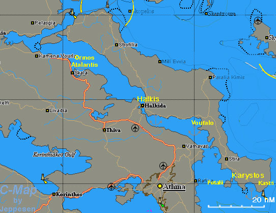

The Gulf of Evia, that is the gulf between the large island of Evia and mainland Greece, is not a popular cruising ground. The waters of this gulf tend to be less clear than the Aegean and there is a sizable industrial development along the southern mainland. However, many yachts choose to transit the more protected gulf on their way from the Athens region to the Sporades islands instead of braving the notorious Kafireas Stait with is strong northerly winds.
Charts
- BA
- 1038 Stenó Sífnou to Stenó Kafiréa
- 1085 Kólpos Petalión to Srimonikos kólpos
- 1554 Nótios Evoïkós
- 1556 Vórios Evoïkós Kólpos and approaches to Vólos
- Imray-Tetra
- G26 Nisos Evvoia
- NIMA
- 54340 Nisos Spetsai to Nisos Vorioi Sporadhes
- 54348 Vorios Evoikos Kolpos and Notios Evoikos Kolpos
- Greek
- 41 Cavos Maleas to Cavos Kimis
- 74 Corinth to Skopelos Island
- 421 Karystos to Naxos
Weather
See Aegean Sea.
Passages
- Passages between Athens Region and Samos - Kusadasi
- Passages between Athens Region and the North Sporades
Islands

Petalii
Vasiliko

Ormos Atalantis
The cove is on the SW side of the island Atalanti, about 30 nM NW of Halkis and near the mainland. The island is deserted and it is used as a bird sanctuary. It is a very pleasant anchorage.
You can easily reach by dinghy the small harbor in the mainland, Skala Atalantis, less than a mile from the island.
This anchorage is in theCommunication
- Goast Guard - VHF channel 12 tel. +30 22210 28888 (Halkis)
Also see World Cruiser's Nets.
Approached to the gulf are straightforward. The trickiest part is transiting the Euripus Channel with its low bridge and strong tidal current which can reach 6-7 knots.
Berthing
The major port in the Gulf of Evia is Halkis.
Ports

Halkis
Halkis or Chalkis or Khalkis is the capital of Evia. It is a bustling and fairly pleasant place. Good shopping for provisions, chandlery and gas.
A yacht travelling north can wait for the bridge to open moored side-to (alongside) by the customs house on the SE side of the channel or in the marina 38 27.466N, 023 35.444E which is operated by the local authority and welcomes visiting yachts transiting the bridge. Alternatively anchor off in the anchorage just south-west of the bridge keeping clear of the tidal streams.
Travelling south yachts normally moor alongside the NE town quay (take care to allow for the tide when mooring alongside).Halkis Bridge
Since the opening of the new high bridge, the old bridge which spans the 39 m wide channel Euripus Channel no longer carries all the traffic into Evia. However it is still very busy and only opens to allow water-borne traffic to pass through late at night or early morning and when the tidal stream, which can be as high as 7 knots is at a low point. Boats wanting to pass through the channel may have to wait until there are several boats waiting to transit, sometimes for up to 2 days for it to open.
Opening times can be found on the Evia Port Authority website. The information in Heikell - that the bridge does not open on Friday - is incorrect nowadays.
You must visit the Port Police (Limenarchio) at the new office (which is now on the Halkis town side (east) of the bridge) in advance to book a passage through the bridge. Then they will then contact you on VHF Channel 12 in the evening to check you are ready and again to call you to start the transit through the bridge.


Karistos
Karistos or Karystos is a large, mostly commercial, harbor in S Evia. While the harbor is large finding room is another mater all together. Also, the Limenarchio (Coast Guard) is very vigilant and liable to overcharge you.
This is a good place to wait a good weather window when you are going N on the infamous Kafireas Strait.
The inner basin of the harbor is an excellent all-around shelter. Anchor in the inner basin and moor stern-to. The bottom is mud and it provides good holding.
With the prevailing during the during the summer meltemi winds you can anchor off E of the harbor in front of the small fort. Anchor in 6 m depth over sand. Good holding.
Caution: There can be violent gusts and katabatic winds into the bay, especially when the N wind is blowing hard.

Marinas & Yacht Clubs
Halkis marina is now (2013) run by the local authority. The yacht club is adjacent to it.
Anchorages

Voufalo

Kastri
Amenities
| Facilities | |
|---|---|
| Water | |
| Electricity | |
| Toilets | ? |
| Showers | ? |
| Laundry | In Halkis and in Karystos |
| Garbage | There are bins in the ports and in some of the anchorages |
| Supplies | |
| Fuel | |
| Bottled gas | In supermarkets |
| Chandlers | Only fishing supplies |
| Services | |
| Repairs | N/A |
| Internet | In internet cafés |
| Mobile connectivity | In general stron 3G and in places 4G signal |
| Vehicle rentals | |
Provisioning
Eating out
- You can have very good seafood on the N town quay of Halkis
- In Karistos there are many tavernas. Good loukoumades (honey fritters) at Jimmy's and good food at the Marinos
- Also in Karistos the Gevsiplous (Γευσήπλους) serves an amazing variety of excellent and unusual mezedes (tasty snacks)
- There is a taverna in Skala Atalantis (see Ormos Atalantis)
Transportation
- There are daily busses and trains to Athens from Halkis
- There are daily ferries from Karistos to Rafina
Tourism
List places of interest, tours, etc.
Friends
Contact details of "Cruiser's Friends" that can be contacted for local information or assistance.
Forums
List links to discussion threads on partnering forums. (see link for requirements)
Links
- Evia] at the Wikipedia
- Evia at the Wikivoyage
- Halkis at the Wikipedia
- Halkis at the Wikivoyage
- Evia Port Authority website
- Euripus Channel at the Wikipedia
- Karistos at the Wikipedia
References
See Greece.
Comments
We welcome users' contributions to the Wiki. Please click on Comments to view other users' comments, add your own personal experiences or recommend any changes to this page following your visit.
Verified by
Date of member's last visit to Gulf of Evia and this page's details validated:
- 1986 (Halkis Bridge, Voufalo, Ormos Atalantis) --Istioploos

 Travels with S/Y Thetis
- May 2009 (Vasiliko) --Istioploos
- August 2011 (Karistos, Kastri) --Istioploos
- 2013 (Halkis Bridge, Ormos Atalantis) --Vigdis yachtvigdis blog
- 2013 (Halkis Bridge) --Antoniofj Vourkary Cove is now a marina with floating pontoons and mooring lines. If you plan to cross the bridge to the north, is a good place to stop and pay the toll. A day's stay is free. Currently (2013) the toll payment office is on the eastern side of the bridge.
- 2015 (Halkis Bridge) --Lady Marie D Moored alongside just by the toll payment office (just S of the bridge on the E side - yachts moor on the red painted part of the quay)
| This is a usable page of the cruising guide. However, please contribute if you can to help it grow further. Click on Comments to add your personal notes on this page or to discuss its contents. Alternatively, if you feel confident to edit the page, click on the edit tab at the top and enter your changes directly. |
| |
|---|
|
Names: Istioploos, Lighthouse |