Hout Bay
From CruisersWiki
m (bot: Personal Notes) |
m (bot: Extra Line) |
||
| Line 83: | Line 83: | ||
{{Page outline}} | {{Page outline}} | ||
| + | |||
{{Contributors|[[User:Lighthouse|Lighthouse]]}} | {{Contributors|[[User:Lighthouse|Lighthouse]]}} | ||
[[Category:Ports - South Africa]] | [[Category:Ports - South Africa]] | ||
Revision as of 21:33, 23 April 2016
| Hout Bay
| |
Background
Historic details & submit details about the sailing in the area, etc.
Charts
- Hout Bay - S.A.N 1015
Radio Nets
Also see World Cruiser's Nets
- SA Maritime Net: The South African Maritime Net operates 7 days a week, and provides weather reports from around the coast, and maintains contact with boats off the coast of South Africa and up into the Mozambique channel. There are two regular schedule times as follows:
- 06:30 UTC: Starts on 14316 kHz for 5-10 minutes, and then moves to 7,120 kHz.
- 11:30 UTC: Starts on 14316 kHz for approx. 30 mins and then moves down to 7,120 kHz.
Routes to/from
Popular routes, timing, etc.
Approach
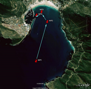
The following waypoints should be used (as a guide only) in the approach to Hout Bay Harbour:
-
 wp1 [[Hout Bay#wp1|wp1]] 34°04.106′S, 18°21.016′E (entrance to the bay)
-
 wp2 [[Hout Bay#wp2|wp2]] 34°03.207′S, 18°21.332′E
-
 wp3 [[Hout Bay#wp3|wp3]] 34°02.973′S, 18°21.198′E
-
 wp4 [[Hout Bay#wp4|wp4]] 34°03.070′S, 18°20.983′E (harbour entrance)
Dangers:
- Vessels approaching from the North should give the mainland a wide berth past "Oude Schip" as there are many submerged rocks in that area.
- Vessels approaching from the South should give Kommetjie a wide berth due to large waves in that area at times.
- All Vessels should note the presence of Vulcan Rock (34|03.967|S|18|18.582|E), a large semi-submerged rock that can not always be seen in the Northern approach.
Check-in facilities
Submit details about facilities for checking in.
Marinas/Yacht Clubs
Anchorages
List details of all safe anchorages in the area.
Tourism & things to do ashore
List places of interest, tours, eateries, etc.
Marine stores
Submit addresses and contact details of marine related businesses that are of interest to cruisers.
Offshore Islands
List Islands
References & Publications
Publications, Guides, etc.
Cruiser's Friends
Contact details of "Cruiser's Friends" that can be contacted for local information or assistance.
Forum Discussions
List links to discussion threads on partnering forums. (see link for requirements)
External Links
Links to relevant websites.
Comments
We welcome users' contributions to the Wiki. Please click on Comments to view other users' comments, add your own personal experiences or recommend any changes to this page following your visit.=
| This page has an outline in place but needs completing. Please contribute if you can to help it grow further. Click on Comments to suggest further content or alternatively, if you feel confident to edit this page, click on the edit tab at the top and enter your changes directly. |
| |
|---|
|
Names: Lighthouse |


