Komiža
From CruisersWiki
| Komiža
| |
| | |
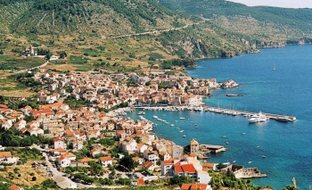
The harbour of Komiža sits at the NE end of a wide bay on the W coast of the island of Vis in Croatia, overlooked by the 600 metre high mountain of Hum, on the slopes of which is the WW II hideaway of Tito’s partisans. The village of Komiza is most attractive, with old stone houses crowding the waterfront and a picture-perfect setting with the mountain looming behind.
The bay receives some protection from S winds in the form of a long breakwater, which is quayed along its whole length and supplied with laid moorings, water and electricity. There are additional mooring buoys in the bay which can be used by visitors. Shelter in Komiza is, however, only moderate and the harbour is very uncomfortable with anything W or SW in the wind and is practically untenable with strong winds from those directions.
Charts
See Vis.
Weather
See Croatia.
Passages
See Croatia.
Communication
Also see World Cruiser's Nets.
There are no dangers in the immediate approach to Komiza. The long breakwater protecting the bay from S is conspicuous. Note that if manoeuvering in the bay there are rocks inshore of the moorings on the E side of the harbour. Depths in the harbour range from 3.0 to 8.0 metres and on the breakwater from 2.0 metres at the root to 5.0 metres at the end.
Entrance
Komiza is a summer port of entry. At other times of year, Split or Dubrovnik are the nearest mainland ports of entry and Korcula the nearest among the islands.
Berthing
There are two main berthing options:
Komiža breakwater quay
- Marinas & Yacht Clubs
None.
Anchorages
Komiža mooring buoys
It is possible to anchor with care NW of the line of moorings, although this position is quite exposed in any winds. Anchor in 8.0 - 10.0 metres. The holding is good in sand and weed.
Amenities
| Facilities | |
|---|---|
| Water | on the breakwater quay |
| Electricity | on the breakwater quay |
| Toilets | |
| Showers | none |
| Laundry | In the town |
| Garbage | Near the harbour |
| Supplies | |
| Fuel | No fuel berth |
| Bottled gas | |
| Chandlers | |
| Services | |
| Repairs | Basic emergency repairs only |
| Internet | In internet cafes. |
| Mobile connectivity | |
| Vehicle rentals | Rental outlets in the town |
| Health | |
Provisioning
Supermarket, butcher and other provisions shops in the town. Fruit and vegetable market. Fish market.
Eating out
Several restaurants and café/bars ashore.
Transportation
Buses to Vis (town).
Tourism
The town of Komiza has a proud maritime history, its fishing fleet being once the most active in the southern Dalmatian islands. There is a fishing museum in a 16th century Venetian tower on the waterfront which gives an insight into this history, including the role of the sturdy Komiza fishing boats known as gajeta falkusa.
With transport, or if you fancy a long hike, it is possible to climb up to the summit of Hum mountain, where the views are superb. Half way up you can visit the wartime HQ of Tito, sited in a series of caves in an impregnable valley. The island of Bisevo five miles SW has a famous Blue Grotto which is best visited by tripper boat from Komiza
Forums
List links to discussion threads on partnering forums. (see link for requirements)
Links
- Komiža at the Wikipedia
- Vis Tourism website
For other useful websites, see Croatia.
References
See Croatia.
Comments
We welcome users' contributions to the Wiki. Please click on Comments to view other users' comments, add your own personal experiences or recommend any changes to this page following your visit.
Verified by
Date of member's last visit to Komiža and this page's details validated:
- August 2005 --Athene of Lymington
| This is a usable page of the cruising guide. However, please contribute if you can to help it grow further. Click on Comments to add your personal notes on this page or to discuss its contents. Alternatively, if you feel confident to edit the page, click on the edit tab at the top and enter your changes directly. |
| |
|---|
|
Names: Lighthouse, Athene of Lymington |


