Korinthiakos Kolpos
From CruisersWiki
m (bot: Last Visited) |
Istioploos (Talk | contribs) (Poi's) |
||
| Line 4: | Line 4: | ||
<imagemap> | <imagemap> | ||
Image:Greece_CorinthGulf.jpg|frame|center|<small>Satellite view of the Gulf of Corinth - <em>For details click on a name or an area</em></small> | Image:Greece_CorinthGulf.jpg|frame|center|<small>Satellite view of the Gulf of Corinth - <em>For details click on a name or an area</em></small> | ||
| - | rect 499 299 554 318 [[ | + | rect 499 299 554 318 [[#Corinth|Corinth]] |
rect 544 277 587 308 [[Corinth Canal]] | rect 544 277 587 308 [[Corinth Canal]] | ||
| - | rect 528 249 589 268 [[ | + | rect 528 249 589 268 [[#Loutraki|Loutraki]] |
| - | rect 545 180 608 211 [[ | + | rect 545 180 608 211 [[#Alkonides|Alkonides]] |
| - | rect 389 34 440 69 [[ | + | rect 389 34 440 69 [[#Ayioi Saranda|Ayioi Saranda]] |
| - | rect 284 9 334 57 [[ | + | rect 284 9 334 57 [[#Itea|Itea]] |
rect 299 73 351 97 [[Galaxidhi]] | rect 299 73 351 97 [[Galaxidhi]] | ||
| - | rect 217 66 289 95 [[ | + | rect 217 66 289 95 [[#Anemokambi|Anemokambi]] |
rect 149 87 202 116 [[Trizonia]] | rect 149 87 202 116 [[Trizonia]] | ||
| - | rect 48 48 106 86 [[ | + | rect 48 48 106 86 [[#Nafpaktos|Nafpaktos]] |
| - | rect 459 249 498 279 [[ | + | rect 459 249 498 279 [[#Kiato|Kiato]] |
</imagemap> | </imagemap> | ||
{{TOC block}} | {{TOC block}} | ||
| Line 48: | Line 48: | ||
==Ports, Anchorages, and Islands== | ==Ports, Anchorages, and Islands== | ||
===Ports=== | ===Ports=== | ||
| - | + | {{Poi |38|23.51|N|21|49.75|E| | type= harbour |name= Nafpaktos |altname= Ναύπακτος |zoom= 18 | |
| - | {{ | + | |
| - | | name= Nafpaktos | + | |
| - | | zoom= 18 | + | |
| image= Greece_Nafpaktos_h.jpg | | image= Greece_Nafpaktos_h.jpg | ||
| imagetext= Chart of Nafpaktos | | imagetext= Chart of Nafpaktos | ||
| - | + | | text= [http://en.wikipedia.org/wiki/Nafpaktos Nafpaktos] or Naupaktos or Lepanto is a jewel of a tiny mediaeval harbor well protected from from the the prevailing winds although SW and SE winds can cause some uncomfortable swell. The waterfront of the town is delightful. Unfortunately there are two problems that make this idyllic harbor less so: It is small and it is hard to find room (arrive early), and it is very noisy. The noise comes from the heavy truck traffic and from the music at night blaring out from a night club at the E entrance, just a few meters away from your yacht. | |
| - | [http://en.wikipedia.org/wiki/Nafpaktos Nafpaktos] or Naupaktos | + | |
Anchor in about 3.0 metres depths and back up to the SE mole. | Anchor in about 3.0 metres depths and back up to the SE mole. | ||
| Line 61: | Line 57: | ||
{{Warning}}Be prepared to be squeezed by boats arriving after you. | {{Warning}}Be prepared to be squeezed by boats arriving after you. | ||
| - | {{Warning}}As of Feb 2016, the south side of the port (left as you enter) was too shallow for our 1,65 meter draft boat. We touched the bottom, so we went away. | + | {{Warning}}As of Feb 2016, the south side of the port (left as you enter) was too shallow for our 1,65 meter draft boat. We touched the bottom, so we went away.}} |
| - | + | {{hgallery| | |
| - | + | {{himage|CorfuLepanto2.jpg| Nafpaktos, exterior view}} | |
| - | + | {{himage|Nafpaktos.jpg| Nafpaktos, the harbor}} | |
| - | + | {{himage|CorfuLepanto1.jpg|Nafpaktos, interior view }} | |
| - | + | {{himage|CorfuLepanto3.jpg|Nafpaktos, interior view }} | |
| - | + | }} | |
| - | + | ||
| - | + | ||
| - | + | ||
| - | + | ||
| - | + | ||
| - | + | ||
====Galaxidhi==== | ====Galaxidhi==== | ||
''See separate Wiki entry for [[Galaxidhi]]''. | ''See separate Wiki entry for [[Galaxidhi]]''. | ||
| - | + | {{Poi |38|25.74|N|22|25.37|E| | type= harbour |name= Itea |zoom= 16 | |
| - | {{ | + | |
| - | | name= Itea | + | |
| - | | zoom= | + | |
| image= IteaMarina.jpg | | image= IteaMarina.jpg | ||
| imagetext= Itea marina looking along the breakwater | | imagetext= Itea marina looking along the breakwater | ||
| - | + | | text= [http://en.wikipedia.org/wiki/Itea%2C_Greece Itea] (Ιτέα) is a small commercial and fishing harbour, used mostly for agricultural products. A mile W of the town is a plant for the extraction of haematite, which sends a fine red dust over it and the harbour whenever the winds are in the west. The harbour has a large uncompleted marina with a long breakwater and three concrete piers. Local boats have moved in along the piers, but a visiting yacht can lie alongside the breakwater quay in depths of around 4.0 metres. Shelter here is excellent but the surroundings are rather soulless and there are no facilities in the ‘marina’. The harbour is, however, a useful alternative to [[#Galaxidhi|Galaxidhi]] for leaving the boat for a visit to [[#Delphi|Delphi]]. | |
| - | [http://en.wikipedia.org/wiki/Itea%2C_Greece Itea] (Ιτέα) is a small commercial and fishing harbour, used mostly for agricultural products. A mile W of the town is a plant for the extraction of haematite, which sends a fine red dust over it and the harbour whenever the winds are in the west. The harbour has a large uncompleted marina with a long breakwater and three concrete piers. Local boats have moved in along the piers, but a visiting yacht can lie alongside the breakwater quay in depths of around 4.0 metres. Shelter here is excellent but the surroundings are rather soulless and there are no facilities in the ‘marina’. The harbour is, however, a useful alternative to [[#Galaxidhi|Galaxidhi]] for leaving the boat for a visit to [[#Delphi|Delphi]]. | + | |
| - | Itea is also a port of entry, however, since very few yachts call here, it may be better to clear into/out of Greece in more mainstream port where the bureaucratic procedures are more streamlined. | + | Itea is also a port of entry, however, since very few yachts call here, it may be better to clear into/out of Greece in more mainstream port where the bureaucratic procedures are more streamlined.}} |
| - | |||
| - | |||
| - | |||
| - | |||
| - | |||
{{hold vertical}} | {{hold vertical}} | ||
| - | + | {{Poi |38|00.88|N|22|45.24|E| | type= harbour |name= Kiato |zoom= 16 | |
| - | {{ | + | |
| - | | name= Kiato | + | |
| - | | zoom= | + | |
| image= KiatoQuay.jpg | | image= KiatoQuay.jpg | ||
| imagetext= Kiato commercial quay looking towards the entrance | | imagetext= Kiato commercial quay looking towards the entrance | ||
| - | + | | text= The town of Kiato lies 10 miles W of the W entrance to the Corinth Canal and is a useful alternative to Corinth ‘Yacht Harbour’ for yachts transiting the canal. The large commercial harbour offers good shelter in most conditions but is completely open E. The smaller yacht and fishing boat harbour at the E end of the commercial harbour is usually full of local vessels on private moorings. However, you may be able to find shelter in here in strong easterlies. Otherwise, moor alongside the commercial quay. Depths here range from 2.0 at the root of the breakwater to 4.0 metres at the first ‘elbow’ (reduced in places by some nasty-looking rocks); from the first to the second ‘elbow’ depths range from 5.0 to 8.0 metres; on the outer extension depths are 8.0 – 10.0 metres. The bollards are very widely spaced and you will need long lines to moor up. There are also some bunches of black tyres that will mark your hull if you are not careful. There are no facilities on the quay.}} | |
| - | The town of Kiato lies 10 miles W of the W entrance to the Corinth Canal and is a useful alternative to Corinth ‘Yacht Harbour’ for yachts transiting the canal. The large commercial harbour offers good shelter in most conditions but is completely open E. The smaller yacht and fishing boat harbour at the E end of the commercial harbour is usually full of local vessels on private moorings. However, you may be able to find shelter in here in strong easterlies. Otherwise, moor alongside the commercial quay. Depths here range from 2.0 at the root of the breakwater to 4.0 metres at the first ‘elbow’ (reduced in places by some nasty-looking rocks); from the first to the second ‘elbow’ depths range from 5.0 to 8.0 metres; on the outer extension depths are 8.0 – 10.0 metres. The bollards are very widely spaced and you will need long lines to moor up. There are also some bunches of black tyres that will mark your hull if you are not careful. There are no facilities on the quay. | + | |
| - | |||
| - | |||
| - | |||
| - | |||
{{hold vertical}} | {{hold vertical}} | ||
| - | + | {{Poi |37|56.47|N|22|56.28|E| | type= harbour |name= Corinth |altname= Κόρινθος |zoom= 16 | |
| - | {{ | + | |
| - | | name= Corinth | + | |
| - | | zoom= 16 | + | |
| image= Greece_Corinth_h.jpg | | image= Greece_Corinth_h.jpg | ||
| imagetext= Chart of Corinth Yacht Harbor | | imagetext= Chart of Corinth Yacht Harbor | ||
| - | + | | text= [http://en.wikipedia.org/wiki/Corinth Corinth] or Kórinthos is a large city on the SE of the Gulf of Corinth. While it has a large commercial harbour, its optimistically named Corinth Yacht Harbour has little to offer a cruising yacht and space is almost non-existent inside. If you are prepared to put up with mooring alongside just east of the commercial harbour, Corinth is a good place to leave the yacht while visiting the many interesting archeological sites within a few hours drive. There are berths alongside the wall for about 4 boats. The most westerly has depths of 4 metres, 20 metres along 2.6 metres, then shallower as you go east. | |
| - | [http://en.wikipedia.org/wiki/Corinth Corinth] or Kórinthos | + | |
If you must try for a place in the yacht harbour, note that the only secure berths are alongside the end of two T pontoons to starboard once inside the harbour. The further one seems to be permanently occupied by a local boat and, if the nearer one is taken, you either have to raft up on it or go to the commercial harbour. If you are tempted to try going alongside the jetty that encloses the tiny fishing boat harbour, note that the depths here are less than 2.0 metres and that there are some fender-bursting projections along the wall - not a nice place to leave a yacht. | If you must try for a place in the yacht harbour, note that the only secure berths are alongside the end of two T pontoons to starboard once inside the harbour. The further one seems to be permanently occupied by a local boat and, if the nearer one is taken, you either have to raft up on it or go to the commercial harbour. If you are tempted to try going alongside the jetty that encloses the tiny fishing boat harbour, note that the depths here are less than 2.0 metres and that there are some fender-bursting projections along the wall - not a nice place to leave a yacht. | ||
| Line 128: | Line 97: | ||
We spent only ten minutes investigating Corinth Yacht Harbour before deciding to head on to Kiato. Frankly, it's a dump. --[[User:Atheneoflymington|Athene of Lymington]] 11:58, 14 September 2011 (BST) | We spent only ten minutes investigating Corinth Yacht Harbour before deciding to head on to Kiato. Frankly, it's a dump. --[[User:Atheneoflymington|Athene of Lymington]] 11:58, 14 September 2011 (BST) | ||
| - | {{Danger}}With strong NE winds entering and leaving the commercial harbor can be dangerous. | + | {{Danger}}With strong NE winds entering and leaving the commercial harbor can be dangerous.}} |
| - | + | ||
| - | + | ||
| - | + | ||
| - | + | ||
| - | + | ||
| - | + | ||
| - | + | ||
| - | + | ||
===Marinas & Yacht Clubs=== | ===Marinas & Yacht Clubs=== | ||
| Line 143: | Line 104: | ||
===Anchorages=== | ===Anchorages=== | ||
| - | + | {{Poi |38|21.07|N|22|22.93|E| | type= anchorage |name= Anemokambi |altname= Ανεμοκάμπι |zoom= 15 | |
| - | {{ | + | |
| - | | name= Anemokambi | + | |
| - | | zoom= 15 | + | |
| image= Greece_Anemokampi_h.jpg | | image= Greece_Anemokampi_h.jpg | ||
| - | | imagetext= | + | | imagetext= Anemokambi |
| - | + | | text= Anemokámbi or Andromaki or Ayios Andreas is relative isolated, just some houses on the S side, almost landlocked cove on the mainland, a few miles W of [[#Galaxidhi|Galaxidhi]]. Unfortunately there is a fish farm nearby (N entrance). | |
| - | Anemokámbi | + | |
| - | Anchor in 3-10 m. The bottom is mud and weed, good holding. | + | Anchor in 3-10 m. The bottom is mud and weed, good holding. }} |
| - | |||
| - | |||
| - | |||
| - | |||
{{hold vertical}} | {{hold vertical}} | ||
| - | + | {{Poi |38|13.42|N|22|53.3802|E| | type= anchorage |name= Ayioi Saranda |zoom= 13 | |
| - | {{ | + | | text= Ayioi Saranda (Άγιοι Σαράντα - Forty Saints) or Saranti is is a small village the bay just few nM E of [[#Galaxidhi|Galaxidhi]]. It is well protected from the prevailing winds. You can either anchor off in 10-15 m or anchor and tie to the small quay. There is good fish restaurant here. A pleasant anchorage.}} |
| - | | name= Ayioi Saranda | + | |
| - | | zoom= 13 | + | |
| - | | | + | |
| - | + | ||
| - | + | ||
| - | Ayioi Saranda (Άγιοι Σαράντα - Forty Saints) or Saranti is is a small village the bay just few nM E of [[#Galaxidhi|Galaxidhi]]. It is well protected from the prevailing winds. You can either anchor off in 10-15 m or anchor and tie to the small quay. There is good fish restaurant here. A pleasant anchorage. | + | |
| - | |||
| - | |||
| - | |||
| - | |||
{{hold vertical}} | {{hold vertical}} | ||
| - | + | {{Poi |37|58.49|N|22|57.87|E| | type= anchorage |name= Loutraki |altname= Λουτράκι |zoom= 14 | |
| - | {{ | + | |
| - | | name= Loutraki | + | |
| - | | zoom= 14 | + | |
| image= Greece_Loutraki.jpg | | image= Greece_Loutraki.jpg | ||
| imagetext= City of Loutraki | | imagetext= City of Loutraki | ||
| - | + | | text= Loutráki or Ormos Loutrakíou is an open bay N of [[#Corinth|Corinth]] and the Canal. It offers shelter from the NE wind but is open to the W and S. There large hotels and it can be noisy. Anchor in 3-6 m. The bottom is sand and weed with some rocks and the holding is not everywhere good.}} | |
| - | Loutráki | + | |
| - | + | ||
| - | + | ||
| - | + | ||
| - | + | ||
| - | + | ||
===Offshore Islands=== | ===Offshore Islands=== | ||
| Line 194: | Line 128: | ||
{{hold vertical}} | {{hold vertical}} | ||
| - | + | {{Poi |38|06.88|N|22|59.25|E| | type= island |name= Alkonides |altname= Αλκονίδες |zoom= 15 | |
| - | {{ | + | |
| - | | name= Alkonides | + | |
| - | | zoom= | + | |
| image= Alkonides.jpg | | image= Alkonides.jpg | ||
| imagetext= Sunset in Alkonides | | imagetext= Sunset in Alkonides | ||
| - | + | | text= Alkonides is a very nice island on the SE of the Gulf of Corinth. It has lots of birds. Approach form the North. | |
| - | Alkonides | + | |
| - | {{Danger}}There are large, just below the surface, boulders. Have a lookout at the bow while approaching. | + | {{Danger}}There are large, just below the surface, boulders. Have a lookout at the bow while approaching.}} |
| - | + | ||
| - | + | ||
| - | + | ||
| - | + | ||
| - | + | ||
==Yacht Repairs and Services== | ==Yacht Repairs and Services== | ||
| Line 300: | Line 225: | ||
==External Links== | ==External Links== | ||
| - | * | + | * {{wikipedia|Gulf_of_Corinth}} |
| - | * | + | * {{wikipedia|Nafpaktos|Nafpaktos}} |
| - | * | + | * {{wikipedia|Delphi|Delphi}} |
* | * | ||
| Line 312: | Line 237: | ||
{{Verified by}} | {{Verified by}} | ||
| - | + | ||
| + | * 1986 ([[#Ayioi Saranda|Ayioi Saranda]]) {{Istioploos2}} | ||
| + | * June 1995 ([[#Nafpaktos|Nafpaktos]], [[#Anemokambi|Anemokambi]], [[#Loutraki|Loutraki]], [[#Alkonides|Alkonides]]) --[[User:Istioploos|Istioploos]] | ||
| + | * September 2004 ([[#Corinth|Corinth]]) --[[User:Istioploos|Istioploos]] | ||
| + | * July 2010 ([[#Nafpaktos|Nafpaktos]]) --[[User:CORFUBOAT|CORFUBOAT]] [[Image:BanderaEspañaIcono.jpg]] | ||
| + | * August 2010 ([[#Corinth|Corinth]]) --[[User:Paologull|Paologull]] | ||
| + | * September 2011 ([[#Itea|Itea]], [[#Kiato|Kiato]], [[#Corinth|Corinth]]) --[[User:Atheneoflymington|Athene of Lymington]] 18:51, 15 September 2011 (BST) | ||
| + | * June 2013 ([[#Itea|Itea]])--[[User:Vigdis|Vigdis]] [[File:Sailboat favicon.png]] [http://yachtvigdis.wordpress.com yachtvigdis blog] | ||
| + | * June 2015 ([[#Corinth|Corinth]]) --[[User:Monterey|Monterey]] [[Image:Bermuda Icon.png]] | ||
| + | * Feb 2016 ([[#Nafpaktos|Nafpaktos]]) --[[User:Stefvero|Stefvero]] | ||
| + | * | ||
| + | |||
| + | |||
| + | |||
| + | |||
{{hold vertical}} | {{hold vertical}} | ||
Revision as of 02:17, 28 March 2016
An online cruising guide for yachts sailing around Korinthiakos Kolpos.
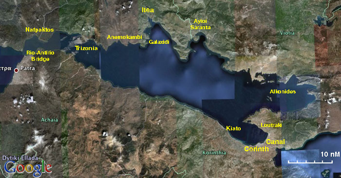

Korinthiakos Kolpos (Κορινθιακός Κόλπος) or Gulf of Corinth is dominated by the large commercial harbour of Corinth (Κόρινθος) at its E end and Patras just outside its W end. It is entered from W through the Gulf of Patras and under the Rion-Antirio bridge, the world’s longest cable-stayed bridge. From the E entry is through the Saronic Gulf and then via the Corinth Canal. The gulf is not heavily frequented by cruising yachts, but rather used as a passage route for yachts coming or going from the Ionian Sea to the Aegean. Nevertheless, it is an attractive and sheltered cruising area and there are several picturesque ports and anchorages, especially along its northern shores.
Charts
- BA
- 1600 Korinthiakós Kólpos
- Imray-Tetra
- G13 Gulfs of Patras and Corinth
- NIMA
- 54289 Korinthiakos Kolpos
- Greek
- 232 Korinthiakos Kolpos
Radio Nets
- Coast Guard - VHF channel 12, tel. +30 27410 28 888
- Olympia Radio - VHF channels 02, 64, & 85
Also see World Cruiser's Nets.
Weather
The prevailing wind in Korinthiakos Kolpos in the summer is from the west and it rarely exceeds force 6. Like the meltemi it reaches its peak in the middle of the day and subsides in the evening. In the autumn and spring the wind can be either from the east or from the west.
Danger: From the late autumn to the early spring the weather can be very volatile with violent thunderstorms. I have experienced very severe weather, force 9, while approaching Corinth. --Istioploos
Sailing from W to E you enter the gulf from the Gulf of Patras via the Rio-Antirio Strait.
Note: Yachts transiting the bridge W to E normally pass between the first pair of pylons on the S side; yachts transiting E to W normally use the first pair on the N side. It is essential to call up Rio Traffic on VHF channel 14 when five miles off the bridge and again when one mile off to receive clearance. Minimum clearance under the bridge is 25 metres. Yachts with exceptionally high rigs may need to request permission to use the channel between the two central pylons, which is normally resticted to commercial vessels. Yachts sailing from E to W enter via the Corinth Canal (see Wiki entry).
Ports, Anchorages, and Islands
Ports

Nafpaktos
Nafpaktos or Naupaktos or Lepanto is a jewel of a tiny mediaeval harbor well protected from from the the prevailing winds although SW and SE winds can cause some uncomfortable swell. The waterfront of the town is delightful. Unfortunately there are two problems that make this idyllic harbor less so: It is small and it is hard to find room (arrive early), and it is very noisy. The noise comes from the heavy truck traffic and from the music at night blaring out from a night club at the E entrance, just a few meters away from your yacht.
Anchor in about 3.0 metres depths and back up to the SE mole.
Warning: Be prepared to be squeezed by boats arriving after you.
Warning: As of Feb 2016, the south side of the port (left as you enter) was too shallow for our 1,65 meter draft boat. We touched the bottom, so we went away.


Galaxidhi
See separate Wiki entry for Galaxidhi.

Itea
Itea (Ιτέα) is a small commercial and fishing harbour, used mostly for agricultural products. A mile W of the town is a plant for the extraction of haematite, which sends a fine red dust over it and the harbour whenever the winds are in the west. The harbour has a large uncompleted marina with a long breakwater and three concrete piers. Local boats have moved in along the piers, but a visiting yacht can lie alongside the breakwater quay in depths of around 4.0 metres. Shelter here is excellent but the surroundings are rather soulless and there are no facilities in the ‘marina’. The harbour is, however, a useful alternative to Galaxidhi for leaving the boat for a visit to Delphi.
Itea is also a port of entry, however, since very few yachts call here, it may be better to clear into/out of Greece in more mainstream port where the bureaucratic procedures are more streamlined.
Kiato

Corinth
Corinth or Kórinthos is a large city on the SE of the Gulf of Corinth. While it has a large commercial harbour, its optimistically named Corinth Yacht Harbour has little to offer a cruising yacht and space is almost non-existent inside. If you are prepared to put up with mooring alongside just east of the commercial harbour, Corinth is a good place to leave the yacht while visiting the many interesting archeological sites within a few hours drive. There are berths alongside the wall for about 4 boats. The most westerly has depths of 4 metres, 20 metres along 2.6 metres, then shallower as you go east.
If you must try for a place in the yacht harbour, note that the only secure berths are alongside the end of two T pontoons to starboard once inside the harbour. The further one seems to be permanently occupied by a local boat and, if the nearer one is taken, you either have to raft up on it or go to the commercial harbour. If you are tempted to try going alongside the jetty that encloses the tiny fishing boat harbour, note that the depths here are less than 2.0 metres and that there are some fender-bursting projections along the wall - not a nice place to leave a yacht.
While the area around the commercial harbour is run down, the plazas immediately South of the Marina are surprisingly vibrant at night attracting many hundreds of happy people.
We spent only ten minutes investigating Corinth Yacht Harbour before deciding to head on to Kiato. Frankly, it's a dump. --Athene of Lymington 11:58, 14 September 2011 (BST)
Marinas & Yacht Clubs
None.
Anchorages

Anemokambi
Anemokámbi or Andromaki or Ayios Andreas is relative isolated, just some houses on the S side, almost landlocked cove on the mainland, a few miles W of Galaxidhi. Unfortunately there is a fish farm nearby (N entrance).
Anchor in 3-10 m. The bottom is mud and weed, good holding.Ayioi Saranda

Loutraki
Offshore Islands
Trizonia
See separate Wiki entry for Trizonia.

Alkonides
Alkonides is a very nice island on the SE of the Gulf of Corinth. It has lots of birds. Approach form the North.
Danger: There are large, just below the surface, boulders. Have a lookout at the bow while approaching.Yacht Repairs and Services
Marine Stores
None.
Repairs/Yards
None.
Fuel, Water, & Electricity
- Fuel
- In Nafpaktos the local gas station on the W side of the harbor runs a long hose to the quay
- In Galaxidhi a mini-tanker can deliver fuel to the quay
- In Corinth a mini tanker can be called
- Water
- In Nafpaktos there is an outlet is on the S mole
- On the quay of Galaxidhi
- There is an outlet on the quay Corinth but it may be locked. Ask for the attendant
- In the hamlet of Trizonia
- Electricity
- On the quay in Galaxidhi
Things to do ashore
Tourism
 Boat Painting Galxidi Nautical Museum Click for larger view |
 Delphi Click for larger view' |
 The Charioteer of Delphi |
 The Temple of Athena, Delphi |
 The theatre, Delphi |
 Frieze, Delphi museum |
 The Gates of Mycenae |
In Nafpaktos
Walk around the ramparts of the harbour. Also, if you have time walk up to the castle with its distinctive bell-tower.
In Galaxidhi
Other than wandering in its lovely streets you should visit the Nautical Museum which houses a good collection of 19th century model ships (built in Galaxidhi), paintings, figureheads, and nautical instruments. Also worth visiting is the Archaeological Collection which is housed within the Nautical Museum. Unmissable is the wonderful carved iconostasis of the church of Agios Nikolaos (see separate Wiki entry for Galaxidhi)
Delphi
From Galaxidhi you can take a taxi or a local bus to Delphi, about 10 km. Delphi is one of the most significant archaeological sites in Greece. While in Delphi visit the Museum which houses many masterpieces along with the breathtaking Charioteer.
From Corinth
From Corinth one can visit Ancient Corinth (also the Museum there) and Acrocorinthos, as well as Isthmia and the Isthmia Museum (several of the exhibits there from Kechries have been found by my wife Dr. Alice S. Riginos and even a few underwater finds by me --Istioploos 16:48, 9 May 2008 (MDT)).
Further away from Corinth there are the most important Bronze Age sites of Mycenae (the citadel, the tombs, the museum) and Tiryns.
Grocery & Supply Stores
- There are several stores in Nafpaktos
- Good provisions shopping in Galaxidhi
- In the town of Corinth there is excellent provisions shopping
- Limited provisions in the store in Trizonia
Eateries
- The taverna under the large plane tree in Nafpaktos has a wonderful assortment of mezedes (appetizers) to accompany your ouzo
- There are several restaurants on the waterfront of Corinth
- Good fish restaurant in Ayioi Saranda
- In Trizonia there are several good tavernas along the waerfront.
Internet/WiFi
Available?
Laundry
- On Trizonia, the Drymna hotel will do laundry. Washing only. No drying. 10 Euros a load. (They also have showers for 4 Euros)
Motorbike & Car Rentals
Transportation
From most ports there is a bus to Athens. From Patras and Corinth there is also a train.
Routes/Passages To/From
Cruiser's Friends
Contact details of "Cruiser's Friends" that can be contacted for local information or assistance.
Forum Discussions
List links to discussion threads on partnering forums. (see link for requirements)
External Links
- Korinthiakos Kolpos at the Wikipedia
- Nafpaktos at the Wikipedia
- Delphi at the Wikipedia
References & Publications
See Greece.
Comments
We welcome users' contributions to the Wiki. Please click on Comments to view other users' comments, add your own personal experiences or recommend any changes to this page following your visit. Personal experiences?
Verified by
Date of member's last visit to Korinthiakos Kolpos and this page's details validated:
- 1986 (Ayioi Saranda) --Istioploos

 Travels with S/Y Thetis
- June 1995 (Nafpaktos, Anemokambi, Loutraki, Alkonides) --Istioploos
- September 2004 (Corinth) --Istioploos
- July 2010 (Nafpaktos) --CORFUBOAT

- August 2010 (Corinth) --Paologull
- September 2011 (Itea, Kiato, Corinth) --Athene of Lymington 18:51, 15 September 2011 (BST)
- June 2013 (Itea)--Vigdis yachtvigdis blog
- June 2015 (Corinth) --Monterey

- Feb 2016 (Nafpaktos) --Stefvero
| This is a usable page of the cruising guide. However, please contribute if you can to help it grow further. Click on Comments to add your personal notes on this page or to discuss its contents. Alternatively, if you feel confident to edit the page, click on the edit tab at the top and enter your changes directly. |
| |
|---|
|
Names: Istioploos, Paologull, Athene of Lymington, CORFUBOAT |